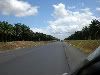
maps.google.com shows about the first one third of the highway. Highway 8 is 105 km from beginning to end. There is one rest stop and a couple of exits for locals living near the highway. Basically you get on in Santo Domingo Este and get off in Nagua. It is a straight run.
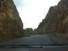
In my opinion DR-8 (also known as Carretera Juan Pablo II, Carretera del Nordeste, Carretera Santo Domingo-Samana) is the best highway I have driven on in the DR.
i have the pdf map that was being passed around last year that shows it. pm me your email and i will try to send it, ben ps... here is the link to download it http://rapidshare.com/files/229977154/dominicana.pdf
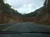
In my opinion DR-8 (also known as Carretera Juan Pablo II, Carretera del Nordeste, Carretera Santo Domingo-Samana) is the best highway I have driven on in the DR.
i have the pdf map that was being passed around last year that shows it. pm me your email and i will try to send it, ben ps... here is the link to download it RapidShare: 1-CLICK Web hosting - Easy Filehosting

")