
- Thread starter jinty05
- Start date
You are using an out of date browser. It may not display this or other websites correctly.
You should upgrade or use an alternative browser.
You should upgrade or use an alternative browser.
tremor
Tremor
Definitely felt in Montellano near the ayuntamiento!!
felt it pretty strong in POP.
Definitely felt in Montellano near the ayuntamiento!!
Shook the whole house while I was making spaghetti sauce.
Seventeen miles outside of Santiago...........
Seventeen miles outside of Santiago...........
According to this site their seems to be a long history of seismic activity on the island. 295 quakes in the last year. Compare this with 2 for Cuba and zero for Jamaica that makes me think the island is sitting on or near an active fault line.
http://earthquaketrack.com/p/dominican-republic/recent
I assume this means the island will someday experience a quake like what was seen in Haiti some years back. Let's all pray it's hundreds of years away...
As a side note I was in my hotel room in Santiago about a year ago and felt several strong shakes but did not pay much attention to them not thinking/knowing about the potential for a major quake. Moving forward any signs of tremors and I will be calmly looking for relative safety...
Two major fault lines. Being the same island as Haiti it had that experience. Time will tell when the eastern part of the island has that experience. I was boarding the air plane in California to move to the DR full time at the same time the 2003 earthquake hit Puerto Plata.
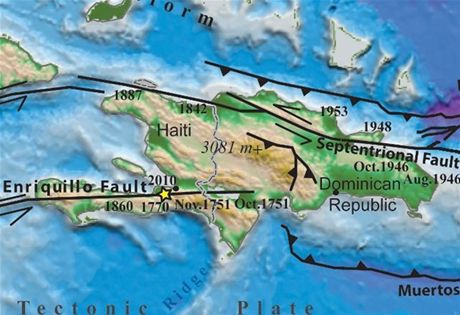
The image above shows the two major fault lines in Hispaniola. The one in the north follows the Sierra Septentrional mountain range which is visible from Luper?n harbor. The one in the south is named for the below-sea-level salt water lake Enriquillo in which the fault ends.
The bays at Luper?n are the end of a spur of the Septentrional fault. The Haiti earthquake of 2010 is shown, but for some reason, the Puerto Plata earthquake of 2003 is not shown.
Also shown are the locations of the North American (North Atlantic) and Caribbean tectonic plates. The N.A. plate is sliding under the Caribbean plate. These plates are also refrerred to, respectively, as the Hispaniola Fault and the Muertos Fault.
Excellent post windeguy.
The island of Hispaniola sits on the eastern edge of the Caribbean tectonic plate. It borders the North American plate as well as the South American Plat AND to the west the Cocos Plate.
There is even a spur of the Nazca Plate that touches the underside of the Caribbean Plate.
The major fault lines: Enriquillo, Muerte and Septentrional are assisted by many smaller faults...and a big one is a distinct possibility.
When, nobody knows..
Stay tuned.
HB
I believe these tremors are warnings of something big yet to come. The earth has been
restless with more frequent tremors than before.
I've been in contact with family members and told them to prepare just in case. Although
there's really not much you can do ahead of time like a hurricane (you know when it's coming) and
people do panic which is understandable but I've told them not to forget to turn off the gas which
is very important.