2014 Hurricane Season

Status
Not open for further replies.

bronzeallspice

Live everyday like it's your last
Mar 26, 2012
11,009
2
38
Relentless drought means water rationing

Santo Domingo.- If the current drought parching the country continues, the water supply already in crisis will get even more severe for Greater Santo Domingo’s population.

The dire warning came Wed. from Santo Domingo Water Utility (Caasd) director Alejandro Montas, who called worrisome the situation of the major dams that supply water, since they operate at just 3 and 11 per cent of their capacity.

He said if the situation continues, the Utility will have to readjust the distribution of piped water, reducing the number of days and hours for service in all sectors of the National District and Santo Domingo province.

Montas said his agency spends RD$234,000 daily to rent tank trucks to distribute to people and sectors that request it, free of charge.

He said all water deliveries will be monitored "tank by tank, bucket by bucket, and gallon by gallon in the most affected areas," as well as the filling of the trucks to public hospitals, prisons, schools, law enforcement agencies and households that can store water.


Dams and Aqueducts Agency (Indrhi) director Olgo Fern?ndez said despite reduced levels, conditions

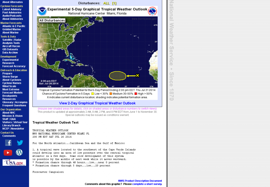
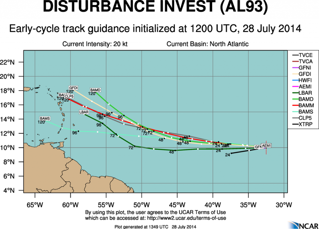
in some dams could improve in the coming days with the RAINS FORECASTED OVER SEVERAL REGIONS.

fingers crossed.:)

http://www.dominicantoday.com/dr/local/2014/7/24/52226/Relentless-drought-means-water-rationing
 

donP

Newbie
Dec 14, 2008
6,942
178
0
Let's see......

FireShotScreenCapture057-Atlantic5-DayGraphicalTropicalWeatherOutlook-www_nhc_noaa_gov_gtwo_php_basinatlcampfdays5_zps2fbb9b86.png


donP
 

bronzeallspice

Live everyday like it's your last
Mar 26, 2012
11,009
2
38
MIAMI (AP) — The U.S. National Hurricane Center says a tropical depression in the Atlantic has weakened to a tropical wave as it approaches the Lesser Antilles.

Its maximum sustained winds Wednesday are near 35 mph (55 kph).

It is centered about 365 miles (590 kilometers) east of the Lesser Antilles and is moving west-northwest near 25 mph (41 kph).

Forecasts say the storm is likely to move quickly westward through the Lesser Antilles on Wednesday evening. It also is forecast to continue weakening.

There goes that much needed storm..:ermm: What a bummer.:tired:


Tropical depression weakens to tropical wave
 

donP

Newbie
Dec 14, 2008
6,942
178
0
Different Systems

MIAMI (AP) ? The U.S. National Hurricane Center says a tropical depression in the Atlantic has weakened to a tropical wave as it approaches the Lesser Antilles.

I think you and I are looking at different systems.... ;)

don
 

donP

Newbie
Dec 14, 2008
6,942
178
0
Now 40%

Update for the Tropical Wave

"By the middle of this week, however, environmental conditions are expected to become conducive for gradual development over the central tropical Atlantic as the system moves westward at 10 to 15 mph."

The chance for a formation within the next 5 days is about 40 percent.

donP
 

william webster

Platinum
Jan 16, 2009
30,247
4,330
113
we had showers the last couple of days in SD but are doing the rain dance. They say that we only have enough water for 30 days in the resevoirs.

Shower with friends.

is that an invitation for me and sweet smelling CCCCologne ??

CCCologne--- breakout that new ropa interior !!!
 

donP

Newbie
Dec 14, 2008
6,942
178
0
Now 70%

TROPICAL WEATHER OUTLOOK
NWS NATIONAL HURRICANE CENTER MIAMI FL
800 AM EDT MON JUL 28 2014
(...)
Formation chance through 5 days...high...70 percent.

mostrecent_track_early_zps2f91bf7c.png


donP
 
Last edited:

Olly

Bronze
Mar 12, 2007
1,914
104
63
Further Track information at : Graphical Tropical Weather Outlook

Additional from NHC :
A tropical wave located several hundred miles southwest of the Cape
Verde Islands is producing disorganized cloudiness and
thunderstorms. Environmental conditions are expected to be
conducive for gradual development of this disturbance over the next
several days while it moves generally westward at 10 to 15 mph.
* Formation chance through 48 hours...medium...30 percent.
* Formation chance through 5 days...high...70 percent.


Olly and the Team
 

Olly

Bronze
Mar 12, 2007
1,914
104
63
update from :

NWS NATIONAL HURRICANE CENTER MIAMI FL
800 PM EDT MON JUL 28 2014

For the North Atlantic...Caribbean Sea and the Gulf of Mexico:

Shower and thunderstorm activity associated with an area of
disturbed weather located about 850 miles west-southwest of the Cape
Verde Islands has become a little better organized during the past
few hours. Environmental conditions are expected to be conducive for
gradual development, and a tropical depression could form during the
next several days while the system moves generally westward or
west-northwestward at 10 to 15 mph.
* Formation chance through 48 hours...medium...50 percent.
* Formation chance through 5 days...high...70 percent.

Keeep watching this one !

Olly and the Team
 

donP

Newbie
Dec 14, 2008
6,942
178
0
Almost certain to become a storm

Update on Invest 93L:

The probability of the disturbance to become a storm ("Bertha") remains high at 80 %.
The system may become a TD later today.
It may curve to the north before it reaches the Lesser Antilles, but depending on the size we could get the much needed rain from it.

Atlantic 5-Day Graphical Tropical Weather Outlook

donP
 

donP

Newbie
Dec 14, 2008
6,942
178
0
Spaghetti Lines

Only one of the projected paths comes across DR:
View attachment 1574

We need to check the computer models more often now:
http://www.wunderground.com/hurricane/atlantic/2014/Invest-93L?map=ensmodel

Of course, the spread of those spaghetti forecast lines is rather wide, as the system is still far off.
Much will depend on the wind shear situation and the amount of dry air in the north.
I guess, 3 days from now, we shall have a fairly accurate forecast map.

donP
 
Last edited:

bronzeallspice

Live everyday like it's your last
Mar 26, 2012
11,009
2
38
The system 93L is still very far away but " (93L), has the potential to develop into a tropical depression by Wednesday, but is struggling with high wind shear today. Visible satellite loops on Tuesday morning showed improved organization to 93L with more spin and some low-level spiral bands beginning to form. A 7:30 am EDT July 29 pass from the ASCAT satellite showed plenty of west winds on the south side of 93L's center of circulation, so the storm is close to having a well-defined closed surface circulation. However, infrared satellite images showed that the system's heavy thunderstorm activity had diminished somewhat since Monday, and the storm is now fighting high wind shear of about 20 knots. Water vapor satellite loops and the Saharan Air Layer analysis showed that 93L had more dry air to contend with than on Monday, with some tendrils of the dry Saharan Air Layer to the north encroaching into the circulation. Ocean temperatures have cooled since Monday, and are now marginal for development, about 27?C.


"All of the models predict that the disturbance will continue west or west-northwest at 10 - 15 mph for the next four days."


But the predictions of what turn it will take after that varies as the disturbance is still far away:

"The UKMET and the European models offer the fastest solution, predicting that the disturbance will arrive in the northeast Lesser Antilles Islands on Friday evening, move over Puerto Rico on Saturday evening, and approach the Southeast Bahamas and Turks and Caicos Islands on Sunday evening.


"The GFS and European models have come into better agreement on the long-range fate of 93L. The great majority of the 20 members of the 00Z and 06Z Tuesday runs of the European and GFS ensemble models (which run at low resolution 20 times with slightly different initial conditions to show a range of possible outcomes) showed 93L taking more of a northwesterly track early next week, passing to the north of Hispaniola and not making an extended track through the Caribbean Sea. This raises the odds that the strong trough of low pressure over the Eastern U.S. will be able to recurve 93L out to sea without the storm hitting the mainland U.S. coast.


The Press-Enterprise - Weather


Disturbance (Invest 93L) - 7/29/2014 12Z - NHC Models on a Google Map
 

bronzeallspice

Live everyday like it's your last
Mar 26, 2012
11,009
2
38
please beg let it rain in POP!

You may get your wish. It is predicted that it will pass to the north of Hispaniola
but not make it to the Caribbean Sea. Looks like SD will miss it, if the predictions are correct.:ermm:
 
Last edited:
Status
Not open for further replies.