2018 Hurricane Season

MikeFisher

The Fisherman/Weather Mod
Feb 28, 2006
13,771
2,206
113
Punta Cana/DR
www.mikefisher.fun
Soooo,
It is this time of the year again.
Still not fully ready with all maps and direct features, as i switched for this season from PCand Laptop to pure Tablet work. It makes me more independ from power outs and the pocketjuices keep me connected for a very long time without power, as long as the batteries on the Claro Tower hold up to provide a internet connection.
Still trying to get used to the different keybord, but on time for our local stormy primetime i will bring the best fitting equipment from my Europe Vacation, leaving here June 19thfor funtastic 7 weeks with my Baby Daughter to spend the summer with the german grannies, those poor Folks still dont have an idea what kinda stormy forces will hit them all summer long, lol. We will be back on august 7th here on the Isle and in the mean time keep an eye on any stormy deve!opments from abroad.
Hey, todays those Germans have internet, too. And more or less reliable electricity to use a 'puter.

The head start of this2018 Season goes to southern Florida.
We have actualy a nice looking low pressure system developing over the Eastern Gulf of Mexico, which
should bring at least some good amounts of Water over the south of the Sunshine State.
No maps or such from me at this time, as nothing actual is any near our Paradise Isle.
Our local area is still under the influence of a nice strong High, so we should have many more sunny days ahead of us for this week.

The waters over the different parts of the highway are for this time of the year on their normal/average levels, so as a long range outlook we have nothing special to fear.
We have, as usual, to take it as the season proceeds and develops.
Week by week of living in Paradise.
I will be back here as needed, so hopefully not any soon.
I just started this Topic so we have our place where we can chat, report and fun all around those windy things.
Have a great sunny sunday and a windfree 2018 Season y'all

Mike
 

MikeFisher

The Fisherman/Weather Mod
Feb 28, 2006
13,771
2,206
113
Punta Cana/DR
www.mikefisher.fun
The Outlook (a Fisher 'guess') for the season to come.
Starting tomorrow for the East and shortly afterwards the rest of the Island the rainy phase should be over.
Til end of the month we will very likely stick to winds a bit above our used to breezes, but aside of the ocassional short tropical bursts we should stay for most part on the dry side with the heat to start going upwards steadily.
For the months June, July, August we can await to get extra hot and dryer than our anyways dry summer time, the danger for a couple months of a drought period is looking very high for 2018.
This goes for the Eastern Caribbean as a whole wide Area.
The opposite is the case for the western caribbean, where it will stay very wet and rough at least for the rest of the month May, with heavy water loads to continue over the NWern caribbean and southern Florida.
Looks like a hot dry summer for us easterners over here,
Stay Hydrated, keep the beercoolers stocked and iced
And also take care that your cattle stays hydrated,
Those animals most likely have a bit of a hard time ahead of them.
 

Vinyasa

Bronze
Dec 22, 2010
1,419
6
38
www.kieranbarry.com
this past week has been a bit windy, especially in the afternoons.


Speaking as a kitesurfer, I would say this has been one of the longest periods of really strong winds I have ever seen here. There has basically been 20+ knots every day now for the last 5 weeks...
 

MikeFisher

The Fisherman/Weather Mod
Feb 28, 2006
13,771
2,206
113
Punta Cana/DR
www.mikefisher.fun
We had been/still are super windy here on the east shores since thursday a system brought awaited and forecasted winds and waterloads over the USVI and PR and continued to our side of the channel. The prior weeks been so far normal conditions with normal ups and downs of wind and waves, appropriately for the time of the year so far.
It wouldn't be ME, if i would just repeat what weather sides think to know.
Too me wemwill stay anshort longernwhilemwindier as usual but rainfall will stop, at least here on the East. Not a drop of rain at my place so far today already, while the breeze is still gusting up heavy.
til the beginning of our Peak Time for Hurricane Season mid august we will run very dry and be happy about every "lil stormy cloud" to dump down some water once reaching mid august.
As for the hurricane season so far as a outlook,
I dont agree with the sensationalizing press about a hyper active season to come.
I see ahead of us not very hot sea surfaces out there on out far eastern highway, so early and numerous running big boys and gals are at this point not a theme, the conditions simply do not call for such asumptions at this moment.
What the press, a Trumpeter influenced and by their governemnt steered medium, is "promising", is a 60% chance of a Hurricane hit for the Eastshores of the USA.
I have no idea where such calculation could come from and anyways, a high chance of a us east hit has nothing to do with a hyperactive or below average moving season/number of named stroms.
1 single storm during a dead slow movimg season, on the right path, would become a record devastating occurrance for that area, while we also saw so often way above average active seasons with no significant hits near our soil, those american chances calling simply mean nothing for our to be awaited conditions.
If we consider the coming season to become very active or not, we will not be able to decide/comment on before end June, as by then the patterns of warming waters etc will show a real pattern to use for c conclusions/calculations.
By now, the biggest fear is a too dry early summer, as such would have significant damaging influence on agriculture for our own Isle.
 

MikeFisher

The Fisherman/Weather Mod
Feb 28, 2006
13,771
2,206
113
Punta Cana/DR
www.mikefisher.fun
Speaking as a kitesurfer, I would say this has been one of the longest periods of really strong winds I have ever seen here. There has basically been 20+ knots every day now for the last 5 weeks...

You are on the North Shores, right?
Right now we also habe nice conditions for the Kites here on the East, but not for too lenghty time periods.
This month they should stay nice at least til end May, tho.
 

Vinyasa

Bronze
Dec 22, 2010
1,419
6
38
www.kieranbarry.com
You are on the North Shores, right?
Right now we also habe nice conditions for the Kites here on the East, but not for too lenghty time periods.
This month they should stay nice at least til end May, tho.


Yes, Cabarete. Wind has been starting early and just blasting all through the afternoon and well into the night...last night until 1am! This is not usual but im not complaining :)
 

MikeFisher

The Fisherman/Weather Mod
Feb 28, 2006
13,771
2,206
113
Punta Cana/DR
www.mikefisher.fun
Yes, Cabarete. Wind has been starting early and just blasting all through the afternoon and well into the night...last night until 1am! This is not usual but im not complaining :)

I hear you.
My Kite and Surfing buddies over here do not complaint neither, as we have the same comditilns over here, too, this weekend.
Me, the fisherman, is of course not happy, as i could today run only one out of 8 boats. And that one was a lucky shot to have a real sea leg hard core angler who chartered tje smallest boat for 3 full days, not willing to reshedule or cancel just due 20knots blowing winds and 10ft very heavy running Sea.
Today was his 1st day and he stood it all, took stand up fighting without the use of a fighting chair 16 nice Mahi and missed on a white Marlin.
He will be back on Tuesday and wednesday.
lazy family day for me, tho, with the MIL arrived for a week or so.
so i get new variety of cooking in the house, nothing bad at all, lol
 

MikeFisher

The Fisherman/Weather Mod
Feb 28, 2006
13,771
2,206
113
Punta Cana/DR
www.mikefisher.fun
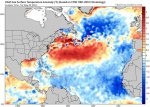
Today lets have a look on the very important and for a long range outlook significant Sea Surface Temperatures(SST).
They nicely underline my antipation of the media hyped promises of a high active season.

FB_IMG_1527168830495.jpg
FB_IMG_1527168852249.jpg

As the graphs show, the SST out on the Tropical Atlantic, our Highway,
Are well below the average awaited temps for this time of the year.
The 2018 Hot Zones for Tropical Storm Formations and awaited conditions to support quick developments of upcoming Storms, are located im the northern Gulf of Mexico and along the north shores of the Eastern US Coastline.
This is a highly unusual constellation, but it indicates the less likelyhood of forming the BigBoys and Gals out East, the so named Cape Verde Cyclones. It also indicates high danger for the North of the US East to get Tropical Storm Formations forming up there, which i guess is the reason for the high probabilities of a US Mainland storm hit given by so many US weather entities on their 2018/Season outlook.
Such Storms forming close to the coast have on most ocassions not the time to become so named super cyclones, but to bother dangerously no super storm is needed, Sandy for example was "just" a Tropical Storm.
Where close to the coast forming Tropical Storms are extra dangerous, as they raise the power bar quickly in record time due the specific conditions patterns there, is the Gulf of Mexico, where upcoming systems well often become a TS in no time and a couple days later show highest powers.
A good example is the actual first noticed system of the Season, Invest 90L, in the NE ern Gulf, and that today on May 24th, well earlier tham anything would be awaited anywhere.
I stick to my "safer than average" outlook for the Hurricane Highway, which is the place where 95% of the danger for our Island comes from, but i agree to the way above average danger outlook for the East and Gulf Coast of the US Mainland.
These charts are the first ones i add on this tablet, which i am far from beeing used to use, yet.
I hope ll shows up and typos are within the acceptable margins. Lol
 

MikeFisher

The Fisherman/Weather Mod
Feb 28, 2006
13,771
2,206
113
Punta Cana/DR
www.mikefisher.fun
May 25th and we have the first storm of the season up and in a awaited for area.
Subtropical Storm Alberto formed over the NWern Tip of the Caribbean Sea and will wander the comfy waters of the Gulf Northwards.
hotpoint for the season's first Landfall will be around the Alabama/Mississippi border.
Alberto will not become something big by Wind Force,
but it already carry's a heavy waterloo and will continue to collect more water on the way.
the SE USA will get a heavy dump-down of water from this one.

nothing out there near our Isle.
 

Drake

Bronze
Jan 1, 2002
667
23
18
Update
Disturbance 2: 30% Chance of Cyclone Formation in 48 Hours
As of 2:00 pm EDT Wed Jul 4 2018 ...
Shower activity has changed little in organization near a small
area of low pressure and tropical wave located several hundred miles
west-southwest of the Cabo Verde Islands. In addition, recent
satellite-derived wind data and visible satellite images suggest
that the system may not have a closed surface wind circulation.
Some development of this system is possible during the next day or
two while it moves westward at 10 to 15 mph over the tropical
Atlantic Ocean. Upper-level winds are expected to become less
conducive for development by this weekend when the system approaches
the Lesser Antilles.
* Formation chance through 48 hours...low...30 percent.
* Formation chance through 5 days...low...30 percent.
 

Cdn_Gringo

Gold
Apr 29, 2014
8,672
1,133
113
NOAA reports it will intensify for the next three days than encounter poor conditions and downgrade itself.