I think that the Wizard of Oz is available. Try that.No guessing allowed Mike. Only detailed study of the steering patterns and then your best take on those results.
- Thread starter Olly
- Start date
You are using an out of date browser. It may not display this or other websites correctly.
You should upgrade or use an alternative browser.
You should upgrade or use an alternative browser.
2020 Hurricane Season
- Status
- Not open for further replies.
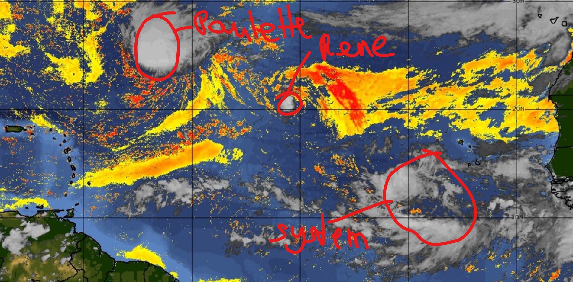
TS Paulette is powerful and growing.
Rene in the wake of Paulette is going down.
none is any problem for DR.
the extreme wide area SW of Cabo Verde is what we have to watch after the weekend closely,
as this wide area of moisture and thunderstorms is running under the influence/with a strong Surface Low Pressure Area,
moving on a quick pace of maybe 15mphr Westward.
windpowers there are strong, so TD 20 could be shown on the Maps at any moment, it could also take an other couple days before it show's.
it is dificult and time consuming to get such very wide area organized as one system under control of one Low Center.
so, most likely such will happen during the next several days by cutting down on size, grouping some Thunderstorm areas around the Low, leaving other areas behind.
as long as not formed, Tracking is impossible to do.
of course it is shown to move West, all those Tropical Waves move in general from E-W.
the exact direction will depend on at which exact positioning the Center/Low will be once a strom forms/area get's organized.
remember, such "centers" seem to "jump" up and down on the map during such process quiet often, before it's final structure is done and ready.
the more S it forms, the more likely it will walk to the Caribbean.
the more North, the more likely to just scratch over the northernmost Islands or even miss all by their NE.
out of all the stuff in the forecasts, this is the one to watch out for during this weekend and specially once a storm structure formed and show's a pattern.
but first of all, we will enjoy our Weekend,
nothing of danger near our Island for this weekend
Last edited:
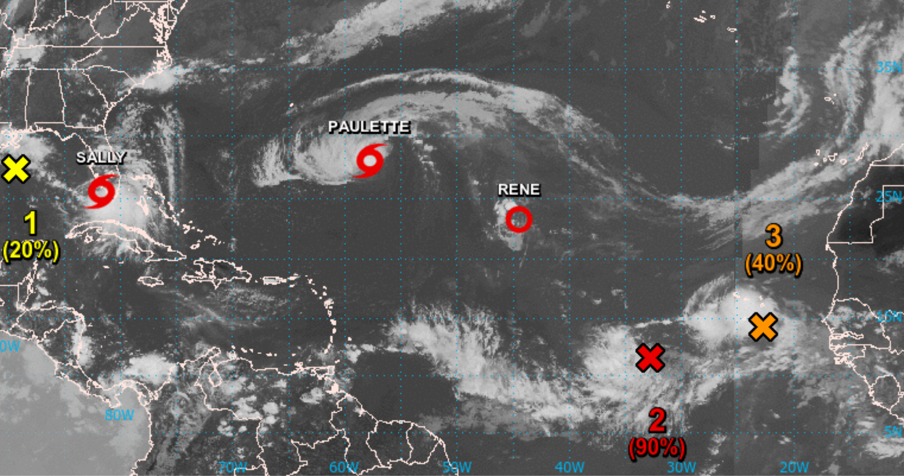
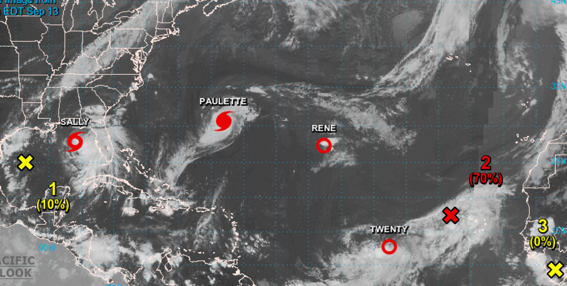
None of the actually 6 TS and TD and Systems is so far of any concern for us.
the closest to a "threat" for DR would be the Disturbance Red Cross 2.
this should be declared a TD any moment today.
for this system the Low Center is still located East of the controlled area of moisture and thunderstorms,
but the Trend is that it will get it's structure together and form a Storm.
I await this to happen with the Center then located later today somewhere 13th-15thN.
that's on this far distance E of the Caribbean a suitable position for us, as it means the steering currents will bring it WWNW-WNWwards,
to miss the Islands on their NE and most likely turn out on Open Atlantic even well before coming close to the Caribbean.
the area of distirbed weather at the Cabo Verde Islands, shown Orange Cross 3, will never come on a way towards the Caribbean,
so it does not matter if it will develop or not.
TS Paulette is out there the most powerful one and should reach Hurricane Status later today.
it run's as awaited since already a week ago, not anywhere near to DR.
Rene, in the wake of Paulette, got fleddered and as a storm destroyed.
it could stay out there as a small area of a TD for an other week or so, but at this point conditions do not indicate that it could come back as a TS.
it should disappear later next week somewhere N/NE of the NEern Caribbean Islands. steering currents on it's path are very week, it could happen that it stays as a TD for days almost stationary, sometimes such weak storms then get even pushed around in circles in such area.
TS Sally is over southern Florida and not of concern for us, so it the Disturbance in the NWern Gulf.
6 Storms/brewing Storms, including at least one Hurricane later today, on the Map at a time,
BUT NOTHING in this for US, we will just continue a sunny calm caribbean paradise weekend
and can expect similar for the coming week.
cheers
all around us but we are home free !
Thanks Fisherman
Glad to hear that - my wife arrived today.....me = next week
Thanks Fisherman
Glad to hear that - my wife arrived today.....me = next week
Now, that looks good. Time to get worried about something else meanwhile... 
that's on this far distance E of the Caribbean a suitable position for us, as it means the steering currents will bring it WWNW-WNWwards,
to miss the Islands on their NE and most likely turn out on Open Atlantic even well before coming close to the Caribbean.
I think you might have too many W's in that first direction Mike. What direction are you trying to indicate? Closer to due West than West North West? More west is not a good direction for us.
I read it as closer to W.... just break the compass into more pieces....
try WWWNW.... a fraction more west - huh??
try WWWNW.... a fraction more west - huh??
WunderMap® | Interactive Weather Map and Radar | Weather Underground
Weather Underground’s WunderMap provides interactive weather and radar Maps for weather conditions for locations worldwide.
www.wunderground.com
Some pretty pictures for those that need them.
I have all the faith in Capt. Fisher and understand him 100%.
I've owned and have captained several vessels, and still do on rare occasions.
Lt Cdr. Ret. Also was member of other ship/marine organizations.
Old school gives important valuable basics that combine with tech. When at sea, I still have a sextant and chart and I plot.
lol.I think you might have too many W's in that first direction Mike. What direction are you trying to indicate? Closer to due West than West North West? More west is not a good direction for us.
View attachment 3352
yes, WWNW is the middle between WNW and West on your compass.
we have at this moment nothing to worry about and at this time not even the longest of longshot forecast guesses shows anyhing to threaten our Island.
sure, such can change quickly this time of the year, a disturbance could pop up over night close to the East of the Caribbean or SE of DR in the Eastern Caribbean Sea and form into a TS within short hours, to become a threat. such things happened before.
but at this moment nothing of such is in the make anywhere and none of the far away areas of disturbed weather is on any position, from where it would be awaited to wander into our direction.
the steering currents are weak but clear, tho all active areas E of the Caribbean are at this moment and for days to come Heading WNW and then turn up more Northward.
Hurricane Paulette could only become a threat for Bermuda as the only Landmass to reach.
Ex-Rene is a dying ex-storm.
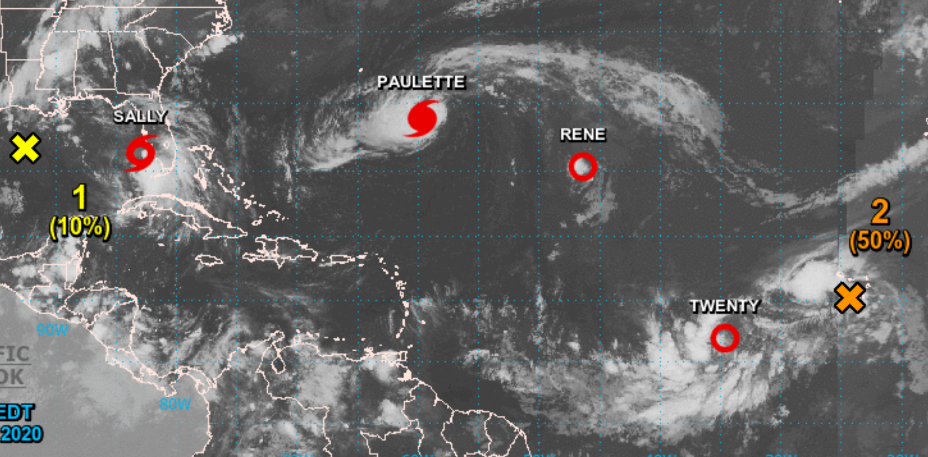
TD20 is still trying to unite a very wide area ofthunderstorms and moisture, hence the slow development.
it is around the Low Center a well organized system and should manage to get the W and SW of the Center located area closer to the Center and wrap them around it. I don't think this one needs more than 2 more days to get this done and build a Wall around the L-Center/means to be a Hurricane.
it should already be a TS by today/Sunday afternoon.
Important to us is the Steering Currents:
TD20, of what ever powers it will reach, will not come close to the Caribbean at any time,
it will be tracking up northwards to the open central Atlantic and never threaten any land.
the Orange Cross 2 is already too far North under given steering currents, so it will move up to northern directions from the beginning.
the Cabo Verde Islands are the only land to get influenced by it.
and this one is for our Canadian follower, to not get scared because i mentioned above the possibility that something not shown on any map could pop up over night in the caribbean sea and develop quickly:
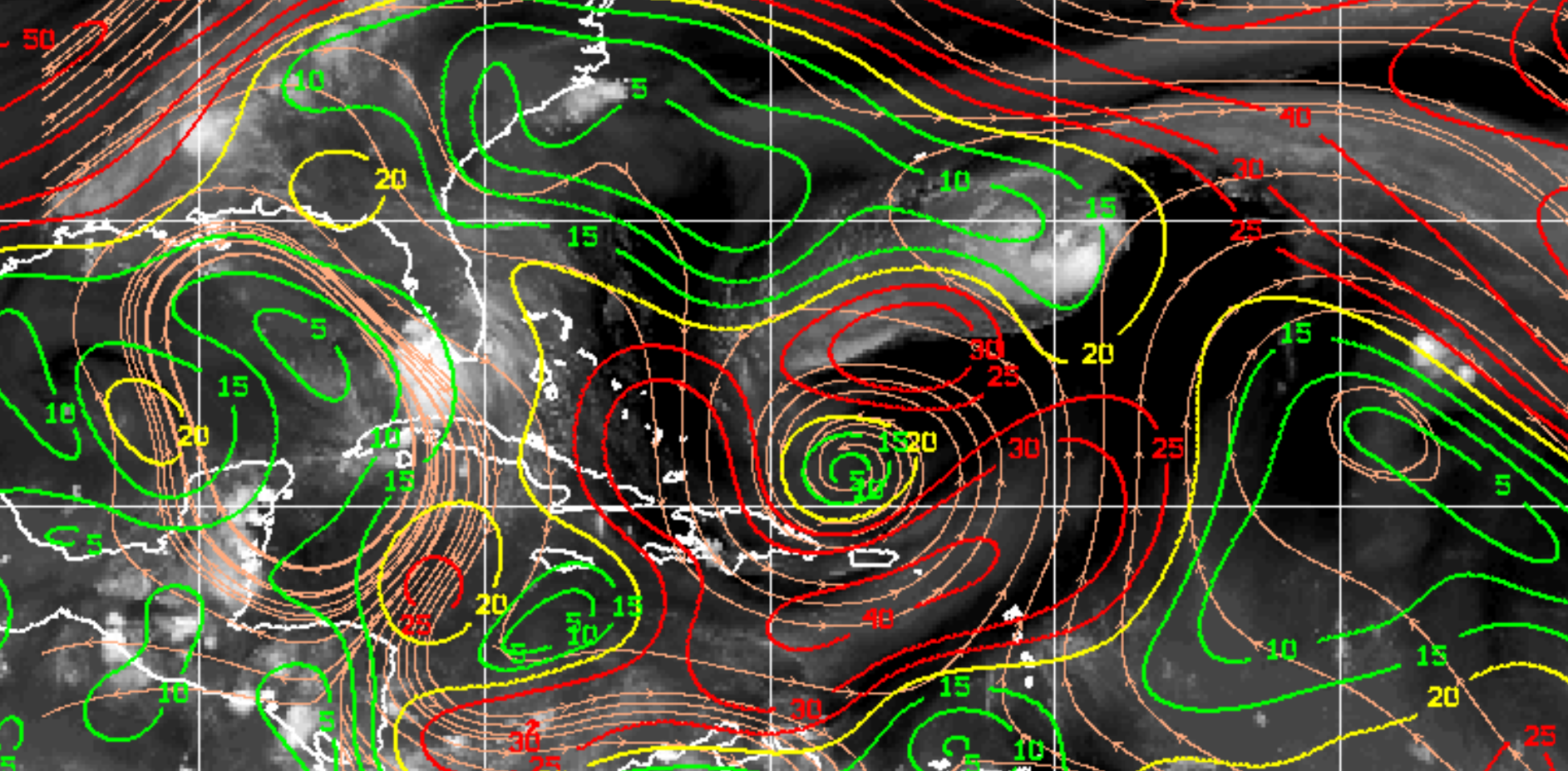
we have actually over the Eastern and Central Caribbean Sea a wide area of quiet harsh 30+ Knots Windshear,
so during this weekend no system popping up here(near DR) would have a chance to any quick development, not even into a small storm.
so simply, Don't Worry about anything this weekend, just enjoy.
our Tropical Highway between Africa and the Caribbean is ready, conditions for storm developmentare good,
but the steering xurrents will actually not bring anything into our direction.
so all is good for now.
sure, such can change quickly this time of the year, a disturbance could pop up over night close to the East of the Caribbean or SE of DR in the Eastern Caribbean Sea and form into a TS within short hours, to become a threat. such things happened before.
but at this moment nothing of such is in the make anywhere and none of the far away areas of disturbed weather is on any position, from where it would be awaited to wander into our direction.
the steering currents are weak but clear, tho all active areas E of the Caribbean are at this moment and for days to come Heading WNW and then turn up more Northward.
Hurricane Paulette could only become a threat for Bermuda as the only Landmass to reach.
Ex-Rene is a dying ex-storm.
TD20 is still trying to unite a very wide area ofthunderstorms and moisture, hence the slow development.
it is around the Low Center a well organized system and should manage to get the W and SW of the Center located area closer to the Center and wrap them around it. I don't think this one needs more than 2 more days to get this done and build a Wall around the L-Center/means to be a Hurricane.
it should already be a TS by today/Sunday afternoon.
Important to us is the Steering Currents:
TD20, of what ever powers it will reach, will not come close to the Caribbean at any time,
it will be tracking up northwards to the open central Atlantic and never threaten any land.
the Orange Cross 2 is already too far North under given steering currents, so it will move up to northern directions from the beginning.
the Cabo Verde Islands are the only land to get influenced by it.
and this one is for our Canadian follower, to not get scared because i mentioned above the possibility that something not shown on any map could pop up over night in the caribbean sea and develop quickly:
we have actually over the Eastern and Central Caribbean Sea a wide area of quiet harsh 30+ Knots Windshear,
so during this weekend no system popping up here(near DR) would have a chance to any quick development, not even into a small storm.
so simply, Don't Worry about anything this weekend, just enjoy.
our Tropical Highway between Africa and the Caribbean is ready, conditions for storm developmentare good,
but the steering xurrents will actually not bring anything into our direction.
so all is good for now.
Hey Mike. No need for a big long post, I have the NHC bulletins for that. I did want to ask if you see anything different than they do at the moment? Any idea how long those steering currents that are pushing everything northwest are going to last?
Wow,
seldomly the Map been that busy with 7 !!! Storms and Systems at a time.
TS Sally, which I do not following in details, looks like a Hurricane Hit into the Mississippi Delta, a very vulnerable area for such event.
Hurricane Paulette continues rising powers and will be a Mayor Hurricane most liekly already tomorrow night, for sure no later than during Tuesday.
Paulette has only Bermuda in it's path.
former TS Rene is down on just around 25mphr windforce, a very small area of some winds and very few clouds.
it should linger around for more days, but no conditions present to give it a chance for recovery of powers.
TD20 did not manage the final organization today, as it tried to manage a too wide of a thunderstorm and moisture area to get united.
conditions tonight and tomorrow are not the best, so i would await this one to cut of some of the oversize on it's SW and then progress quickly during Tuesday and Wednesday, when also conditions are expected very favorabke for rising powers.
this one should also be a next Mayor Hurricane on our Map by around mid week/Thursday.
it is not steering anywhere near our home, so no worries, it's just an other one for the storm fanatics to observe and try their forecasts on, lol.
Disturbance Red Cross2 NW of the Cabo Verde Islands does not show a clear circulation.
it could become a TD but not very likely, conditions are not much in favor of this one.
it's movement is towards Northern directions, so it will not be any threat for anywhere.
Yellow Cross 3 is a area of disturbed weather hitting our highway tomorrow.
it is small and not powerful so far, But it will hit water below the 10thN.
that far south for the next days it doe not get a chance to become a Storm,
but it can hit steering currents moving it West, where conditions mid highway by mid week, once it move's N of the 10thN, could allow development.
as it is still over land, it's not worth to run long range outlooks, but it's Positioning make's it worth to watch it once it hit's water.
Thanks Mike for continuous updates and great work
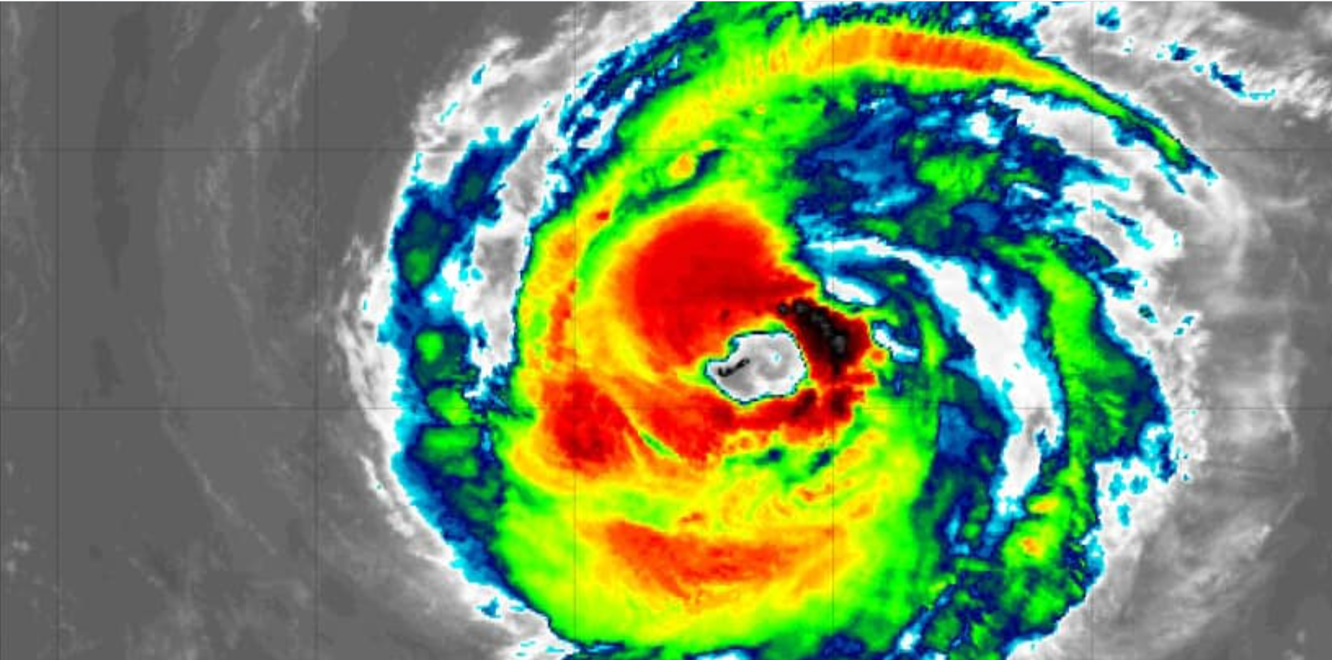
What a beautiful shot.
Credits can not be taken by myself, I took it from Puerto Rican Meteorologist Ada Monzon.
around 6AM this morning, Hurricane Paulette over Bermuda, with the Island completely in the eye of the Hurricane.
the eyewall powers battered Bermuda with 90mphrs winds.
as for Size:
Bermuda is 21 miles long and 2 miles wide, so Paulette's eye measures ca 40 miles of a diameter.
between tonight and tomorrow night the favorable conditions open a window for Paulette to become a Mayor Hurricane.
it will not threaten any other land than the just pased Bermuda.
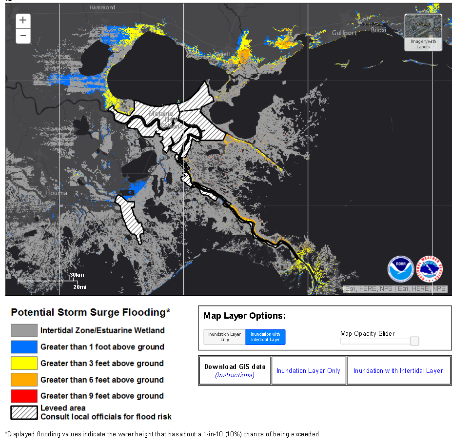
not our home land, but something on the edge for desaster:
Sally will very likely hit and heaviliest flood the Mississippi Delta.
this Map show's the forecasted flooding effects by the storm surge of to be Hurricane Sally.
TS Teddy is well organized and a power increasing Storm.
as awaited it will not come near us, but conditions and potential of ths system make it very likely to become the next Mayor Hurricane of this season,
it could reach the M-Cyclone Status as early as on Thursday night already, while far out on the NE of the Leeward Islands.
TS Vicky will be short lived as awaited and not be a threat to any land anymore.
we just started our 2020 peak time for hurricane season
and we are already on the edge to run out of names.
Conditions continue favorable for more to come, so this season a number of names need to be added to the list.
Credits can not be taken by myself, I took it from Puerto Rican Meteorologist Ada Monzon.
around 6AM this morning, Hurricane Paulette over Bermuda, with the Island completely in the eye of the Hurricane.
the eyewall powers battered Bermuda with 90mphrs winds.
as for Size:
Bermuda is 21 miles long and 2 miles wide, so Paulette's eye measures ca 40 miles of a diameter.
between tonight and tomorrow night the favorable conditions open a window for Paulette to become a Mayor Hurricane.
it will not threaten any other land than the just pased Bermuda.
not our home land, but something on the edge for desaster:
Sally will very likely hit and heaviliest flood the Mississippi Delta.
this Map show's the forecasted flooding effects by the storm surge of to be Hurricane Sally.
TS Teddy is well organized and a power increasing Storm.
as awaited it will not come near us, but conditions and potential of ths system make it very likely to become the next Mayor Hurricane of this season,
it could reach the M-Cyclone Status as early as on Thursday night already, while far out on the NE of the Leeward Islands.
TS Vicky will be short lived as awaited and not be a threat to any land anymore.
we just started our 2020 peak time for hurricane season
and we are already on the edge to run out of names.
Conditions continue favorable for more to come, so this season a number of names need to be added to the list.
It was only in 2005 that all the names for storms were used up and Greek alphabet letters had to be used. In that year, the DR was only affected by one Tropical Storm Alpha. Fingers crossed this year.
- Status
- Not open for further replies.


