
- Thread starter CFA123
- Start date
You are using an out of date browser. It may not display this or other websites correctly.
You should upgrade or use an alternative browser.
You should upgrade or use an alternative browser.
One, Two, Three Strikes?
- Status
- Not open for further replies.
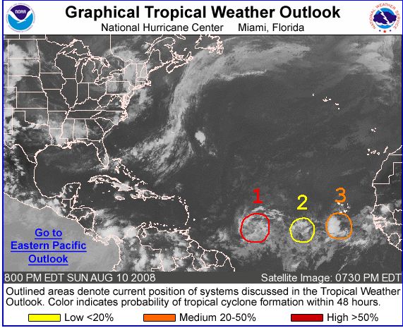
Yes indeed .. generally here as we are heading to middle of August, weather activity in our 'hurricane catchment area' is certainly picking up and the tropical waves are of a quality to develop the models fairly consistently. We should be seeing more of the pattern that CFA123 posted and stronger and quicker developing tropical waves. We're also seeing a fast rising NAO.
Things change quickly however and there are only 2 waves in the basin at the moment.
The area about 850 miles east of the windward islands look fairly calm this morning but it looks the best placed at the moment to develop further tropical storm characteristics.
So, by now I trust everyone has a hurricane preparedness plan in place?? aranoid:
Things change quickly however and there are only 2 waves in the basin at the moment.
The area about 850 miles east of the windward islands look fairly calm this morning but it looks the best placed at the moment to develop further tropical storm characteristics.
So, by now I trust everyone has a hurricane preparedness plan in place??
aranoid:The two systems out in the Atlantic both look as if they want to develop but both still need to pass an area of wind shear. So, we're watching both, but understand that there is still a long way to go for a tropical wave to become anything more than a wave.
We have an area of showers and thunderstorms developing in the Caribbean sea, southwest of the Dominican Republic. So far I cannot see that this system would influence us more than just a passing cloud perhaps carrying a few passing raindrops, but we are watching to see what it does.
We have an area of showers and thunderstorms developing in the Caribbean sea, southwest of the Dominican Republic. So far I cannot see that this system would influence us more than just a passing cloud perhaps carrying a few passing raindrops, but we are watching to see what it does.
Still not out of the woods with this low pressure system as of Wed night.
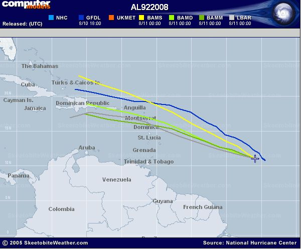
Atlantic Graphical Tropical Weather Outlook
Most recent projected paths put it passing over or just north of hispaniola. The big question remains how strong it will be at that time. Forecasters still don't seem to be in agreement. Hopefully it brings nothing more than a little rain and some cooler weather. But, worth keeping an eye on possible development.
Latest tracks available at Tropical Weather... Done Better!™
Wave Watching
We call this wave watching and we're way out of the woods as no-one has defined the woods or the trees yet. There are two or three waves generally at any one time during season in our hurricane 'catchment' area. Everything passes North or South of Hispaniola.
This wave, 92L continues to move generally west northwest and is disorganized. There is a lot of wind shear in that part of the ocean. It may develop further but more likely it will not. The models develop it, therefore we watch it. There is nothing yet on my personal radar that brings on the goose bumps :laugh:
We call this wave watching and we're way out of the woods as no-one has defined the woods or the trees yet. There are two or three waves generally at any one time during season in our hurricane 'catchment' area. Everything passes North or South of Hispaniola
.This wave, 92L continues to move generally west northwest and is disorganized. There is a lot of wind shear in that part of the ocean. It may develop further but more likely it will not. The models develop it, therefore we watch it.
There is nothing yet on my personal radar that brings on the goose bumps :laugh:sorry to disagree, but shear is basically none existent right now and will stay very low in the next days. The tropical low is over very warm waters now, convection is developing with increased inflow. If you check on storm forums all pro mets and computer models agree now that this is a developing system, and in such a now very favourable enviroment it <i>might</i> develop fast.
Track guidance is also now getting to the agreement that the system will be along or very near the north coast on Friday / Saturday as the ridge is very strong and won't let the system turn to the north much - not much time to prepare IF this system will strenghten fast.
I understand the 'do-not-scare-the-tourists' attitude, but denying a possible threat of a storm in just 2 or 3 days by posting incorrect information is just wrong IMO.
Code:
* ATLANTIC SHIPS INTENSITY FORECAST *
* GOES/OHC INPUT INCLUDED *
* INVEST AL922008 08/14/08 00 UTC *
TIME (HR) 0 6 12 18 24 36 48 60 72 84 96 108 120
SHEAR (KTS) 2 3 3 2 3 9 4 8 6 8 12 9 9
SST (C) 28.4 28.4 28.5 28.5 28.6 28.8 28.8 28.8 28.9 29.0 29.2 29.4 29.6
There is a lot of wind shear in that part of the ocean.
Maybe not any more. From 0000 UTC 08/14/2008 Detailed Atlantic Outlook 'Shear is currently low over the system but some dry air at some distance from the convectively active region can still damp intensification'
Tropical Outlooks
If it develops it could be soggy Saturday on the north coast. :cheeky:
Now I can sleep In comfort,
That's all.....Meryl is a great actress!
Forecasts now suggest 92L will become a depression later today & possibly a TS by the end of Friday. Hurricane hunters flying in to do a recce later today.
Caribbean Hurricane Network - stormCARIB.com - Local Reports on Tropical Systems threatening the Caribbean Islands
Caribbean Hurricane Network - stormCARIB.com - Local Reports on Tropical Systems threatening the Caribbean Islands
Forecasts now suggest 92L will become a depression later today & possibly a TS by the end of Friday. Hurricane hunters flying in to do a recce later today.
Caribbean Hurricane Network - stormCARIB.com - Local Reports on Tropical Systems threatening the Caribbean Islands
And the word is suggest.
Quaqualita, we will neither subscribe to a 'scare the tourist' methodology and neither will be subscribe to a mindless panicmongering methodology.
92L is still hardly a tropical wave. We do not have even a tropical depression yet. Bear this in mind. Because there is a line on a chart, does not mean we need to panic. What it means is that we have to understand the following...
A tropical low may have tropical wave characteristics and develop into a tropical wave. Thereafter, we get a tropical depression, thereafter a storm and thereafter a hurricane. We are still in a tropical wave phase and this system has characteristics as if it wants to develop. Over Hispaniola, we can expect tropical rains and winds over the next day or two, with the typical dangers around tropical rains and winds ... mudslides and flooding.
So, let's kindly stop being histerical and ladies, please keep your panties on. The television weather commentators have nothing to talk about currently, so they will milk the weewee out of this one.
So, with 92L, we have a low pressure within a tropical wave. The models develop it currently to turn to the North before it reaches the US. The Bahamas should be watching this system very closely but those in the South East should not forget about it completely. It is early days. A recon aircraft will investigate the system later today. Again, it is extremely early days for systems such as this and we've seen about 25 to 30 (my rough estimate .. I don't count them) of them already this year. The models show that this one has a chance of developing.
Last edited:
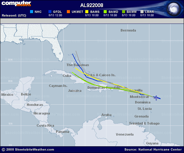
At the current pace the Dominican Republic North Coast and of course the East should see this system starting mid-morning on Friday. Development into a tropical depression will be very gradual based on all current model runs and assessments. This system may decide to develop faster and it truly looks impressive on the pics, but somehow I think it will take its sweet time about it.
I stress, currently it is a windy patch with rains and winds. The remainder of the Caribbean is calm with cooling easterly trades.
I stress, currently it is a windy patch with rains and winds. The remainder of the Caribbean is calm with cooling easterly trades.
From Jeff Masters Wunderblog: Wunder Blog : Weather Underground
...disturbance 92L appears poised to develop into a tropical depression today
...
After passing Puerto Rico on Friday, 92L is expected to move along the north coast of the Dominican Republic on Saturday.
...
The storm will probably will not have time to grow beyond a 60 mph tropical storm by Saturday, when it could bring heavy rains of 4-8 inches to the northern Dominican Republic. These rains should spread to northern Haiti by Sunday, where heavy rain is always a threat to cause significant loss of life.
Not wishing to tempt fay.........I mean fate could I inquire if it is possible for a tropical wave to go straight to a tropical storm without a tropical depression being called in between? In other words while I do understand the progression
is it possible that if the official forecasts are slow to call OR the thing develops quickly, then we could jump a stage?
Hope this isn't too dumb a question from a pantyless, hysterical (????) amateur at this sort of thing.............:laugh::laugh::laugh:
could I inquire if it is possible for a tropical wave to go straight to a tropical storm without a tropical depression being called in between? In other words while I do understand the progression. What it means is that we have to understand the following...
A tropical low may have tropical wave characteristics and develop into a tropical wave. Thereafter, we get a tropical depression, thereafter a storm and thereafter a hurricane.
is it possible that if the official forecasts are slow to call OR the thing develops quickly, then we could jump a stage?
Hope this isn't too dumb a question from a pantyless, hysterical (????) amateur at this sort of thing.............:laugh::laugh::laugh:
Of course it is possible Lambada. Currently, using the actuals from the recon aircraft, we do not have a tropical depression yet. Yet, the system is prime for development. Usually though, the development is slow and discrete and distinct stages can be determined according to well developed scales. I have not seen a system storm 'skip a stage' yet. The stages though can be close together with fast developing systems.
Quaqualita, Jeff Masters has the same information than any other weather reporter on this 'developing story'. In addition, he is most possibly party to regularly scheduled telephone conferences. Currently he is certainly blowing some hot air and milking the possibilities which is excellent for his own exposure.
Yes, this system could develop and cause havoc. But we have to wait until it becomes a little more than a 'tropical disturbance' before we push any panic buttons. This collection of rains and clouds and winds is currently called a 'tropical disturbance' in all of the official documentation. And this is after a physical recon as well as before Puerto Rico. If the NHC wants to get Puerto Rico to move and put preparedness plans into quick operation, I've seen them call a tropical storm early. Currently, they have not done so. Perhaps they do so overnight.
This disturbance could bring heavy rains to Hispaniola with all the related issues like mudslides and raging rivers and some flooding in low lying areas. But it is not going to blow anyone's house away at this stage of the game.
TROPICAL WAVE IS IN THE W TROPICAL ATLC/E CARIBBEAN ALONG
61W/62W WITH A 1009 MB LOW ALONG THE WAVE NEAR 18N MOVING W
10-15 KT. WHILE THE ASSOCIATED THUNDERSTORM ACTIVITY HAS BECOME
MORE CONCENTRATED...MOST OF THE ACTIVITY IS LOCATED WELL EAST OF
THE LOW CENTER AT THIS TIME. SCATTERED MODERATE/STRONG
CONVECTION IS E OF THE LOW CENTER FROM 16N-19N BETWEEN 60W-62W
WITH SCATTERED MODERATE/ ISOLATED STRONG CONVECTION N OF THE LOW
CENTER WITHIN 45 NM OF LINE FROM 20N59W 21N61W TO 20N63W. NOAA
AND AIR FORCE RESERVE HURRICANE HUNTER AIRCRAFT ARE CURRENTLY
INVESTIGATING THE SYSTEM TO SEE IF A TROPICAL DEPRESSION HAS
FORMED. REGARDLESS OF DEVELOPMENT...THIS SYSTEM COULD BRING
LOCALLY HEAVY RAINS AND GUSTY WINDS TO PORTIONS OF THE N
LEEWARD/VIRGIN ISLANDS...PUERTO RICO...AND HISPANIOLA DURING THE
NEXT DAY OR TWO.
Last edited:
Let's wait for the Data Dammit!
I never look at the various weather forecasts during hurricane season. These folks usually confuse me mightily. But while I was thinking of what to say to quaqualita, I had a quick look at weather dot com and found this excellent example of a 'blowing smoke' headline ..
-------------------
Tropical System Continues To Develop
Hurricane Hunters did not find a tropical depression near the Lesser Antilles.
--------------------
So, there is no tropical depression yet .. but instead of reporting that, the headline is written more provocatively.
Chris,
You're correct... there's not a declared tropical depression, storm, hurricane out there yet - and 92L might not become one.
Perhaps I'm reading them incorrectly, but your posts seem to be downplaying it all. However, some of the current models still show (now as they did yesterday) 50-60 mph winds approaching north DR coast Friday night/Saturday morning. Sure, these are computer models with all the potential flaws associated with the different methodologies. This thing can fizzle, or it could be a strong tropical storm in 24 hours. Or it can take a turn away from DR. We don't know.
Last Sunday when I posted, it was a curiousity. Now, that this 'possibility' is only 24-36 hours away, it seems worth discussing for those with north coast interests. However, you seem to prefer we stay quiet until such time as NHC may have to say it is a tropical storm.
Is that your preference in this forum, even if that means people wake up tomorrow morning (or with some other storm in the future) with 10 hours of daylight to do whatever preparation they desire?
Now, that this 'possibility' is only 24-36 hours away
Or less actually, according to Derek Ortt 'the area of low-pressure is expected to move over Puerto Rico this evening and over the Dominican Republic during the day tomorrow' emboldening mine
Tropical Disturbance Statement
Derek Ortt was the guy who was right about Noel last year when DR Met was downplaying it.
- Status
- Not open for further replies.