
The forecast for most of the Dominican Republic is intense summer heat made worse by clouds of Sahara Dust. A passing trough will bring showers and possible thundershowers in areas of the northeast, southeast and the Central Mountain Range, reports the National Meteorological Office (Onamet).
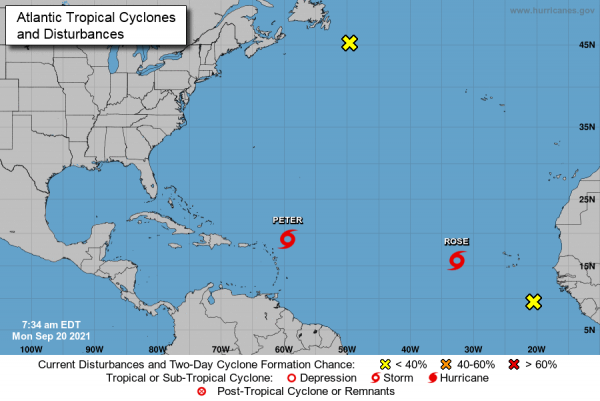
Onamet is monitoring Tropical Storm Peter that is expected to pass north of the Leeward Islands in the Caribbean. The storm is moving west/northwest and is expected to move away from the Caribbean.
Weather authorities are monitoring the storms that are developing off Africa to see how they may impact the island. Reports are that Tropical Storm Peter is unlikely to affect the Dominican Republic as it has a northern direction, but that it could bring rain and high surf. It is forecast to pass well north of Puerto Plata on Wednesday, 22 September.
Another phenomenon, Tropical Storm Rose is developing over the eastern Atlantic. The storm is not a threat to land in the Caribbean as it is also moving north into cooler waters. September is the peak month for hurricanes in the Caribbean, and all eyes are on the storms that may develop off the African coasts.
Once the storms offer a threat to the Dominican Republic, DR1 weather expert MikeFisher provides timely updates.
MikeFisher reported on Sunday, 19 September: “While the “Map” may look scary to some, there is absolutely nothing out there that could be considered any danger for DR. TS Peter will miss the island far out, TD17 [Rose] is moving northwards. For the next “Dot on the Map,” that disturbance is still over land over western Africa and has first to form a storm, before speculations can start about anything. So far, at this moment, absolutely nothing bad in sight.”
Read more:
Onamet
DR1 2021 Hurricane Season updates
20 September 2021