
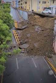
Provinces in the central Cibao area, mainly Santiago, suffered from the effects of a passing tropical wave on Tuesday, 16 August 2022. The bridge at the Calle 30 de Marzo corner Las Carreras was affected and the heavy rains flooded the streets in Santiago.
The Weather Office (Onamet) forecasts the tropical wave is moving away. However, Onamet states that the trough and local effects of daytime heating will continue to generate clouds after noon with moderate to heavy downpours, thunderstorms and wind gusts mainly towards locations in the north, northeast, the eastern plains, the Central Mountain Range and the border area.
The Center for Emergency Operations (COE), in turn forecasts heavy rains for Santiago Rodríguez, Santiago, La Vega, El Seibo provinces. It placed Puerto Plata, Valverde, Espaillat, Dajabon, Sánchez Ramírez, Monseñor Nouel, San Jose de Ocoa, Monte Plata, Hato Mayor and La Altagracia provinces under green alert for rains and possible flooding, too.
The forecast is also for intense hot summer temperatures for now through September. Listin Diario reports people are congregating in city parks to seek respite from the summer heat.
Read more in Spanish:
Onamet
Center for Emergency Operations
Hoy
17 August 2022