
Weather researchers have been warning for months that the 2024 Atlantic hurricane season will bring big storms, and it is happening. Hurricane Beryl is an atypical storm forming so early in the year. The last time this happened was in 1933.
The Dominican Republic is not directly in the path of today Hurricane Beryl. Nevertheless, President Luis Abinader convened the emergency committee to be in permanent session. The provinces with Caribbean coasts are now under green alert or yellow alert. Greater Santo Domingo (National District and Santo Domingo), San Pedro de Macoris, La Romana and La Altagracia are under green alert, while the southwestern provinces of Pedernales, Barahona, Azua, Peravia and San Cristobal are under yellow alert.
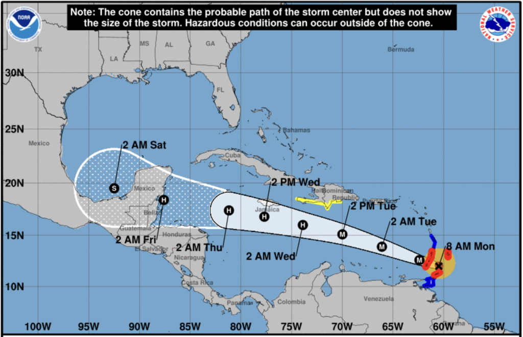
Category 4 storm Hurricane Beryl is making its way westward and on Monday, 1 July 2024 was already located near 11.5 N 58.1W with winds of 132 mph (212 kph). This is the first time a category 4 storm happens so early during the season. The DR is on green alert with a probability for tropical storm impact 50% in about two days. David is the worst hurricane to have hit the Dominican Republic with winds of 282 kph when it hit on 29 August 1979.
The changeable nature of storms has the nation now on alert. In addition to Beryl, weather forecasters alert there is another system tracking right behind and also making its way towards the Caribbean
Historically speaking, the month of June is generally quiet as far as tropical storms and hurricanes go. The average for June is just one named tropical storm. This year, which has been predicted to be a “very active” year for tropical storms and hurricanes, is now welcoming its second tropical storm, Beryl, which on Saturday evening (29 June 2024) began its life as the second named storm of the 2024 hurricane season, and the first hurricane of the year.
Beryl is currently east of the Windward Islands of the Caribbean, and heading for Barbados, St. Vincent and the Grenadines, and St. Lucia and threatens these with Hurricane 4 strength as the storm moves over hot waters.
NHC reports Beryl is expected to pass south of Puerto Rico and the Dominican Republic, with some indirect effects of rain and dangerous surf. The country prepares for flooding.
According to Gloria Ceballos, of the Dominican Meteorology Office (Onamet), the center of the hurricane is not, at this time, being computed to make landfall on the island of Hispaniola (Haiti and the Dominican Republic). The southwestern corner of the Dominican Republic remains within the cone of uncertainty, so the country is paying attention to any changes in the forecast. The storm will be in the southwestern peninsula area by Thursday.
Ceballos calls for close monitoring of the storm’s path as it moves west into the Caribbean given the fickle history of many hurricanes. Everyone’s hurricane preparations should be in place.
The outer bands of wind and rain are expected to begin affecting the southern coast of the Dominican Republic late on Tuesday and into Wednesday. Normal precautions, as posted on DR1.com are advised.
Mike Fisher for DR1 Weather on the DR1 Forums is joining the weather reporting with his singular reports for DR1 that summarize and bring home what is happening.
Mike Fisher writes in his update on Sunday, 30 June:
“Hurricane Beryl is an almost perfect built power machine, not missing much to reach the top of the scale for storm powers.
“Waking over the Winward Islands tomorrow morning will not be a walk in the park for the people there, as Beryl will be a Cat4 Hurricane with destructive wind force, aside from the usual dangerous storm surge pushed around.
“On its way through the Caribbean Sea there are no indicators of any bad conditions that could knock down such storm, so we should expect it to be a destructive Mayor Hurricane all the way through until it is past DR and Jamaica.
“So far the Atlantic High Pressure Ridges are stable and protect us from any powers coming from our South to us. If that stays the same stable for the next three days, which I expect, then Beryl will continue to run on its high forward seed of ca 20mphr tomorrow morning over the Windward Islands, a quick in and out, a hit&run. Let’s hope for the folks there to get lucky and not touch this eyewall.
“By Wednesday morning, the Eye will already be passed DR, a quick run without further hits straight into Belize/Mexico, the Yucatan Peninsula.”
Yet: bottom line, Mike Fisher stresses the importance to be prepared: “While ya never know what could happen the next moment on such things, It looks like we will all stay safe from the destructive center forces of Beryl, a quick in and out far south of DR moving E to W on around 20mphr Monday Through Wednesday, then starting to loose some powers little by little on the final 48hrs approaching land.”
Read more:
Onamet
Noticias SIN
DR1 Weather
Diario Libre
N Digital
Listin Diario
Diario Libre
Diario Libre
NHC
NHC
Mr Weatherman
Hurricane Info
El Dia
El Caribe
Jean Suriel
Hoy
1 July 2024