
There were reports of intense rains in mountain areas, namely central Constanza, but for the most part, the Dominican Republic was spared the impact of Beryl.
AES Dominicana reported that its AES Andrés generator plant and natural gas installations, located on Punta Caucedo in Santo Domingo province, were impacted due to the debris the crashing high waves delivered. The company reported a temporary reduction in its supply of natural gas-fired energy to the national grid. AES Dominicana reported efforts are ongoing to return the units to normalize operations in the shortest time.
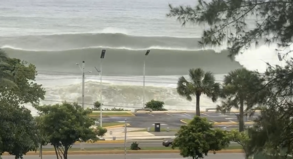
In Santo Domingo, there was a burst of intense rain for around 15 minutes. The huge surf on the Malecon was the story. The waves made for a spectacle of nature on the coastal boulevard and the authorities were criticized for not stopping traffic and people’s entry earlier, leaving many to risk their lives for a selfie or vehicles to be destroyed by rocks and debris coming with the enormous waves. It was not until around 4pm that the authorities closed the coastal roads – Malecon and Avenida España that border the coast.
For the most part, the passing storm did not disrupt life in Santo Domingo. Beryl passed about 330 kms from the capital city. Onamet had forecast waves of 9 to 15 feet and urged people to stay away from the coastline.
The waves came with rocks and the lives of those crossing was endangered, as social media videos evidenced. The waves caused damage to the maritime park built by the Santo Domingo city government.
The storm brought some rain, but nothing out of the ordinary in the capital city. Reports from Barahona and Polo farms is the same. The Barahona and Pedernales region in the Southwest was to be the worst hit as it is the most southern coast of the country. There were reports of some flooding onto the Barahona Malecon, that would soon resolve.
The storm passed as a Hurricane 5 storm with winds of more than 250 kph. Weather forecasters have called unprecedented that a Hurricane 5 in June-July, a call of alert to what could be coming as the season unfolds. Usually, big storms happen in September.
Beryl is described as an unprecedented storm but forecasters say the high temperatures in the Caribbean Sea, worsened by the cyclical presence of La Niña, creates the conditions in place for the repeat similar situations. On Friday, 28 June 2024, tropical depression Beryl was first reported making its way towards the Caribbean. By Sunday, it was a hurricane, breaking the record in the Caribbean for the time it took for a major storm to develop. Beryl was the earliest storm to become a Category 4 storm, with sustained winds of 209-251 kph. Beryl also broke the record of speed in becoming a Category 5 storm.
Beryl also proved the fickleness of storms. All computer models had shown it would be a direct hit on Jamaica. Now, Beryl is tracking further south, which should reduce the impact of fierce winds and driving rain on that western island.
Scientists are predicting an active 2024 Atlantic Hurricane Season, and Beryl embodies this reality. The forecast is for eight to 13 hurricanes with devastating winds of upwards of 120 kph.
The forecast is for four to seven of the projected hurricanes to reach Category 3. Beryl reached Category 5.
Beryl so far devastated the tiny island of Carriacou island, Grenada. Beryl message is to be prepared for the worst.
Read more:
Listin Diario
Listin Diario
El Dia
Hoy
Hoy
Hoy
N Digital
N Digital
Noticias SIN
Cyclocane
3 July 2024