
The Abinader administration recently announced millions have been spent for a modern radar (C-Band Solid-State Dual-Polarization Doppler Radar) installed at Las Americas International Airport (SDQ) to enhance private aviation security and the safety of those in the Greater Santo Domingo and the southcentral region.
Yes, Santo Domingo now has its own weather radar, but apparently, the people at the Dominican Institute of Meteorology (Indomet) do not have the training to read the data and alert the population in a timely way. There is a difference between scattered rains and intense downpours that call for special preventive actions. The details in the data provided by the radar enable experienced weather forecasters to tell the difference.
On 7 April 2026, the National Meteorological Institute (Indomet) issued its usual daily weather forecast indicating that a trough would be moving our way bringing rain. Greater Santo Domingo was given a green alert.
Indomet had stated the passing trough would bring heavy rains on Tuesday and Wednesday and weather would improve by Thursday. Neither the weather forecast nor the Center of Emergency Operation authorities gave a sense of urgency. Troughs happen all the time.
There are troughs and there are troughs.
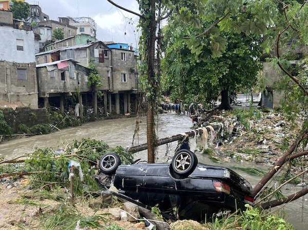
The rains began in the first hours of 8 April 2026 when people had gone to sleep. People awoke in Greater Santo Domingo to flooding waters. Many of those who left for work in the early morning had to abandon their vehicles to the gushing waters. Metro users report gushing waters flowing down the stairs. Fortunately, the drainage at the bottom of the metro worked.
Drainage in the city over the years has been impacted by over construction. Concrete has replaced the patios where waters drained. Poor people build on “free land” where they should not build, ignoring that gullies and river waters can return to their original courses. Climate change has worsened this reality, impacting constructions even in upscale areas.
After the damages by gushing and flooding waters had been done, weather expert Francisco Holguin criticized the local authorities, especially those at the Center for Emergency Operations (COE). He said the authorities underestimated the weather event and failed to issue timely alerts.
“The authorities rested on their laurels,” he stated, noting that as early as 1am, meteorological radars were already showing significant precipitation clusters over Santo Domingo West, the National District, and parts of San Cristóbal.
Holguín maintained that while the exact magnitude of the rainfall was not predicted, there were sufficient conditions to anticipate a significant event. He argued that alerts should have been issued in the early morning hours, advising the population to remain at home.
By 3am, he asserted, the responsible institutions should have been coordinating preventive actions, and by 5am at the latest, the public should have been informed via mass communication about the imminent risk.
Weather forecaster of the CDN, Jean Suriel on his Instagram account wrote in his early morning analysis that the amount of rainfall that fell on the first hours of 8 April was comparable to that impacting on 4 November 2022 and 18 November 2023, two memorable days for those living in Greater Santo Domingo.
Suriel explained that five distinct atmospheric factors converged to produce over eight consecutive hours of torrential downpours.
According to meteorologist Jean Suriel, the extreme flooding was caused by a combination of a strengthened trough, abundant marine moisture, warm air from the Caribbean Sea, the proximity of cold front number 35, and the development of a low-pressure system north of the Caribbean.
In his unofficial report, Suriel said Santo Domingo had experienced heavy rainfall accompanied by lightning and wind gusts during the early morning hours with 408 mm of accumulated rainfall in the first hours of 8 April. This compares to 431 mm of accumulated rainfall on 18 November 2023 and 267 mm in 24 hours on 4 November 2022.
Suriel emphasized that these torrential rains and extreme flooding events are becoming more frequent due to the effects of climate change. Higher sea surface temperatures and increased atmospheric water vapor are primary drivers of the intensifying weather patterns in the region.
In the early morning, the Ministry of Education suspended classes and the government urged all who could telework to do so.
Media reports and social media carried remarks that the sky was mourning the deaths of the 236 persons who had died when at 12:44am at the Jet Set Club the roof collapsed in 2025.
Dozens of commuters had to flee their cars when the gushing rain waters were more than they could handle. Many families and businesses awoke to major damages by the intense rains and flooding.
President Luis Abinader called a press conference at the Center for Emergency Operations. Capital city mayor Carolina Mejia was present. Chief meteorologist Gloria Ceballos was not on the presiding table to answer questions. The President said that the social assistance entities of the government would be working overtime to assist those who had lost their belongings.
In the press conference, the director of the Center of Emergency Operations, retired General Juan Manuel Méndez argued that nothing could have been done given the intense rain that fell in such a short time. He said the rainfall exceeded the response capacity of any urban system.
Mendez said the most impacted areas were the National District, Santo Domingo West, Los Alcarrizos, Pedro Brand and Santo Domingo North.
He detailed that, according to data validated by the Presidency, the weather station at INTEC (Instituto Tecnológico de Santo Domingo) recorded accumulations were between 300 mm and 400 mm of rain, a figure he described as extraordinary.
In this regard, Méndez emphasized that neither the terrain nor the existing drainage systems are prepared to manage such a high volume of water within such a short window of time.
As reported in Acento, General Juan Manuel Méndez, director of the Emergency Operations Center (COE), issued a sharp, detailed rebuttal to critics questioning the agency’s handling of recent heavy rainfall alerts. During the press briefing, Méndez defended institutional protocols and pushed back against mounting public scrutiny, emphasizing that the COE’s actions are strictly governed by technical data.
“I am going to expand on this explanation… so that we can understand each other,” Méndez stated in a stern tone, signaling a formal “call to order” for his detractors, as reported in Acento. Mendez would clarify that the COE does not operate in a vacuum but functions as a coordinating body for scientific entities, including the Dominican Institute of Meteorology (Indomet) and the National Geological Service.
The retired general stressed that the COE is legally and operationally bound by the bulletins issued by meteorological experts. He pointed out that the decision to escalate alert levels, such as moving from yellow to red, is dictated by specific rainfall measurements provided by these technical agencies. According to Méndez, the COE cannot unilaterally heighten alerts without the requisite technical backing from the nation’s scientific monitoring bodies.
There is a general consensus that losses would have been less if people had been given an early warning. The reality is the Dominican Republic is an island subject to tropical weather. The country now has the technology to at least alert the population to take special prevention measures.
The reasoning for the installation of the radar was to bolster aviation safety by allowing controllers to steer aircraft away from severe turbulence, wind shear, and convective storms. Beyond the airport’s immediate operations, the radar was also purchased to serve as a critical tool for the country’s national early warning system, helping to predict flash flooding and storm intensity for the Greater Santo Domingo area, with the most population, and the southcentral region of the Dominican Republic.
The new C-Band Solid-State Dual-Polarization Doppler radar at Las Américas International Airport (AILA) significantly upgraded on paper the Dominican Republic’s ability to prevent disaster through high-precision “nowcasting.” The importance of this system lies in its ability to transform raw weather data into actionable life-saving alerts.
The radar’s advanced technology addresses the two biggest challenges in flood prevention: knowing exactly how much rain is falling and knowing exactly where it will hit. Its tech specs indicate it has:
Dual-Polarization (2D Scanning): Unlike older 1D radars, this system sends both horizontal and vertical pulses to measure the size and shape of raindrops. This allows meteorologists to distinguish between heavy tropical downpours and lighter rain, leading to much more accurate rain forecasts (QPE).
Debris & Particle Identification: The system can “see” the difference between rain, hail, and non-weather objects (like birds or debris). By identifying the specific type of precipitation, authorities can predict the weight and impact of water entering local river basins.
Real-Time “Nowcasting”: Because the system is Solid-State, it remains in a constant state of readiness with no warm-up time. It provides high-resolution data updates every few minutes, giving civil defense and airport authorities a critical “lead time” to issue evacuation orders or ground flights before flash flooding begins.
The new Doppler radar has a coverage radius of 250 kilometers, significantly extending the surveillance reach for incoming weather patterns.
The system provides real-time updates on atmospheric conditions, specifically tracking the movement and intensity of rain, wind speed, and wind direction with high resolution.
The data is shared directly with the National Meteorological Institute (Indomet) and integrated into the Air Traffic Control (ATC) systems to provide pilots and controllers with precise “nowcasting” capabilities.
Furthermore, the radar system is a primary engine for Early Warning Systems (EWS) because of its “Nowcasting” precision that can calculate rainfall volume with much higher accuracy than single-pol radars. This is critical for predicting flash floods in the mountainous terrain surrounding Santo Domingo.
The system Hydrometeor Classification technology of the system automatically categorizes targets into rain, snow, hail, or “biologicals.” This enables the issuing specific hail or heavy rain alerts before the weather hits.
By noon of Wednesday, 8 April the sun was again shining in Santo Domingo. The weather is forecast to improve on Thursday, 9 April 2026.
Read more:
Presidency
Jean Suriel Instagram
El Nacional
El Nacional
El Nacional
El Nacional
El Nacional
Noticias SIN
Noticias SIN
Noticias SIN
Listin Diario
Acento
El Dia
El Dia
DR1 News
9 April 2026