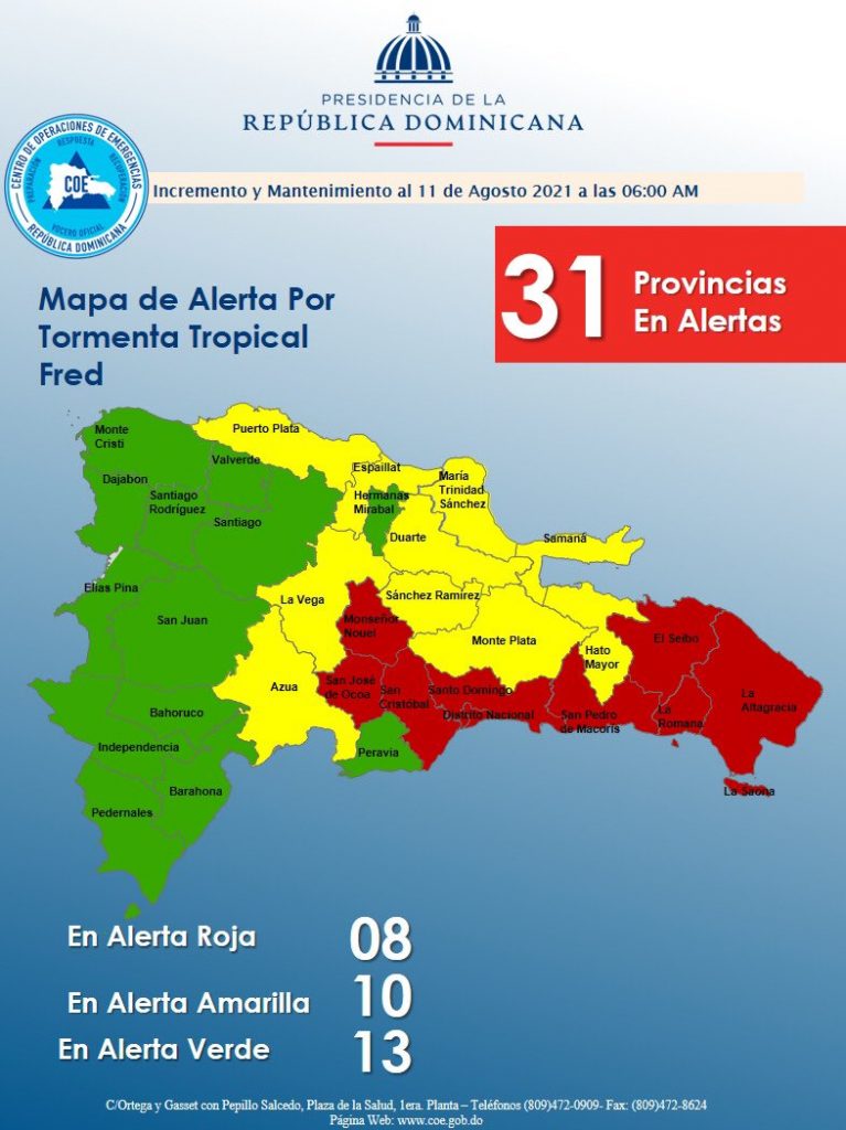
The Center for Emergency Operations (COE) expects heavy rains will cause flooding, mudslides and damages to property in the Dominican Republic as Tropical Storm Fred pummels through. The storm is crossing through the Dominican Republic on Wednesday, 11 August 2021 with most effects expected in the east, southeast and northeast. The COE has issued red, green and yellow alerts for 23 of 32 provinces, including the capital city.
The COE forecasts heavy rains and flooding for the eastern region, northeast, Greater Santo Domingo and Central Mountain Range on Wednesday, 11 August 2021. The storm is expected to have exited by the evening of Wednesday. The storm is moving at a good pace of 28km/h or 17mph. Maximum sustained winds are said to reach 65 km/h) with some higher gusts.
The provinces under red alert are: La Altagracia, La Romana, Santo Domingo, San Pedro de Macorís, El Seibo, San Cristóbal, Monseñor Nouel and San José de Ocoa. Red alert means there is a high probability the area will be impacted with the most damage to be experienced.
Provinces under yellow alerts are: Duarte, Samaná, Monte Plata, Puerto Plata, Espaillat, La Vega, Sánchez Ramírez, Hato Mayor and María Trinidad Sánchez. A yellow alert is issued to draw attention and get the population to take preventive measures to avoid water and wind damages. It means the arrival of the storm is imminent.
Santiago, Montecristi, Santiago Rodríguez, Hermanas Mirabal, Dajabón, Peravia and Valverde are on green alert. The population should continue monitoring the storm, yet impact will be minimum.
The Onamet has changed the Tropical Storm Watch for a Tropical Storm Warning for the north coast of the Dominican Republic from Cabo Frances Viejo to the Dominican Republic/Haiti border. The authorities say that the impact of the storm is to be felt from Punta Palenque in the east to the northern border with Haiti.
As of the 5am report of the US National Hurricane Center, the center of Tropical Storm Fred was located near latitude 18.0 North, longitude 68.2 West.
NHC advisory reports: “Fred is moving toward the west-northwest near 16 mph (26 km/h), and a general west-northwestward motion is expected to begin later today and continue for the next few days. On the forecast track, the center of Fred is expected to be near or over Hispaniola later today, move near the Turks and Caicos Islands and the southeastern Bahamas on Thursday, and move north of the northern coast of central Cuba on Friday.
Maximum sustained winds are near 40 mph (65 km/h) with higher gusts. Some weakening is likely while the system interacts with Hispaniola later today.
Tropical-storm-force winds extend outward up to 45 miles (75 km) from the center.
The estimated minimum central pressure is 1009 mb (29.80 inches).”
Read more:
NHC
Diario Libre
COE
El Nacional
Noticias SIN
DR1 Hurricane Season 2021 thread
11 August 2021

