
President Luis Abinader called work and school off and ordered most Dominicans in the capital city and provinces under red alert to stay at home on Thursday, 23 October 2025 following recommendations from the Center for Emergency Operations (Coe) and the Weather Institute (Indomet). He authorized that only gas stations, supermarkets and essential services remain open to 10pm in Greater Santo Domingo and the seven provinces.
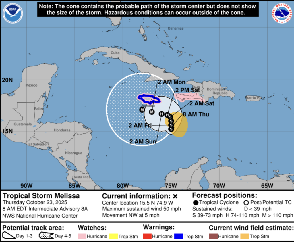
The main concern is that the outerbands of Tropical Storm Melissa will continue to bring consistent rains that may cause urban flooding. The storm is practically stationary, moving at 2-4 km per hour and is more than 400 km to the south of the southwesternmost point of the Dominican Republic on the channel between Haiti and Jamaica.
Essential services allowed to remain open in red alert areas are supermarkets, clinics, corner grocery stores, gas stations, power and telecom companies, security operations and pharmacies.
The President and Vice President are leading the inter-institutional commission that is monitoring the situation on a day-to-day base and have nightly recommendations for the next day. The recommendation for Thursday, 23 October is for people to stay at home for safety reasons in red alert areas.
The red alert areas are: National District and Santo Domingo province (Greater Santo Domingo) and the provinces of San Cristóbal, Peravia (Bani), San José de Ocoa, Azua, San Juan de la Maguana, Barahona and Pedernales.
Provinces under yellow alert are: La Vega, La Romana, Hato Mayor, El Seibo, Samaná, San Pedro de Macorís, Monseñor Nouel, Sánchez Ramírez, La Altagracia, Elías Piña, Monte Plata, Independencia and Bahoruco.
Mike Fisher for DR1 Weather reports the storm is almost stationary. He says that schools will be open in Punta Cana and in other provinces not on red alert.
For Punta Cana, Mike Fisher reports completely calm conditions, zero wind and no rain. He expects only light rains early on and zero water the rest of the day. He says Tropical Storm Melissa keeps her path and each forecast update is bringing it more west and there is no danger for the Dominican Republic aside from the possibility of up to a maximum of 12 inches of rain over three days and just for the southwest part of the DR. Yet he points out with Tropical Storm Melissa nothing is written in stone.
In the capital city, a red alert area, it rained on and off all yesterday and more of the same this early morning. Traffic was intense on Wednesday afternoon as everyone seemed to be going home or to the supermarkets that were packed, with all going still in the evening. No traffic this early morning. Light rains continue this Thursday morning.
The capital city does not have adequate drainage. Mayor Carolina Mejia administration authorized the largest expansion of high rises in the city of all times, not taking into account the threat or worsening urban flooding. Many of the high rises have gone up in areas where city planning had not allowed them. The construction of high rises on property where there were single homes with patios and trees has put the capital city under the threat of serious urban flooding when it rains. The capital city is now paying the price. News services have been reporting on urban flooding incidents.
The US NHC says in its 5am report: One thing we feel confident about is that Melissa is likely to move slowly and remain in the vicinity of Haiti, Jamaica, and eastern Cuba for several days.
NHC explains that the current westerly vertical wind shear over Melissa is expected to linger for about another day, and that should keep the storm at around the same intensity during that time. However, after that, the upper-level wind pattern will gradually become more conducive while the system remains over the very warm waters of the central and northwestern Caribbean Sea. These conditions should allow Melissa to become vertically aligned and strengthen significantly.
In fact, rapid intensification appears likely this weekend and early next week. The NHC intensity forecast lies near the middle of the guidance envelope from 12 to 72 hours, but leans toward the upper end of the guidance at days 4 and 5. As Melissa intensifies, its wind field is expected to grow and become more symmetric.
Melissa is expected to meander over the central Caribbean Sea for several days and is forecast to become a major hurricane by late this weekend or early next week. Interests in Jamaica, Haiti, Cuba, and the Dominican Republic are urged to continue monitoring the latest forecasts.
Due to Melissa’s slow motion, the risk of a prolonged period of strong winds, possibly lasting for a day or more, is increasing for Jamaica and the Tiburon peninsula of Haiti. Preparations to protect life and property should be rushed to completion, since strong winds could begin in these areas on Friday and continue increasing over the weekend.
Melissa is expected to produce heavy rainfall across portions of the Dominican Republic, Haiti, and Jamaica through the weekend, bringing a risk of significant, life-threatening flash flooding and numerous landslides.
Read more:
Presidency
Indomet
El Caribe
Noticias SIN
Noticias SIN
Noticias SIN
Noticias SIN
N Digital
N Digital
CDN
Diario Libre
23 October 2025