
I haven't seen the River Magajita lately so I won't comment on the veracity of that. The pictures Pichardo posted are Barrick's propagandda pictures. Here's my first hand testimony...Barrick is using up to 25000 gallons of water a minute off Hatillo Lake. They're quickly depleting the lake at very high pace. Here's a picture I took this past December.

See those cement walls? About two years ago the water was about half way up that wall.
Here's another one.

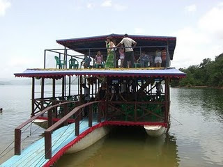
This part where there's now a road was all covered with water. The water used to be up to the tree line in the background. As a matter of fact right where I stood to take the picture is where the "Ferry Boat" used to be anchored. You can see it in this older picture.
Your first photograph is very deceiving.
I used to be a regular visitor to the Presa de Hatillo and my last visit would have been over two years ago.
Your first photo was a clear memory and to be seen on the right as one passed the dam and headed to the small jetty with a couple of bars. It was the old dam concrete dam across the old river bed of the Rio Yuna. The actual dam to the lake is an earthfill dam and looking upstream you se an earth embankment with road along the top.....a road upon I have often parked my car and admired the view.
This Google Earth link below confirms my memory and makes me wonder why you used the first photograph at all. A photograph taken from the road on the earthfill dam is all that is needed to show drops in lake levels.
https://www.google.com.do/maps/plac...0x8eaf8838def1b6f5:0xa6020f24060df7e0!6m1!1e1
I have little doubt that the lake will have suffered from the long drought we had up to the end of last year and your subsequent pictures suggest some level loss but nothing very dramatic, and I so am beginning to doubt your argument that Barrick have taken lake water and had any effect on water levels.
Last edited:
")