
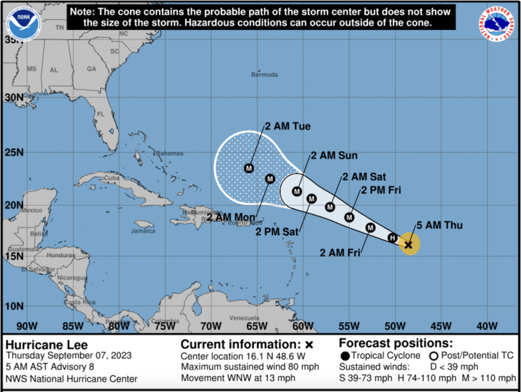
The National Hurricane Center of the United States reports that Tropical Storm Lee is getting more organized as it moves towards the Caribbean. Lee would be the fourth hurricane of the 2023 Atlantic hurricane season.
NHC says that Lee is forecast to become a major hurricane by early Saturday and could impact the northern Leeward Islands this weekend. While it is too soon to determine the location and magnitude of
these possible impacts, interests in this area should monitor the progress of Lee and further updates to the forecast.
NHC says that swells generated by Lee are expected to reach portions of the Lesser Antilles on Friday, and the British and US Virgin Islands and Puerto Rico this weekend. These swells are likely to cause life-threatening surf and rip current conditions.
The NHC reports that Lee has taken a northwestward course while the longer-term motion is still west-northwestward at about 12 kt. A mid-level ridge located to the north of Lee should continue to steer the cyclone on a west-northwestward heading through the weekend. The NHC reports that the dynamical model guidance continues to indicate that the core of Lee will pass to the north of the northern Leeward Islands, however, interests in those islands should continue to monitor the latest forecasts as the typical three-day NHC track error is about 90 n mi.
The light to moderate east-northeasterly shear over Lee is forecast to decrease overnight, and that, along with warm SSTs and a moist atmosphere along the forecast track, should allow for additional intensification. The NHC says the official forecast calls for a substantial 65-kt increase in strength during the next 72 hours.
Yet the NHC warns that by later in the weekend, hard-to-predict eyewall replacement cycles could cause some fluctuations in intensity.
Meanwhile, DR1 Weather forecaster MikeFisher reports:
“TS Lee continues its prior forecasted path and is building strong thunderstorm areas around the center area, meaning it is building an eyewall and will be named a hurricane any moment from now.
Conditions continue full supportive for quick intensifications, at this moment without any upper limit, so we will see a Mayor Hurricane well before it is close to the Leeward Islands and a full force running and growing Mayor Hurricane when passing N of PR and Hispaniola.”
MikeFisher stresses all eyes should be watching the path of the storm. “Such machine will bring strong wave action well ahead of reaching its closest point to any given area, so if you live on a beach area, do not get fooled by “arrival times of winds, etc. The surf will already be out of control many many hours before,” he reports.
His forecast: “While it is too early to tell exact direction, distance to land, final impact force of the surf, at this moment, we have to expect it to be very hard for the E and N shores of PR and the E and N shores of DR. At this moment I do not await that we will feel any wind forces, but such can not defined before the full running machine of a strong hurricane is up.”
He explains that the wind field of the storm will be seen on Saturday shots, when a better forecast can be made.
Yet he warns: “And keep always in mind that we are still on a long-range outlook, so everything including tracking, could change significantly, for the better or the far worst, either way possible.
The same goes for rainfalls, at this point I can not guess on which sides of the storm will carry the most and how much those would be or if we get anything more than what we would appreciate here on the campo as a welcome amount. We keep watching the updates every 6 hrs and hope for the best, as this one will grow fast and big, mother nature has so far zero conditions forecasted on its way that could bother the storm on its progress.”
Follow the storm:
NHC
DR1 Weather
El Nuevo Dia
7 September 2023