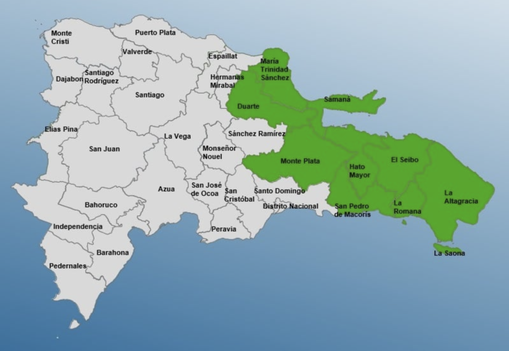
The Emergency Operations Center (COE) issued on Monday, 12 August 2024 a green alert for nine provinces in anticipation of the potential impacts of Tropical Storm Ernesto as it heads through the Caribbean. The storm is expected to swerve north when it arrives to Puerto Rican waters.
The government agency warned that from Wednesday to Thursday, the effects of Ernesto will bring moderate to very heavy rainfall at times, accompanied by thunderstorms and gusty winds, particularly to the northern, northeastern, eastern plain, central mountain range, and Caribbean coastal regions. These conditions are expected to gradually spread to other parts of the country throughout the day. Dangerous surf conditions will persist along the northeastern and eastern Atlantic coasts.
Given these forecasts, the COE has issued a green alert, warning of potential river, stream, and gully flooding, as well as flash flooding or urban flooding, for the following provinces: La Romana, María Trinidad Sánchez, Duarte, El Seibo, Samaná, Monte Plata, San Pedro de Macorís, La Altagracia, and Hato Mayor.
The National Meteorological Institute (Indomet) says that Tropical Storm Ernesto at 6am of Tuesday, 13 August 2024, was about 430 kilometers east-southeast of Antigua in the Lesser Antilles. Ernesto is packing maximum sustained winds of 65 kilometers per hour and is moving rapidly west-northwest at 44 kilometers per hour.
While a dry atmosphere and moderate Saharan dust concentrations will limit widespread rainfall across the country, yet a trough in the upper levels of the troposphere coupled with daytime heating are favorable conditions for localized heavy showers and isolated thunderstorms are expected over provinces in the northwest, north, eastern plain, Central Mountain Range, and the border region. Specifically, the provinces of Monte Plata, San Juan, Sánchez Ramírez, Monseñor Nouel, Monte Cristi, Dajabón, Elías Piña, and Santiago Rodríguez may experience these conditions.
Given the forecasted rainfall over the next 36 to 48 hours, the National Meteorological Institute has issued the weather alerts. Residents are advised to be cautious of potential river and stream flooding, as well as landslides and urban flooding.
In his update, DR1 Weather’s Mike Fisher reports at 6am on 13 August 2024 that Tropical Storm Ernesto has started to turn north and is now tracking W-WNW. By the evening, the direction is forecast to be NW, leading it to cross over the US Virgin Islands as a tropical storm.
Fisher writes that dry air and wind shear has kept the storm on a NW, so its wind field will stay small and extend out of the center solely towards the NE and E of the storm, leaving DR not just on a safe distance but also on the well-weaker side of a not powerful storm as it passes by.
Fisher says the DR will get rain: “Sure we can get some rainfalls out of such, even low-level storms can send rainbands out over quite a distance, so as usual the ones living in those 10 times per year flooded areas on our E and NE, should be prepared for water, but I do not see any catastrophic amounts to be collected while we are within its area of influence.”
He does forecast heavy wave action can be expected all along the DR East shores, yet no troubles for the southern and northern shorelines.
He explains Ernesto is expected to become a Hurricane Cat 1 force storm as early as Wednesday night, but that due to its high forward speed of at least 20mph, it will keep a safe distance and pass far north of Samana.
Read more:
DR1 Weather
Indomet
Hoy
El Caribe
NHC
13 August 2024

