- Thread starter Olly
- Start date
You are using an out of date browser. It may not display this or other websites correctly.
You should upgrade or use an alternative browser.
You should upgrade or use an alternative browser.
2020 Hurricane Season
- Status
- Not open for further replies.
I prefer at home XV, Leyenda, good Wisky.
on da road i refer greenies in the medium format, lol.
come on, you guys first feared the one mid highway, which had what, a 70% of chance to develop and a tracking towards the Leeward Islands accoring to NHC?
it is gone, zip, nada ...
the one which is still over Africa is not one, it is just some clouds over Western Africa, far from becomming anything.
once those clouds hit Tropical Atlantic Waters and get carried by a tropical wave over those waters AND come in touch with a surface low pressure system to form a real area of distrubed weather, THEN we can watch it for a couple days to fnd out if some development is going on there.
IF such is then the case, THEN we can start to run predictions on it.
BUT NOW:
we are on a nice calm weekend, with some light cloud cover and even some rainfall at some locations due a simple Frontal that alreaady passed and a undangerous Tropical Wave which is actually passing our south.
so the only common sense thing to do is to use the curfew shortened weekend hours as best as possible to have some FUN.
Oh Mike.... you'll be challenged on that....
by the regular amateur forecasters.....
Like the Boy Scouts --- always be prepared
Jesus H Christ -
we live in the tropics.... we ARE always prepared..... or SHOULD be
by the regular amateur forecasters.....
Like the Boy Scouts --- always be prepared
Jesus H Christ -
we live in the tropics.... we ARE always prepared..... or SHOULD be
there's no challenge, as i do not intend to outforecast anybody on anything.
I just give my own take and honestly do not care much about other's opinions on the same thing.
I solely go by my own opinion And of course appreciate the real fact actual weather reports from all other members here, located all around the Island.
that variety, with many members at all DR locations, make's our topic that valuable once a bad thing is close or wanders over us.
this weather topic is a simple easy to understand Dictatorship.
what I typeis the Holy Bible of the Tropics, the ones who disagree get deleted and are forced to post in Weather Hell/on a Whatsapp group, lol.
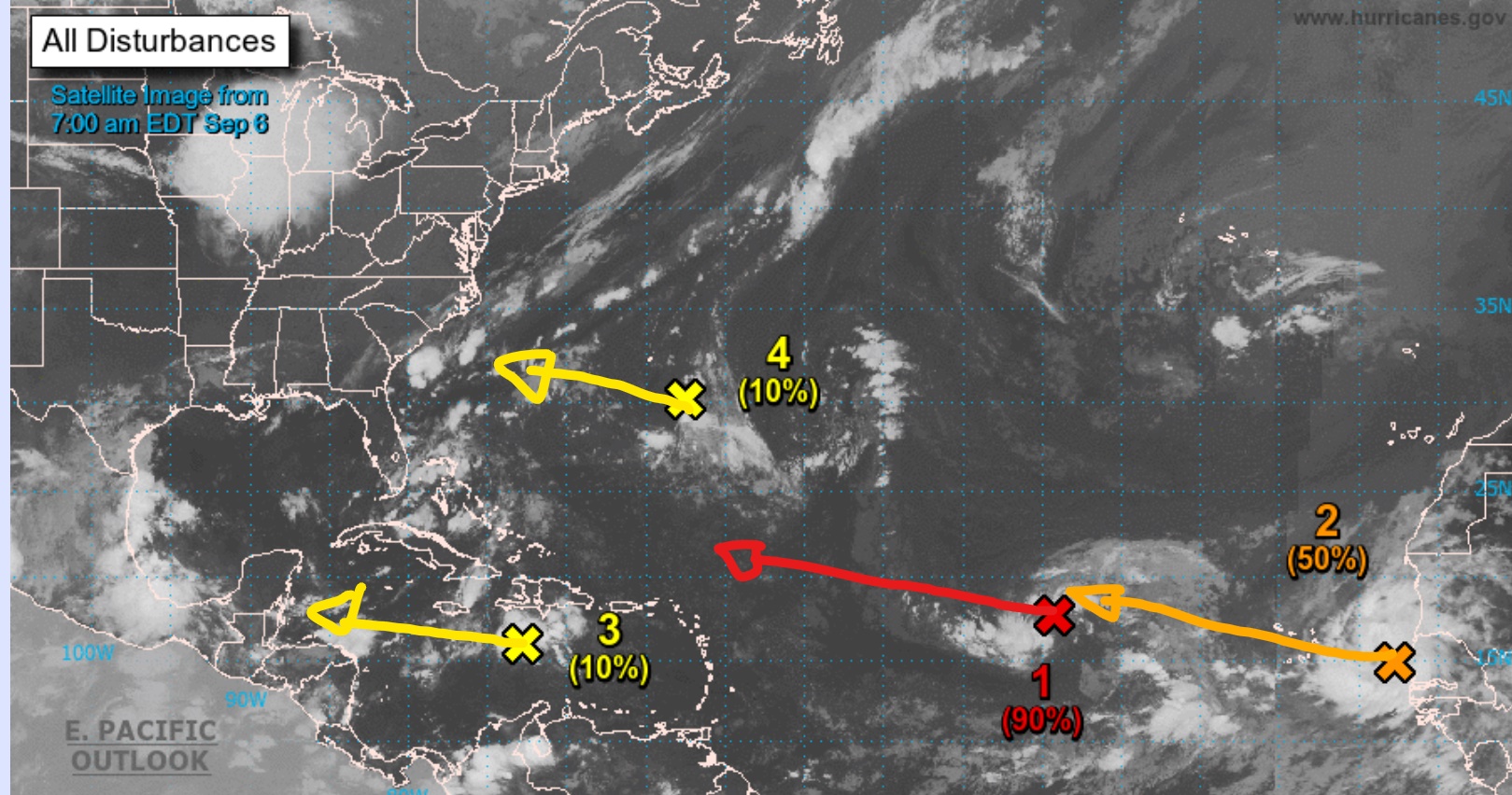
as nothing changed out there for us, no comments on the Graph necessary.
i guessby Tuesday I will start calculations of the Red cross.
Yellow 3 will most likely disappear by Tuesday, no development expected.
Yellow 4 is not in our area.
Brown 2 just hit Atlantic waters, so we wiat a few days to see whats out there.
long term tracking for Red and Brown does not bring the DR in the danger zone.
all fine so far for DR
Have a great sunday
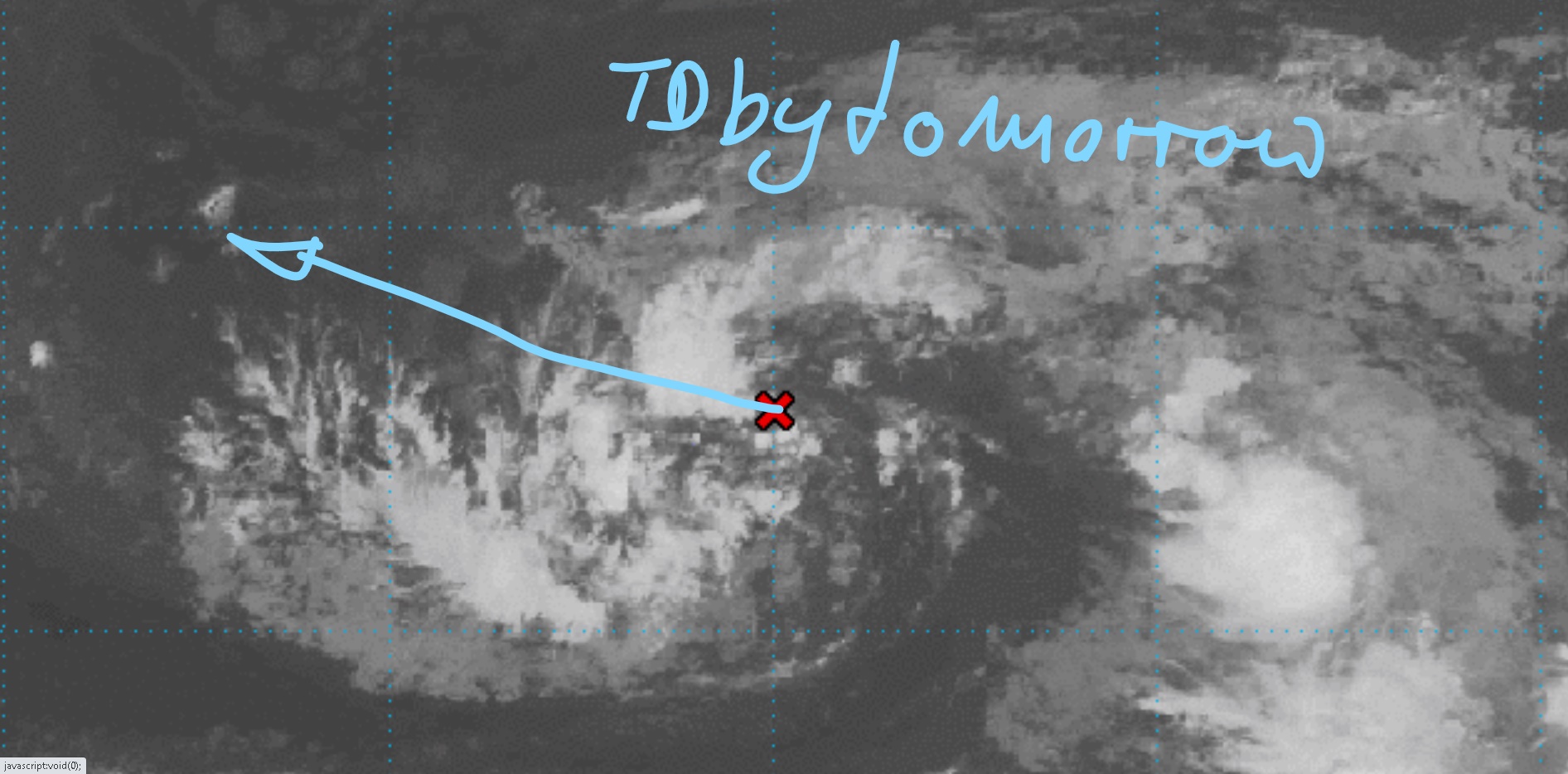
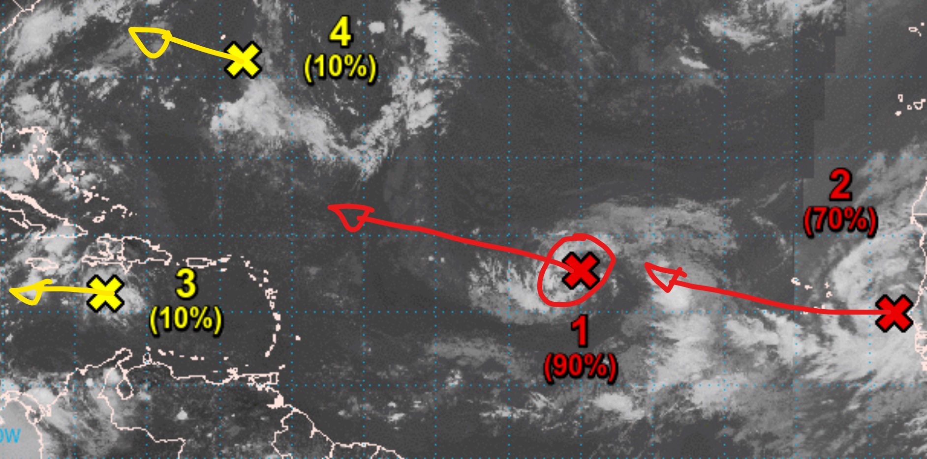
Red1, also shown in Blue in the first cose up shot, is getting better organized and should be a TD by tomorrow.
Red2 already comes quiet good organized with the beginner package, but is too new to tell. to be observed the next couple days.
Yellow3 will disappear from the maps soon.
Yellow4 is not in the nor on any way toward sthe Caribbean.
No system nor cloudy area between here and Africa is on any way to come near the DR at this moment.
so by now, what ever develops, maybe of interest to teh curious Fisherman, but not of concern for anybody else.
no real news tonight, as thing keep expected directions.
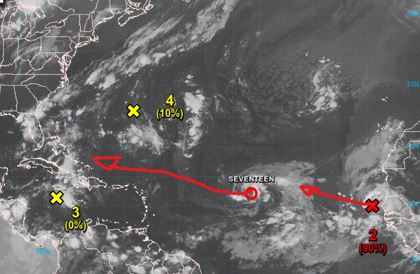
Yellow 3 is falling apart.
Former Red1 became tonight TD17, wandering mainly WNWwards to miss the Islands on their NE.
Red 2 is good organized and will be TD18 soon, duing today/Monday, no later than Tuesday.
None of the actual Systems is expected to come too close to DR, so no concerns about anyhing at this time.
One for the early bird fearful observers:
we have a real Low Pressure System wandering over Central Africa(yeah, almost 2 weeks aay from the Caribbean, lol).
it is a real strong 1003mb surface low, such usually makes a lot of noise when hitting hot tropical highway waters.
so our long rage scared ones have now something to watch for a week, before it may then hit the highway early next weekend.
Hey, I will not observe it before it is over water, so i leave that early observation stuff to others.
for the Highway between Arica and the Caribbean, we look all fine so far, with one eye permanently kept on TD17 and soon TD18, just in case one would do any unexpected turns or such. but the the outlook none willbecome any danger for DR.
for this time of year a perfect strat into the new week.
calm conditionsunder sunny skies here on the East
and the days ago expectations are exactly what we have running: Zero.
the Disturbance in the Caribbean Sea diminished.
the Disturbance SW ofBermuda drift towards the USA.
TD17 is now TS Paulette.
the disturbed weather between Africa and the Cape Verde Islands is TD18.
The Sum:
none of the clouds anywhere out there is on any way anywhere near the DR.
the hard Frontier of the Atlantic High is located far North at the moment,
so storm tracking tendency is strong NWwards, a open path for the hurricane graveyard.
as long as no surprising new one pop's up near the Island, so long we are good for a worry free week on da beach.
cheers
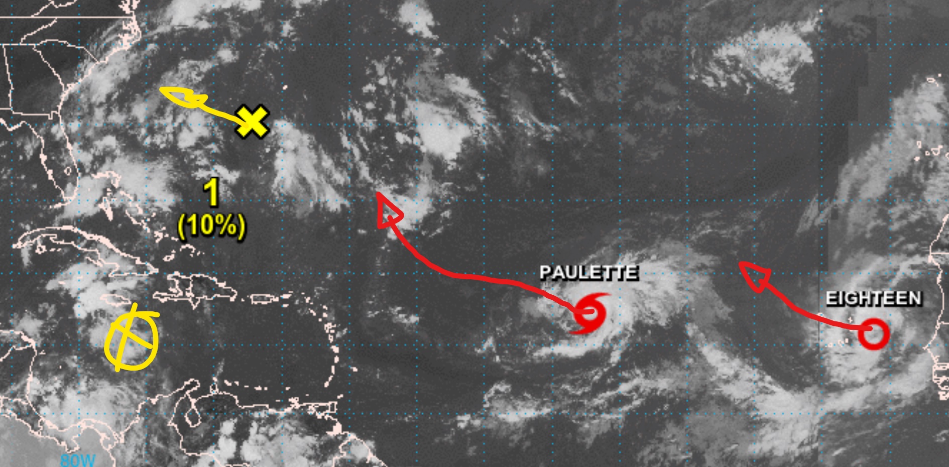
the negative result of this nice week will be that Paulette and follower will moisture our highway, thwy will not leave much if any dry saharan dry air layer left over the highway. the same way the last 2 disturbances in the caribben se moistured our near surroundings the last several days,
so the hot highway will have a fast racecar pavement.
but steering currents are blowing weak, hence you will see Paulette to be around for a week or more, moving very slow forward, it could even become stationary.
so the hot highway will have a fast racecar pavement.
but steering currents are blowing weak, hence you will see Paulette to be around for a week or more, moving very slow forward, it could even become stationary.
here some nice loops closed in on the actual storms on the highway.
first one is TS Paulette, well organized, small compact TS.
TS Force extends only a few miles out on it's NE, it is just a nice fresh wet breeze when you are 20 miles off the center of Paulette.
conditions indicate that it will barely move forward for a couple days and kepe it's powers, but I don't see much chances for significant strengthening.
number 2 is TD 18 approaching the Cabo Verde Islands.
still not full organized but on such early stage very well defined.
this one will be declared also a TS and get it's name very soon, most likely befor today is over.
Paulette:

 www.star.nesdis.noaa.gov
TD18:

 www.star.nesdis.noaa.gov
first one is TS Paulette, well organized, small compact TS.
TS Force extends only a few miles out on it's NE, it is just a nice fresh wet breeze when you are 20 miles off the center of Paulette.
conditions indicate that it will barely move forward for a couple days and kepe it's powers, but I don't see much chances for significant strengthening.
number 2 is TD 18 approaching the Cabo Verde Islands.
still not full organized but on such early stage very well defined.
this one will be declared also a TS and get it's name very soon, most likely befor today is over.
Paulette:

Post-tropical Cyclone Paulette at 34.8°N - 20.0°W - NOAA / NESDIS / STAR
Near real-time publication of GOES-East and GOES-West images from NOAA/NESDIS/STAR
TD18:

Post-tropical Cyclone Rene at 26.9°N - 49.3°W - NOAA / NESDIS / STAR
Near real-time publication of GOES-East and GOES-West images from NOAA/NESDIS/STAR
I hope they both continue to travel more north than west. Same for the trough expected to come off Africa in a few days. The middle of the Atlantic is a fine place for them as far as I am concerned.
nothing new from the stormy front today.
all is fine around our 'hood.
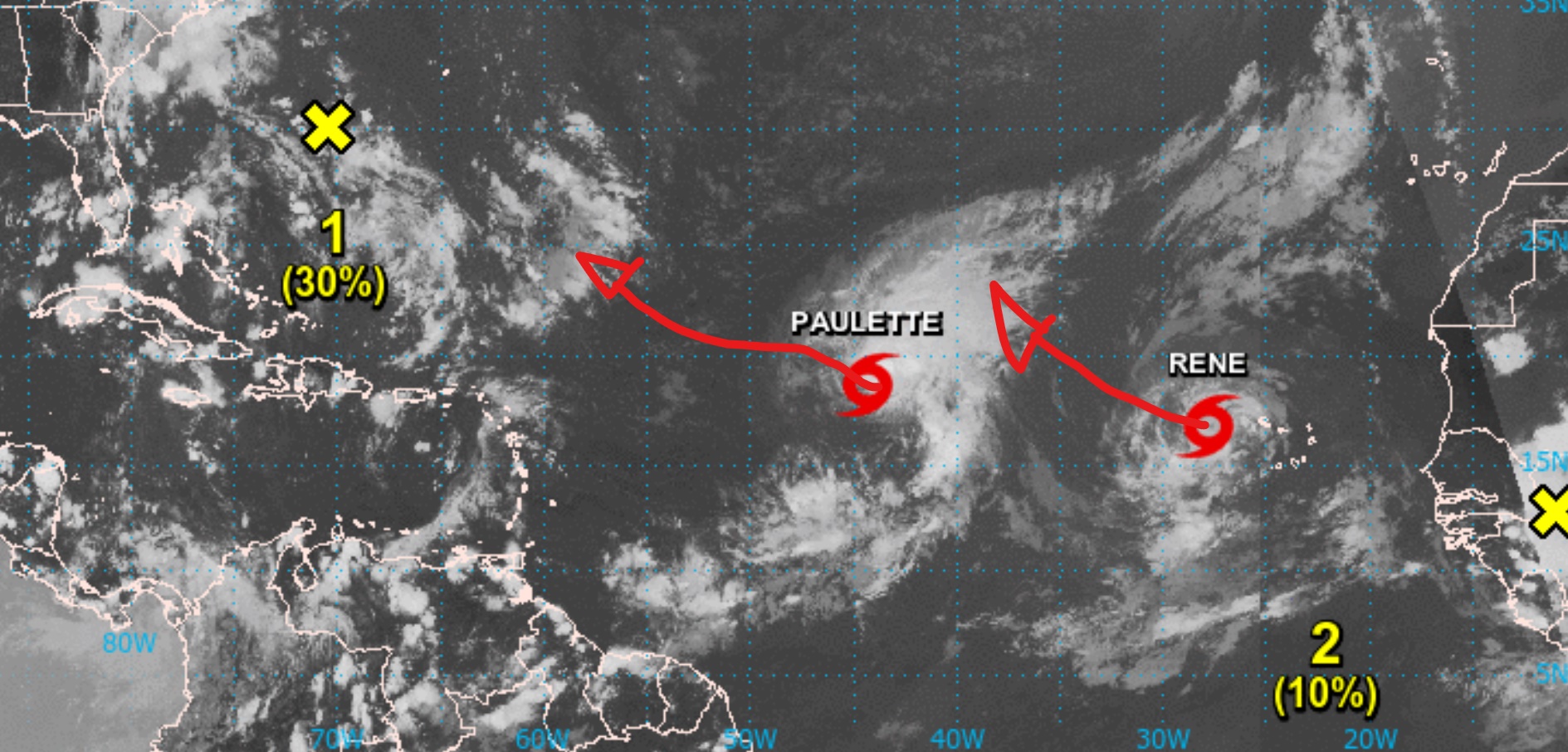
all is fine around our 'hood.
we are just at the beginning of the peaktime of our hurricane season.
the early season rarely show's a high amount of cyclonic energy.
the big boys and gals are almost always forming during the later part of the peak season, towar later septmber.
we had so far a above number of storms, weshould expect toalso get a numebr of Hurricanes including mayor hurricanes on the map
during the next 5 weeks.
i don't like the total amount of cyclonic energy as a measure not much, it does not means anything in case of dangers or damages.
for example this 2020 season so far we had a low cycl. energy accumulation,
BUT we already had 2 Tropical Storms(not even any hurricane involved) which combined did way more damage and harm to DR
than most years all TS and Hurricanes combined do.
and we are still at the beginning of the season.
today's look on the weather highway does not show any news, and thats good news.
none of the active systems/disturbed weather areas is on any way anywhere near our Island.
TS Rene is the one with a slight chance to reach the Hurricane Trophy, but not for much time, IF it reaches the windpowers and manage's to form a eyewall to be one.
steering currents will actually bring all the shown stuff NWwards, out on open mid Alantic, far away from our home.
even the still not existing one, a disturbance over west africa, to hit the highway tomorrow, will be caught by those steering currents and never come anywhere near us.
Keep enjoying beaches and cold drinks, all is fine
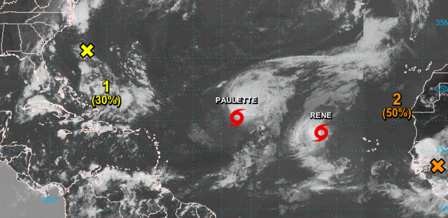
2 TS and 5 Systems to watch at once on the Map, quiet some action this young peak time of the season.
so far no danger to spot for our Island.
the "closest" to some "maybe danger" in our future could be the Wave which just hit Atlantic Waters Today,
it is on the graph the Red Cross on the far right side.
the many prior storms and systems over the higway cleared the pavement from dry air, so development is very likely.
as for a reliable Tracking Forecast we have to wait til late weekend/early next week,
to find out if this one could reach the Caribbean/near our soil.
for this week and coming weekend all looks fine for us.
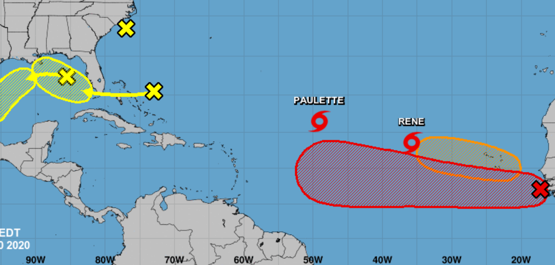
TS Paulette is a powerful storm and will hang around as a Hurricane for many days starting early weekend.
TS Rene in the wakeof Paulette is loosing powers and organization, it will not grow further.
the System SE of Cabo Verde still does not show a clear form or movement, it is too early to guess on.
TS Rene in the wakeof Paulette is loosing powers and organization, it will not grow further.
the System SE of Cabo Verde still does not show a clear form or movement, it is too early to guess on.
No guessing allowed Mike. Only detailed study of the steering patterns and then your best take on those results. 
- Status
- Not open for further replies.

