hurricane season 2017

Status
Not open for further replies.

jstarebel

Silver
Oct 4, 2013
3,330
333
83
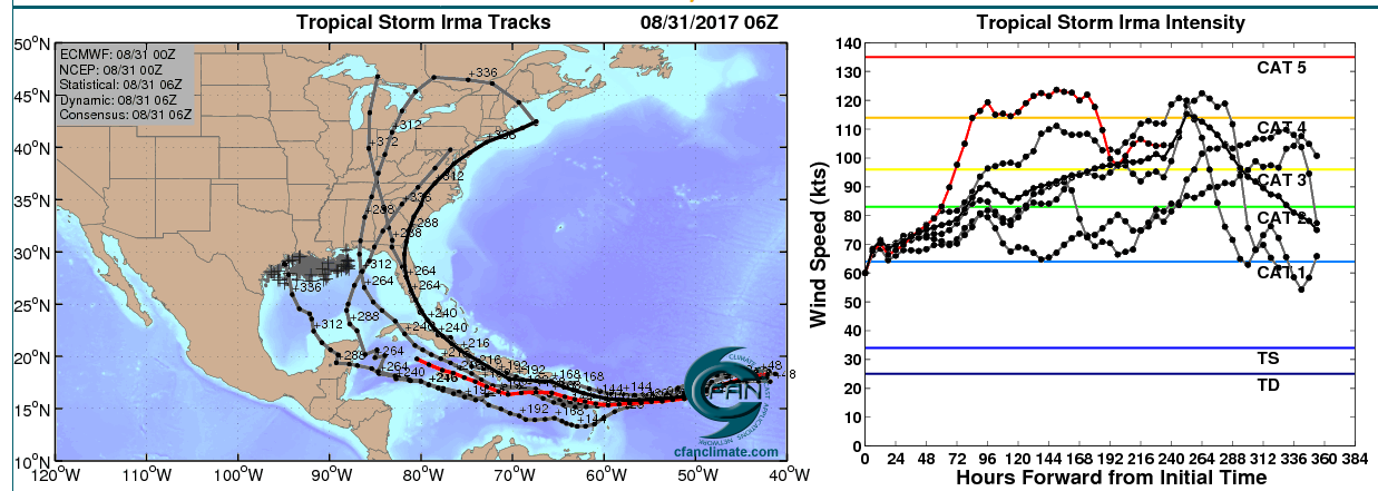
55.0W16.0N is my personal set deadline/latest point to start a Turn towards WNW to make it for a interesting action week but on the still safe side for Paradise.
at the moment, but that is of course a long range tracking outlook with all known uncertainties,
the Point of Turn calculated by NOAA is 52.2W/16.1N.
I like the NOAA calculation much more than my own set "last point of Hope",
as it would leave us on the safer side, further away/less blown over.
everything further East and/or further North, would bring it further away from us on a bypass NE of the Islands.
everything W and/or S of that Point would not be named Funny by anyone nor any means.
patience is the name of the game, patience.

Mike

Still too early to tell. How far south the high pressure pushes the system is the wildcard in all of this. I'm needing to make some hard decision as I sit in St.Maarten. What's funny is I have a doctor's appt. and am scheduled to fly to St.Thomas on Tuesday. The only way that's happening now is if I sail down. Can't chance not being able to get back or not having enough time to set out my gear if a move is necessary. I Also don't like the idea of setting out a major cane in SXM. STT Would be a better choice. Saturday is decision making day. Thanks for sharing your perspectives Mike. They help a lot.
 

MikeFisher

The Fisherman/Weather Mod
Feb 28, 2006
13,896
2,486
113
Punta Cana/DR
www.mikefisher.fun
the best and most accurate follow up on Irma you could do, is to keep an eye on the NOAA updates on:
(check the box: "Tracking Points")
http://www.ssd.noaa.gov/goes/east/catl/h5-loop-vis.html


here is a overlay of the Irma Sat View with some of the best reliable tracking models:

Irma 310817 5PM.jpg

for the next 2 days over all intensification may Trick us and only show 5-10mphr increses on the max windspeeds.
tis will be due eyewall replecement cycles.
Irma is a very big and powerful Storm with an actually supersmall Eye.
that small center was a perfect constructional feature for the fast intensification.
to hold the high powers and grow them up and over a wide Center Area, it needs a bigger eye, a much bigger eye.
the eyewall will be repleced several times during the next 2 days.
such replacements cost the storm power, but as it still will continue to rise the bar, the losses will not result and any measurable powerlosses, it will simply seem to stay on the same powers, while in reality it gains powers, losses some on replacement and quickly gains them back.
each replacement of the eyewall will result in a bigger eye.
each bigger eye will result in the Top Powers spread out over a much wider/larger area.
this weekend, after such constructional changes been completed,
Irma will have a monster wide center which spreads out Top Range Hurricane Force winds over a very large circle
and TS Force Winds to be received extremely far from the Center over a wide circle.
how wide we will not know before the contsuction is finished.

here you can see the actual small Eye,
this Floater should autoupdate itself and during the next couple days show us the bigger new Eyes:
vis-animated.gif


Mike
 

jstarebel

Silver
Oct 4, 2013
3,330
333
83
No doubt this storm is going to stay strong and I don't see any chance of it weakening either. Your point of it growing larger as the eye expands makes perfect sense which means the further West I can get, the better off I will be. Thanks for the links too!
 

MikeFisher

The Fisherman/Weather Mod
Feb 28, 2006
13,896
2,486
113
Punta Cana/DR
www.mikefisher.fun
Still too early to tell. How far south the high pressure pushes the system is the wildcard in all of this. I'm needing to make some hard decision as I sit in St.Maarten. What's funny is I have a doctor's appt. and am scheduled to fly to St.Thomas on Tuesday. The only way that's happening now is if I sail down. Can't chance not being able to get back or not having enough time to set out my gear if a move is necessary. I Also don't like the idea of setting out a major cane in SXM. STT Would be a better choice. Saturday is decision making day. Thanks for sharing your perspectives Mike. They help a lot.

you are sitting in a hot-zone, yep.
Irma is a perfectly well formed Storm.
round powerhouse Center spreading the powers out far from it to all sides.
then the outer powers:
heaviest far from Center powers, as usual with Storm out there and moving into dryer air towards WNW,
are loacted far from Center NE.
and also typical, less powerfull than the NE but still highest storm powers with loads of water,
on the far SW of the Center, which is the side that should be closest to or go over the Northern Islands,
IF acxtual Tracking stays on "Track".
no need to talk about any area to get the Center of Irma over Land,
where ever such would happen, there would be nothing left than a load of trash to carry away.

right now no Island is in jepardy for a straight walk over,
but right now the final tracking isn't decided, yet.
in case the Tracking shows a walk over inhabited areas
the only way to survive would be full evacuation of everybody, to not even leave "security" or such behind.
as we know such evacuations are impossible, for any inhabited coastline and/or Island anywhere.
that Irma better stays on Track or better move's it's Azz even further N than predicted.

the actual short of 28C Hot Sea Surface Temps will by the weekend be over 29C,
the closer to the caribbean the hotter.
where ever i search for some kinda brakes to put on those risining powers, nothing to be found tahn the opposite.
let's see how it looks for you on Saturday.
I agree, to be out of quick reach of your Vessel is not an option.

Mike
 

MikeFisher

The Fisherman/Weather Mod
Feb 28, 2006
13,896
2,486
113
Punta Cana/DR
www.mikefisher.fun
to it's W and NW Irmas is running into Hostile 30 and up to 40 knots windshear.
there is always hope for a knock, but i doubt to see significant effects on it.
the Storm looks smooth running, without struggles on anything, it has a powerful ROUND Circle Center,
it is a perfect Storm well fueled machine.
but it would be nice to see dry air reaching into the center during a replacement of the walls.

Mike
 

MikeFisher

The Fisherman/Weather Mod
Feb 28, 2006
13,896
2,486
113
Punta Cana/DR
www.mikefisher.fun
the ECMWF is the far most reliable Model for Tracking forecasts the last years.
it is still very widespread because for the different runs/spaghettis
different Time of Occurance and different powers of the Ridge to the North is entered as a parameter.
the Influence of the High and building up Ridge to the North of the Storm is the decider of it's Path.
the ECMWF Spaghettis will go into perfect agreement during the next couple days once the Ridge is up.
the GFS Tracking forecast would of course be our prefered one to come true,
but i doubt such early turn towards the WNW.
finally a middle lane between both Models will bring Irma on a only few hundred miles very close Pass to the NE of the Islands with it's southern powers blowing over the northern Islands.
later directions, from after reaching the NE of the Islands, are very uncertain and by now not even prognosted,
because by now it is not even agreed on that the Storm will go to/reach a position NE of the Islands.
aside of watching a movie tonight i will keep an eye on the floater,
hopefully watching that the Biach get's in trouble with the Dry Air that moved down on it's W and NW
to be injected into the core while the Wall is down before the new one is closed on a replacement.
I wanna see that.
this movie is shown on here and the Main Actor is the dry air masses shown in yellowish costumes,
while the main power of the game, named Mr Super Windshear, is not shown on the screen,
but acting all the time.

wv-animated.gif


Mike
 

MikeFisher

The Fisherman/Weather Mod
Feb 28, 2006
13,896
2,486
113
Punta Cana/DR
www.mikefisher.fun
at this moment Irma is running the former powerful nortehrn Band/Quadrant smooth on powers and dried out of moisture.
we have to wait til the morning to see if that's a power loss on taht side of the Storm or just a momentarily effect during work on the Eyewall, which always shows times of shutting down some power areas just to have them back some hours later as if nothing happened.

maybe good news on the Tracking Front,
but we keep in mind that we are still very far away to get reliable Tracking for the 2nd half of next week,
but on the newest model run updates from just 40 minutes ago/11PM,
the NHC TRacking Calculation (shown as the Red Dot Spaghetti) been corrected significantly further North than it was on the earlier pubished calculation.

storm_11


Mike
 

Natu

Member
Jan 20, 2013
283
8
18
I was seeing the european model in Windy.com and it shows the storm missing the islands to the north, but close enough to give us significant rainfall and cause landslides, floodings etc. Especially in the Cibao region.

Actually, according to that model, the north coast will probably get hurricane level winds.
 

2020

Well-known member
Apr 10, 2012
686
253
63
Las Terrenas

MikeFisher

The Fisherman/Weather Mod
Feb 28, 2006
13,896
2,486
113
Punta Cana/DR
www.mikefisher.fun
This does not look good.
Category 5 - per Euro model predicated to hit the DR within a few days. I'm puzzled why there is little coverage in local news over there.

We are in the process of switching property insurance companies so we'll probably get screwed. Lovely.

http://www.foxnews.com/world/2017/08/31/irma-rapidly-strengthens-to-category-2-hurricane-forecast-to-be-extremely-dangerous.html

thats completely Crap, BS, that's why our Serious News does not bring any coverage of such Fox News sh.it.
how could a Storm pass such far distancejust in a few days??
how could fidiots on TV know anything about the tracking and powers of such Storm??
follow the advisories of the NHC and do not listen to any TV Clown,
those guys have those Jobs because they are to stu to drive the Dumpster Truck.

Mike
 
Status
Not open for further replies.