Work begins to widen kilometer 9 of Duarte Highway from 8 to 14 lanes

Dolores

Administrator
Staff member
Feb 20, 2019
15,480
2,415
93
Screen-Shot-2022-05-18-at-7.52.51-AM-1024x640.png


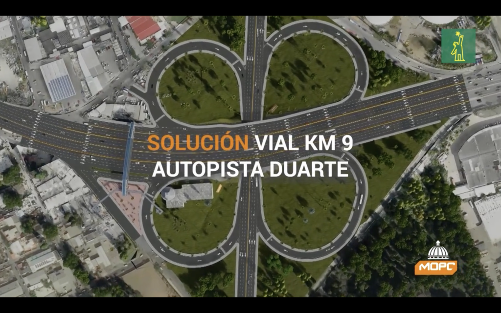
The Ministry of Public Works has begun the works to improve road connections at kilometer 9 of Duarte Highway. Once completed, at that point the main highway linking north and south of the country will have 14 lanes, up from eight at present. The works have a cost of RD$900 million and are scheduled to be completed in 10 months, or by February 2023.

The roadworks include a bridge that will be built on the north side and another on the south, parallel to the existing ones, with lengths of 30 meters and widths of seven meters. The old structures will be reconstructed. A pedestrian bridge, drainage works, sidewalks, curbs, tree planting, lighting, and urban restoration are also part of the project. Street vendors will be relocated.

The reconstruction of the central bridges will allow General Gregorio Luperón Avenue to be widened from 4 to 6 lanes, increasing the...

Continue reading...
 
Last edited:
  • Like
Reactions: bachata

JD Jones

Moderator:North Coast,Santo Domingo,SW Coast,Covid
Jan 7, 2016
11,698
8,129
113
Praise the Lord!!!! Next bottleneck after this one - Pinturas.
 

NALs

Economist by Profession
Jan 20, 2003
13,370
3,150
113
Yes that off ramp from 6 de Noviembre!
They are suppose to build an overpass on the intersection near there with Isabel Aguiar. Then a tunnel goes under the Plaza de la Bandera giving 27 de Febrero and the Prolongación a direct straight connection. Flow of traffic will be non-stop with no need to stop at the lights if you aren't turning into Luperon or Isabel Aguiar. The thing is this has been in the plans for years. When I first saw the renders for these improvements Leonel was president.
 
  • Like
Reactions: JD Jones

JD Jones

Moderator:North Coast,Santo Domingo,SW Coast,Covid
Jan 7, 2016
11,698
8,129
113
Truth be told, as great as that would be for the bottleneck at Isabela Aguiar, all it would do is move the bottleneck down the road for a half a klik or so; the entire Prolongacion 27 de feb is a traffic jam in itself.

The jam at Isabela Aguiar helps controls the feed into the prolongacion. This I know from 20 years of driving and living in that area, and why I eventually moved to San Cristobal.
 

El Hijo de Manolo

It's outrageous, egregious, preposterous!
Dec 10, 2021
3,937
2,586
113
Dominican Republic
They are suppose to build an overpass on the intersection near there with Isabel Aguiar. Then a tunnel goes under the Plaza de la Bandera giving 27 de Febrero and the Prolongación a direct straight connection. Flow of traffic will be non-stop with no need to stop at the lights if you aren't turning into Luperon or Isabel Aguiar. The thing is this has been in the plans for years. When I first saw the renders for these improvements Leonel was president.
96 or 2004 to 8 lol wait edit 2012
 

NALs

Economist by Profession
Jan 20, 2003
13,370
3,150
113
96 or 2004 to 8 lol wait edit 2012
Oh, it gets better. You this this image below?

96281825-4A22-4D1D-B94A-8C8BA8B57FF9.jpeg


This was the plan for the current Santiago - Puerto Plata highway that passes through the tunnel. When was it published you ask? In the Listín Diario in 1965, four years after Trujillo was killed and there hardly were any cars in the DR, where tapones was unheard of, tourism hardly existed (no Playa Dorada, no Punta Cana, no Juan Dolio, no Cabarete, Puerto Plata was the center of town and that's it with no malecón and places like Torre Alta and Bayardo, Cofresí, Costambar were lots of trees with no roads, buildings, nothing; no foreigners visited Sosúa which was a small village enough to miss if you blinked while passing through, etc), when Santiago was the historic center and the monument was outside town in the countryside, when Santo Domingo was the biggest city with some 200,000 people. Let that sink in.

Now is 2022 and it still doesn't look like that.
 
Last edited:

El Hijo de Manolo

It's outrageous, egregious, preposterous!
Dec 10, 2021
3,937
2,586
113
Dominican Republic
Oh, it gets better. You this this image below?

View attachment 5667

This was the plan for the current Santiago - Puerto Plata highway that passes through the tunnel. When was it published you ask? In the Listín Diario in 1965, four years after Trujillo was killed and there hardly were any cars in the DR, where tapones was unheard of, tourism hardly exidted (no Playa Dorada, no Punta Cana, no Juan Dolio, no foreigners visited Sosúa which was a small village enough to miss if you blinked while passing through, etc), when Santo Domingo was the biggest city with some 200,000 people. Let that sink in.

Now is 2022 and it still doesn't look like that.
Look at that wagon. It looks like the Griswold's!
 

JD Jones

Moderator:North Coast,Santo Domingo,SW Coast,Covid
Jan 7, 2016
11,698
8,129
113
I remember traveling from Santiago to Santo Domingo in the 70's.

Once you left the monument, it was a two lane road through the campo all the way. What a difference.