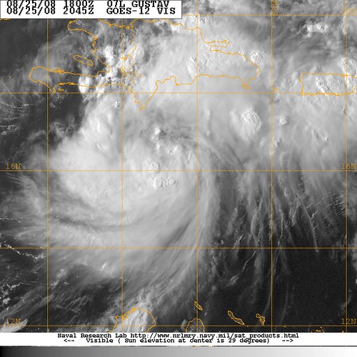
Hurricane Gustav .. was Tropical Storm Gustav

laurajane

Bronze
May 23, 2005
1,230
214
63
www.thecircusofdreams.com
A little concerned!!

I am in Higuey and all though i realize it is unlikely this area will experience the full force of a hurricane, I am aware we will experience lots of rain. My house has flooded twice in the last couple of months including last weekend with tropical storm faye.

My husband, annoyingly laid back has just left for work in Punta Cana, Is it due to hit in next 12 hours? Unfortunatly my internet has become extremley unreliable today so keeping up to date has been difficult.

Maybe Mike and Chris in Punta cana can help give me some idea of what i maybe expecting and when? Thanks for those of you who are keeping all of us updated.

Laura :)
 

Matilda

RIP Lindsay
Sep 13, 2006
5,485
338
63
pouring with rain in Juan Dolio since lunchtime. Little wind. It will get closest to Santo Domingo at 11.30 tonight so I understand and the closest point will be 158 miles away. Thats the latest info. So hopefully not too much wind but methinks plenty of rain to come. Don't panic LauraJane, your roof probably won't blow off but I would get your buckets ready!!!

Matilda
 

laurajane

Bronze
May 23, 2005
1,230
214
63
www.thecircusofdreams.com
pouring with rain in Juan Dolio since lunchtime. Little wind. It will get closest to Santo Domingo at 11.30 tonight so I understand and the closest point will be 158 miles away. Thats the latest info. So hopefully not too much wind but methinks plenty of rain to come. Don't panic LauraJane, your roof probably won't blow off but I would get your buckets ready!!!

Matilda

Thanks Honey! I hope you will be ok, Don't know what i can do but if you need me just call (if you can)!

:)
 

MikeFisher

The Fisherman/Weather Mod
Feb 28, 2006
13,771
2,206
113
Punta Cana/DR
www.mikefisher.fun
Laura Jane,
no danger for Higuey as long as people do not try to drive their jeepetas throu arroyos full of water like we sorrily saw during Fay.
Lambada,
absolutely agre on your one on the prior page,
if i get prepared for something bad and i can 'smile' afterwards about 'that been just some rain', i would be happy to show that smile, the opposite would be fatal.
and the important point you mentioned is the "don't get fooled when a alert get's taken back from hurricane warning to "just" tropical storm warning on less forward moving speed, because that is exactly where the danger increases, slower forward movement means more time of heavy rains, during storm hits people rarely die due to high wind speeds, but a lot die due to water forces(floodings and moodslides).

Dolores.
i did not get the point with Samana,
maybe i did misinterpret some prior post pointed towards Samana as one to St Dgo.
did not mean to mislead a thing.
take care all
Mike
 

CFA123

Silver
May 29, 2004
3,512
413
83
Little tropical wave 94L sure is growing up fast.
Thank goodness this puppy is for the most part south of the island.
I still feel for those along the south coast for whom it appears will feel the greatest effects. Let's hope it's bark is worse than it's bite.

2797187977_2f04b14bff.jpg
 

laurajane

Bronze
May 23, 2005
1,230
214
63
www.thecircusofdreams.com
Thanks for the advice, unfortunatly my house is on a main road and the road is slightly higher than the house so the water just pours in. I agree that taking the right precautions isn't dramatic as those who do will avoid a major headache during and afterwards should it turn nasty. It is very calm here at the moment after a hour of torrential rain, not so much as a slight breeze, which makes me nervous as we all know the old saying ha ha.

I hope all those on the south coast are prepared and that everyone gets through it with no more than a little inconvenience. Am hoping my husband and employees get home safely on their journey back to Higuey in early hours of the morning, I certainly won't be able to relax until i hear that usually annoying reverse horn tonight.

:)
 

Matilda

RIP Lindsay
Sep 13, 2006
5,485
338
63
Frighteningly calm in Juan Dolio now. No breeze, no rain and very still. Next update due at 8pm. Candles all at the ready for when the electric goes!!!!
 

Chris

Gold
Oct 21, 2002
7,951
28
0
www.caribbetech.com
These are best estimates and they may be out by 50 miles or 3 hours. The storm may stall out as we've seen with previous storms.

Currently the center of the storm is south/south east of Isla Beata about 75 miles off shore. Winds that you all can feel should be in the region of 20 to 30 miles an hour, so tropical storm force. This will get stronger.

In about 5 hours, the center of the storm will be about 30 miles south west of Isla Beata moving at 15 miles an hour to the north west with winds up to 60 miles per hour.

Although this is a tropical storm as yet and not a hurricane, and will pass the DR and not make landfall as it looks like presently, there is a lot of water in the system. There was an earlier post on rainfall numbers and Ill go check the expected numbers and post in a short while. We all know the risks of tropical rain in the DR. Floods, rivers bursting their banks, flash floods, mudslides.

Behind and around the center of the storm we will also have massive amounts of rainfall.

As Gustav moves past the DR and reaches the south coast of Haiti during the day tomorrow, it will almost certainly reach hurricane force. Get ready for a massive amount of water in the DR.
 
Last edited:

Dolores1

DR1
May 3, 2000
8,215
37
48
www.
Chris, do you forecast it will mean downpours of rain for the entire island, including Samana and Punta Cana, despite it being far in the Southwest on its way to Haiti.
Only a drizzle of rain in Santo Domingo after two downpours.
 

Chirimoya

Well-known member
Dec 9, 2002
17,850
982
113
It is quiet here in Punta Cana, after an overcast day with only a couple of brief moderate downpours.
 

jalencastro

Bronze
Dec 15, 2004
1,938
104
63
www.myspace.com
my concern is leaving tomorrow early morning to go to Samana....via the new highway, i dont know if driving is safe....i guess no sightseeing unless it is miraculously clear in the northeast [Samana] and the north coast [Cabarete and Puerto Plata]
so much for beaches..... :(
the city of Santo Domingo is a bit windy at the moment but eerily clm
 

whirleybird

Silver
Feb 27, 2006
3,264
322
83
my concern is leaving tomorrow early morning to go to Samana....via the new highway, i dont know if driving is safe....i guess no sightseeing unless it is miraculously clear in the northeast [Samana] and the north coast [Cabarete and Puerto Plata]
so much for beaches..... :(
the city of Santo Domingo is a bit windy at the moment but eerily clm

I am sure someone will correct me if I am wrong but I believe you should be fine leaving SD tomorrow to visit Samana via the new highway which is very user-friendly and quiet in comparison to any other route we have used in the past. North coast, i.e. Cabarete and Puerto Plata will probably just get light rain and a little thunder as it is now I think.
 
  • Like
Reactions: laurajane

Chris

Gold
Oct 21, 2002
7,951
28
0
www.caribbetech.com
Chris, do you forecast it will mean downpours of rain for the entire island, including Samana and Punta Cana, despite it being far in the Southwest on its way to Haiti.
Only a drizzle of rain in Santo Domingo after two downpours.

Samana and Punta Cana could have an outlying band of clouds hiding a tropical rainstorm or two, but the longer time goes on, the less the chances of real stormy weather in those two places. The storm is not very big as these things go and these satellite pics should give a good idea of where the rain is. At the moment we're seeing the North Coast getting quite a bit judging by the pink spots.

<img src="http://www.ssd.noaa.gov/goes/flt/t1/wv-l.jpg">

vis-l.jpg
 
  • Like
Reactions: AnnaC

Chris

Gold
Oct 21, 2002
7,951
28
0
www.caribbetech.com
I am sure someone will correct me if I am wrong but I believe you should be fine leaving SD tomorrow to visit Samana via the new highway which is very user-friendly and quiet in comparison to any other route we have used in the past. North coast, i.e. Cabarete and Puerto Plata will probably just get light rain and a little thunder as it is now I think.

That is quite correct for tomorrow whirleybird but you may be getting a little more rain in your neck of the woods tonight. Enough to cause floods by my reckoning.
 

jalencastro

Bronze
Dec 15, 2004
1,938
104
63
www.myspace.com
wow great info guys! everyone great help! im just concerned...i will keep my eyes open, watch the news, read dr1 and see whats up. im dissapointed with rain and trying to visit parks and or beaches with rain....fingers crossed
time to go out and eat some pica pollo and drink some rum! :)
 

Chris

Gold
Oct 21, 2002
7,951
28
0
www.caribbetech.com
The 8pm advisories suggest that Gustav will slow down a little during the next 24 hours. It was this pattern that caused such devastation over the DR last year and I do not enjoy seeing this. The rest of the 8pm advisory remains the same, mostly information that we've already discussed.

Just to reiterate ...
Gustav is moving toward the Northwest near 12 miles per hour or 19 kilometers per hour. The expectation is that the storm will slow down over the next 24 hours.

Gustav is now a tropical storm but is expected to strengthen into a hurricane over the next 24 hours.

(I notice that the NHC is leaving themselves a whole lot of leeway this season with predictive windows of 24 hours. I think this is wise.)

Tropical storm force winds extend outwards for about 50 miles or 85 kilometers or an hour's drive from the center of the storm.

The forecast track remains the same and the center will move near or over Haiti on Tuesday (probably during the early morning hours) and will hit Category 1 hurricane status around the time that it makes landfall.

If you find yourself on or near the South West coast of the Dominican Republic, you need to be prepared for a hurricane in the next 24 hours.
 

Texas Bill

Silver
Feb 11, 2003
2,174
26
0
97
www.texasbill.com
All should bear in mind that the most severe portions of a tropical storm/hurricane occurs in the North East Quadrant of the system. That means that the DR and Central Haiti will receive the most rainfall. The Central Cordellera should attenuate that somewhat, but be prepared for flash-floods and rapidly rising water in the lower levels as the heavy rainfall rushes down the mountains.
Just an added warning to what has already been published by the experts.

Texas Bill
 
Last edited:

Matilda

RIP Lindsay
Sep 13, 2006
5,485
338
63
Still very calm in Juan Dolio. No wind, no rain. The cicadas are still singing which is a good sign. It's when they stop that you need to worry!!!!

Matilda
 
  • Like
Reactions: laurajane