windy.com is anotherWeather.com is a good app for local weather - hourly and daily forecasts, weather radar, air quality, a lot of useful info. I tracked Isaias with it. Maybe there are better ones(?).
- Thread starter Olly
- Start date
You are using an out of date browser. It may not display this or other websites correctly.
You should upgrade or use an alternative browser.
You should upgrade or use an alternative browser.
2020 Hurricane Season
- Status
- Not open for further replies.
Glad your Back Mike and now with all the nice graphs, great.so here we go for today's afternoon outlook.
TS Isaias I do not watch that closely, as not anywhere near us anymore,
but it has not the super wide range of rainpowers it had while passing PR and DR.
it is wnadering NNW and should turn N then NNE, near the FL and SE US coastlines.
the powers left in Isaias are on it's Eastern parts, away from Land.
TD10 disappeared as awaited.
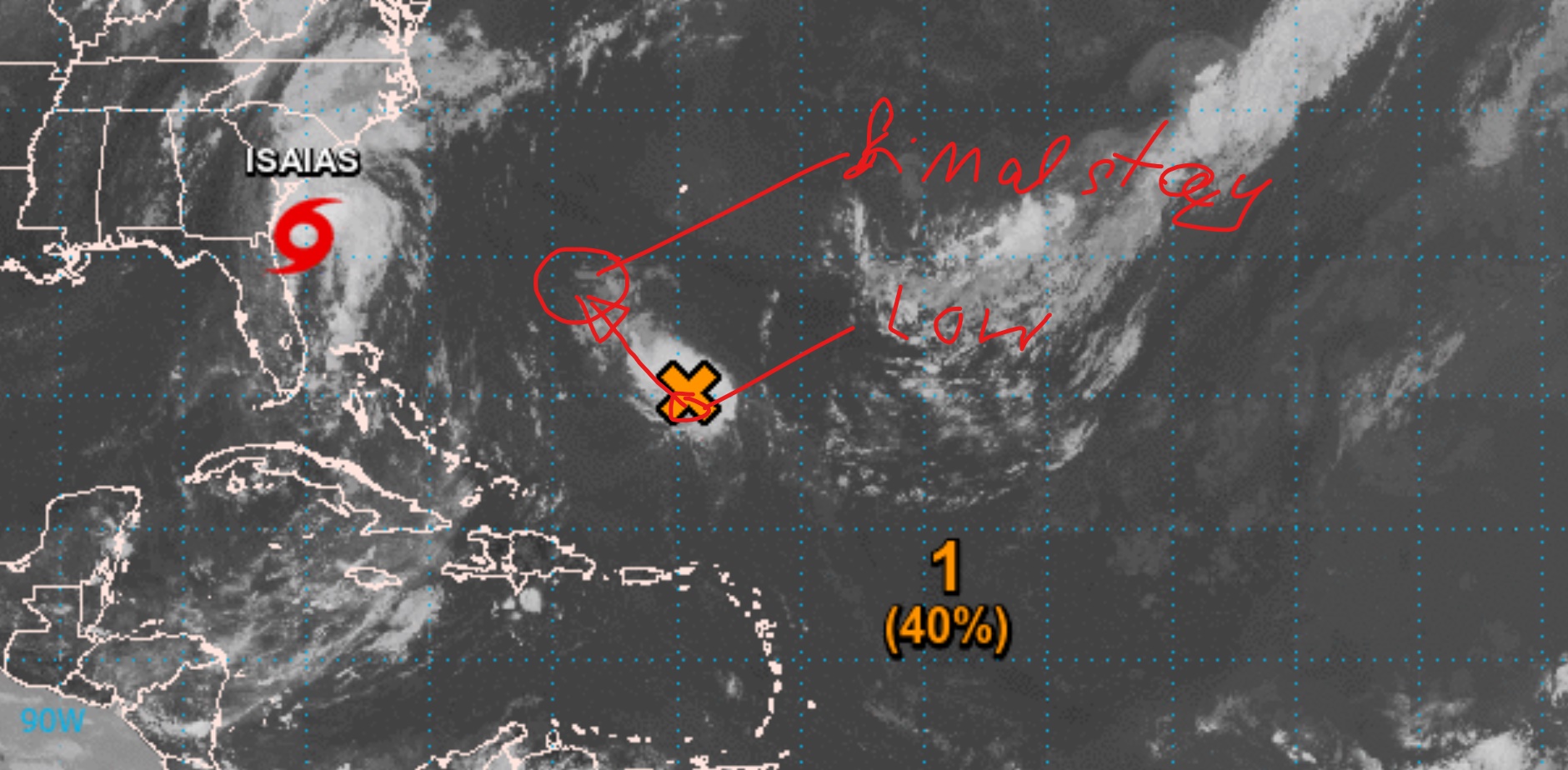
the only active System "near" our soil is the Invest off the Leeward Islands.
on the 2PM AST Shot it was located a bit less than 200 miles NE of the Leewards.
moving NEwards it should not come any closer to Land while arond the Leewards, PR or Hispañola,
so it is nothing really near for us.
View attachment 3053
here we see that the environment on it's path is free of dry Saharan Air, thanks to the pass of Isaias,
so this otherwise weak System has good conditions ahead to from a small Storm with the moisture it's Tropical Wave carries around.
chances are big to form TD11, but not today nor tomorrow, more likely Tuesday or Wednesday, when it is already North of the Islands.
View attachment 3055
the strongest rain areas and almost all Thunderstorm areas are located north of the Surface Low.
if this stays that way we will not feel nothing at all.
it's movement goes NW and should mid week point more to NNWwards,
not coming close to PR, DR nor the Bahamas.
once a Storm/TD formed, most powers should be located on it's North, away from the Greater Antilles/us.
View attachment 3056
so far nothing bad in vicinity between Africa and the Caribbean.
Xtraveller
It's the words "nothing will affect our island" that I like hearing the most.
the Surface Low is now located half way between the Virgin Islands and Bermuda.
it is moving quickly NW today and part of tomorrow.
it then has the strong influences of Isaias on it's NW and the Atlantic High on it's NE,
which will trap it between Bermuda and the Bahamas, where very likely will be it's final destination.
it could or could not become TD11 on wednesday/thursday, doesn't matter to us,
as it will not have the slightest influennce on our DR weather.
what still has influence on DR weather today and tomorrow is Isaias due the ver far form Center southern left overs.
right now it finished a few minutes lasting hard rainfall with nice windgusts here at my place, the 3rd of today so far.
so far on the East of DR it is just small scattered out cells, a couple miles down the road people may have gotten not a single drop of water today.
other than that, here we have a sunny and windfree day so far.
other parts of DR will still get some rain, which can become "significant"for already flooded areas, specially in the mountains,
so if you live in such area you should be ready for some more for a couple days.
those far out bands come in today from SW to NE and tomorrow more from S to N over DR, as Isaias moves NNEwards.
those rains will be more over easter Cuba and Haiti and Western DR, later today also for teh DR's mid East around Hato Mayor,
much less to nothing on the East around Punta Cana.
nothing of new danger out there for us for a few days.
we still get Wave after Wave rolling from Western Africa on the Tropical Atlantic,
but at the moment one show's to be strong in action with a Low, we still have almost a week to watch and get ready.
Last edited:
cavok, I have been using windy.com as well along with the NHC.
Welcome back Mike Fisher to the no off-topic version of DR1.
Welcome back Mike Fisher to the no off-topic version of DR1.
nothing bad out there for us.
we look good for a week ahead, which is the absolute max to look ahead of time.
the Low is now lingering SW of Bermuda, far out straight N of the DR.
it is barely moving and should drift slowly WSWwards for a few days, towards the North or Central Bahamas.
chances to become a storm are slim to nothing.
the actually 3 active Tropical Waves on our Hiighway are not associated with any significant Surface Low,
so they are normal Tropical Waves carrying moisture from E to W.
the next one to be. spotted by Satellite, is still over the W African continent.
while it shows to contain heavy weather, the nearest Surface Low is behind and north of the Wave, which makes interaction for the next days unlikely.
it should hit tropical waters late tomorrow or friday, so by then we will see who interacts with what.
looks like we have dry hot days ahead of us
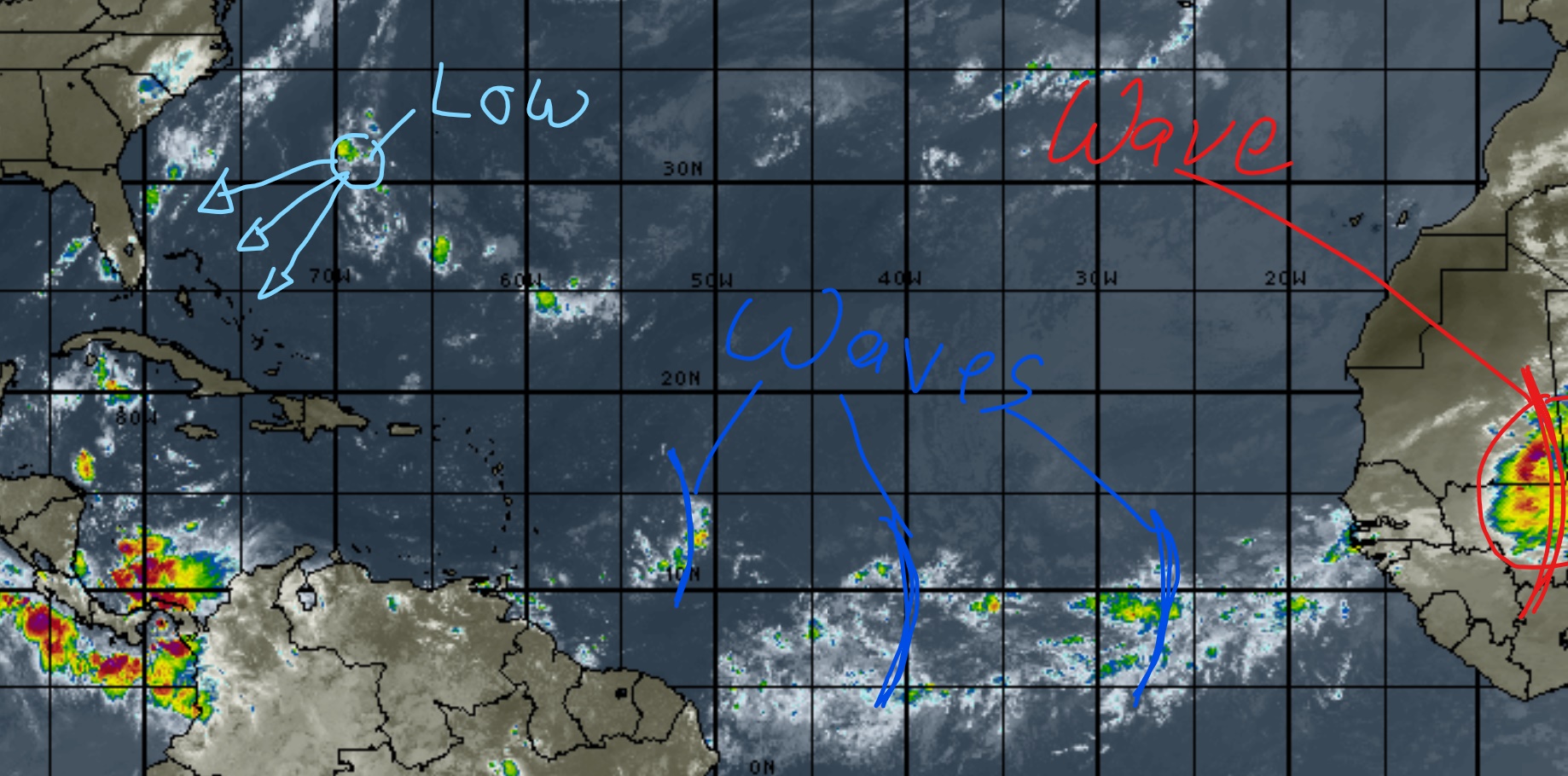
your photo is a bit out dated, from June 24th 2020.
at that time we had no significant Saharan dust over us.
right now we have, here is todays Sat Shot
Wow. What I was wondering was if that much dust has an impact on development of storms in that part of the Atlantic.
Yes,
If the atmosphere is dense of dry saharan air it minders the possibilities of storms to form/ intensify
Yes, it has.Wow. What I was wondering was if that much dust has an impact on development of storms in that part of the Atlantic.
If the atmosphere is dense of dry saharan air it minders the possibilities of storms to form/ intensify
Yes. That is a much better source of data. I had saved one but can't find it now.
if interested in such, save this one.
it is updated several times per day and also allows to see a forecast of the movement/development of the dry air mass/SAL(Saharan Air Layer).
if interested in such, save this one.
it is updated several times per day and also allows to see a forecast of the movement/development of the dry air mass/SAL(Saharan Air Layer).
Thanks. I will do that.
sorry, but a 8 minutes audio to listen to on a storm free evening is a bit too long for me, lol.
nothing to report about anywhere out there.
we have a tropical wave south of the Mon Passage moving westward, which carries some water.
some clouds and maybe some minor rain along the south and maybe even some clouds or drops for the East this evening and tonight.
the Wave almost mid Highway show's a weak low surface pressure, NOAA marked it as a Invest, but there's so far nothing in that one
and on it's way further West towards the Antilles, conditions will not be in favor for any storm for the next days.
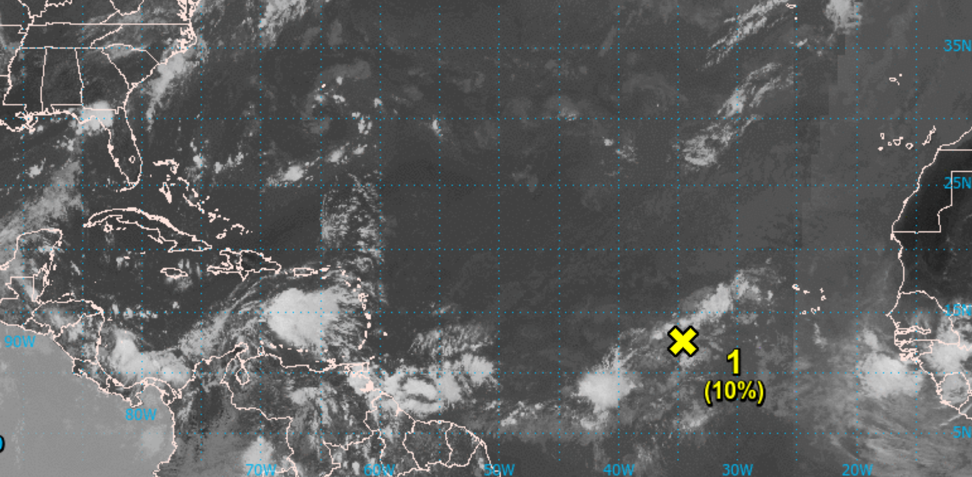
Weekend Up Date, without news to report.
the system mid highway, marked as Invest by the NHC, dissipated.
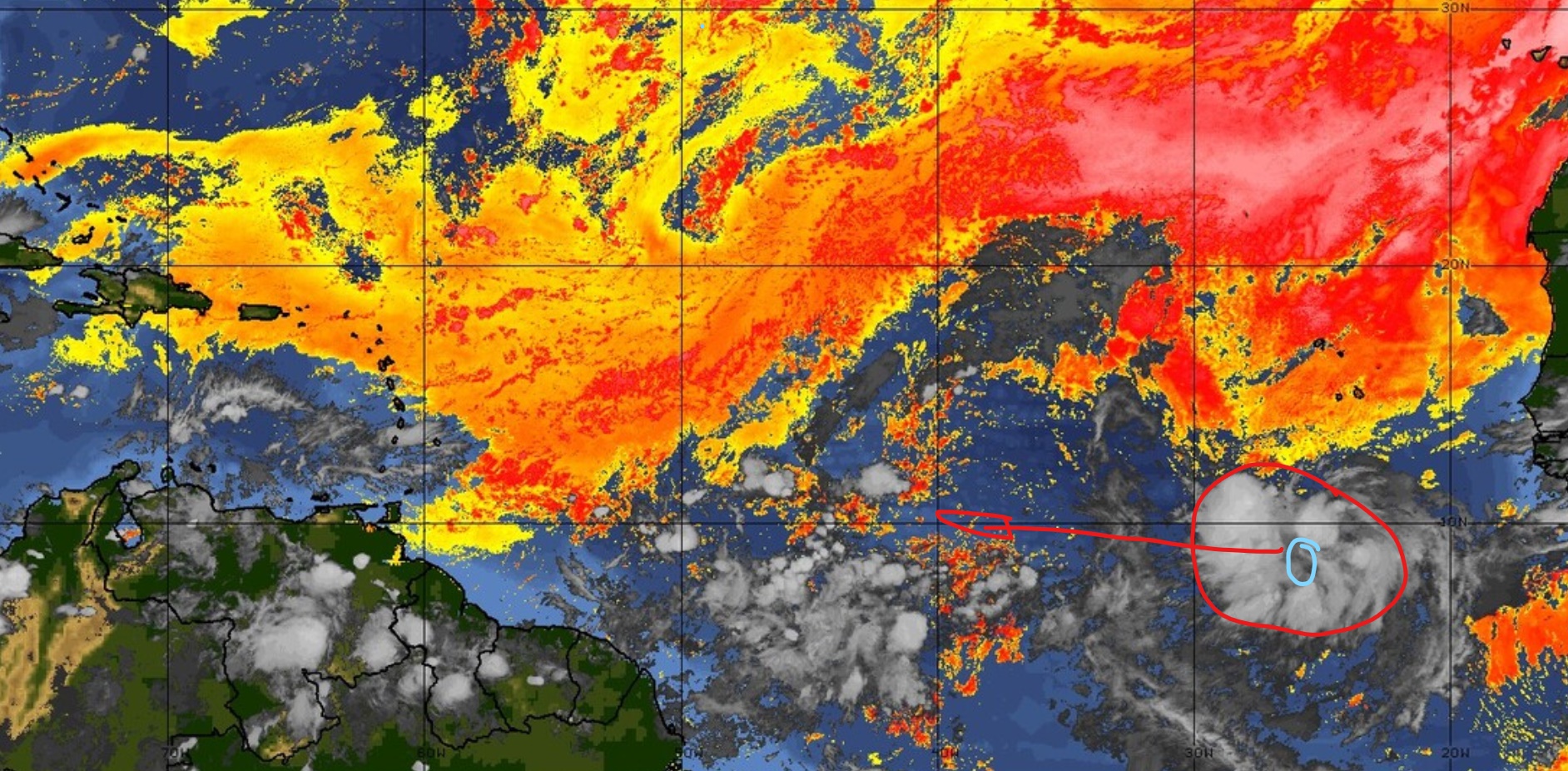
the new wave on the highway, now located SW of the Cape Verde Islands, is carrying a Surface Low collecting a wide area of moisture.
Thunderstorm activity so far is very low in it.
theoretically there would be some chances to develop the next couple days,
but I don't see such wide and at the same time weak system to become a storm that quick.
after half way on the highway, reaching 45W, conditions will not be in favor to develop something big.
all looks good for days to come.
Thx Mike. I hope your predictions turn out to be accurate. The last thing we need now is another storm. I hope this one and the rest to come just dissipate as well.
we sure will see a good number of further storms forming up this season.
chances are high that the alphabet with set names will not suffice and needs to be extended.
we are very early in the season and already saw a number, with Isaias we already had a early devastating one for part of DR.
the hottest phase of the season will start around Sept 10th, still 4 weeks to get conditions favorable.
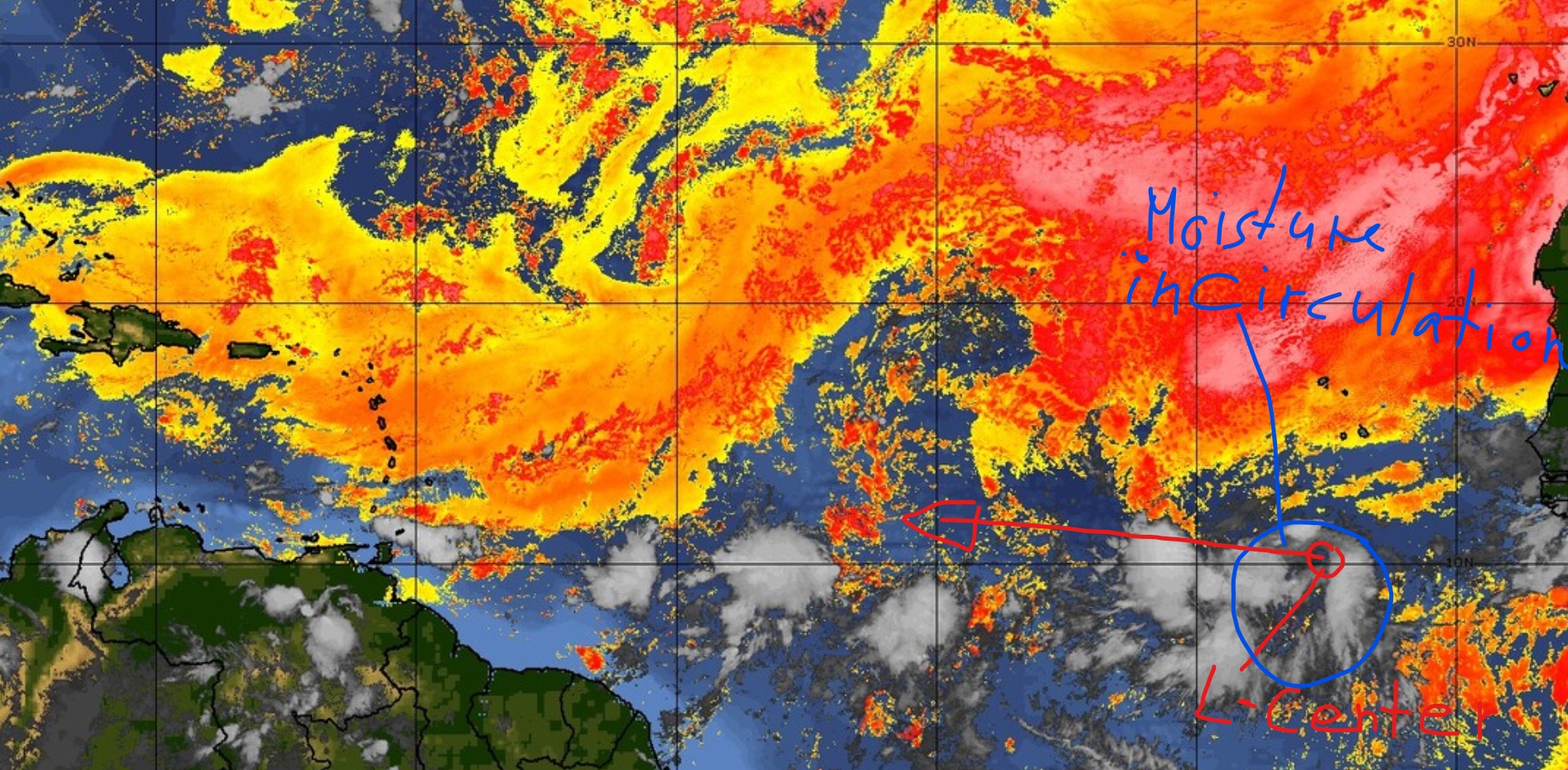
comparing my shot from last night, which was taken at 11PM,
with this one today, taken 8AM this morning,
we see that this low now show's a clear center position and moves a good defined circulation.
the last night huge area is cut down to the important basics:
smaller but good amount of moisture,
located on the 10thN, which allows the necessary spin,
15mphr forward speed Westward(10-15mphr is the ideal for improvements on the way.
this system has only 2 days to get formation and fueling together, as by mid highway it should start to run into dryer air on it's N and a good windshear going against it's circulation on it's northern and western parts.
even that it changed in favor of a storm during those 9hrs last night, I give it very low chances to make it.
during the next 10 weeks we will see many of such waves to move a Low/popping up a Invest on the Map.
for the real deal the conditions are still not ready, but it takes only one strong system to pave the highway to give top conditions to the next one right behind.
nothing dangerous will come near the Isle for the next 3-4 days, which is all that could be told so long ahead of time.
this highway is a steadily changing game.
have a great sunday
- Status
- Not open for further replies.

