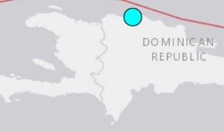
| 4.2 |
| 26 Jul 2020 08:53:17 UTC 26 Jul 2020 04:53:17 near epicenter 26 Jul 2020 04:53:17 standard time in your timezone |
| 18.725N 69.422W |
| 93 km |
| 8.0 km (5.0 mi) SE of El Puerto, Dominican Republic 17.9 km (11.1 mi) WSW of Hato Mayor del Rey, Dominican Republic 18.8 km (11.7 mi) N of Quisqueya, Dominican Republic 22.7 km (14.1 mi) E of Bayaguana, Dominican Republic 32.3 km (20.0 mi) NNW of San Pedro de Macor�s, Dominican Republic |
| Horizontal: 7.5 km; Vertical 7.7 km |
| Nph = 36; Dmin = 8.1 km; Rmss = 0.42 seconds; Gp = 87° Version = |
us 6000b4bb
 |
- Thread starter Cdn_Gringo
- Start date
You are using an out of date browser. It may not display this or other websites correctly.
You should upgrade or use an alternative browser.
You should upgrade or use an alternative browser.
Earthquakes in the DR

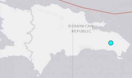
| Preliminary Report | |
| Magnitude | 4.2 |
| Date-Time | 25 Aug 2020 10:26:22 UTC 25 Aug 2020 06:26:22 near epicenter 25 Aug 2020 06:26:22 standard time in your timezone |
| Location | 19.811N 71.267W |
| Depth | 10 km |
| Distances | 9.9 km (6.1 mi) W of Estero Hondo, Dominican Republic 20.3 km (12.6 mi) ENE of Villa V�squez, Dominican Republic 29.3 km (18.2 mi) ENE of Las Matas de Santa Cruz, Dominican Republic 34.9 km (21.7 mi) NW of Mao, Dominican Republic 37.7 km (23.4 mi) NNE of Sabaneta, Dominican Republic |
| Location Uncertainty | Horizontal: 3.5 km; Vertical 2.0 km |
| Parameters | Nph = 26; Dmin = 70.7 km; Rmss = 1.07 seconds; Gp = 103° Version = |
| Event ID | us 7000bck3 |
Posted as a reminder that the shaking from an earthquake is not the only threat our island nation faces when it comes to these events. Nothing to worry about from this earthquake but this may not always be the case. Of particular concern is the major fault that runs east to west in the ocean off the north coast of the island - the North Hispaniola Fault and portions of the Puerto Rico Trench. Both of these areas of active seismic activity are thrust zones that are more than capable of producing a large tsunami under the right conditions. Fortunately this quake was nowhere near us. These large destructive waves can travel large distances quite quickly. As far as I know the Dominican Republic has no tsunami early warning system in place to notify citizens of inbound threats.
PRELIMINARY EARTHQUAKE PARAMETERS
---------------------------------
* MAGNITUDE 6.6
* ORIGIN TIME 0651 UTC SEP 6 2020
* COORDINATES 7.5 NORTH 37.1 WEST
* DEPTH 10 KM / 6 MILES
* LOCATION CENTRAL MID-ATLANTIC RIDGE
EVALUATION
----------
* AN EARTHQUAKE WITH A PRELIMINARY MAGNITUDE OF 6.6 OCCURRED
NEAR THE CENTRAL MID-ATLANTIC RIDGE AT 0651 UTC ON SUNDAY
SEPTEMBER 6 2020.
* BASED ON ALL AVAILABLE DATA... THERE IS NO TSUNAMI THREAT TO
CARIBBEAN COASTS FROM THIS EARTHQUAKE.
-------------
"A dozen major earthquakes of magnitude 7.0 or greater have occurred in the Caribbean near Puerto Rico, the U.S. Virgin Islands and the island of Hispaniola, shared by Haiti and the Dominican Republic, in the past 500 years, and several have generated tsunamis. The most recent major earthquake, a magnitude 8.1 in 1946, resulted in a tsunami that killed a reported 1,600 people."
when was the last time we had a Tsunami rolling towards the DR on any coastline?
while everybody knows that a big Quake could happen unpredicted at any time at any moment,
those shown small and usual shakes are zero indicator for such.
if it hppens it will happen, from one moment to an other and there will not be any escape.
thats life with natures normal dangers around it.
observing those weekly shakes and hyping up the stuff is likewatching clouds over East Africa and start calculating possibilities of a tropical storm forming out of that for 3 weeks later.
I am told that if you go out a few miles off the north coast, there are shallows where you can stand.
The mountain range underwater near or at the fault
I believe that fault continues west and joins the San Andreas fault line
The mountain range underwater near or at the fault
I believe that fault continues west and joins the San Andreas fault line
yes.I am told that if you go out a few miles off the north coast, there are shallows where you can stand.
The mountain range underwater near or at the fault
I believe that fault continues west and joins the San Andreas fault line
we also have wide shallow areas several miles out here off the East.
fantastic fishing grounds for white marlin season those 20-25 fathom shallows/bathtubs, where here also different mayor currents hit.
those are super calm in the middle of a wavy ocean, small fishies trapped in the area in very warm waters, Predators love that seafood buffet and visit for long months from March til into August.
just a few milesfrom there we have super deep points at the 3 Rocks Canyons, just 12.5nms off the Marina Entrance.
the Ocean around the Island is a beautiful Canyonland with very deep and super shallow wide areas.
Thanks
Happy to have that confirmed
There is a boat in Rio San Juan called Marlin Chaser
They rent out fishing charters.... American owner
Happy to have that confirmed
There is a boat in Rio San Juan called Marlin Chaser
They rent out fishing charters.... American owner
I felt the jolt and my dog got off his bed and went under mine.Posted as a reminder that the shaking from an earthquake is not the only threat our island nation faces when it comes to these events. Nothing to worry about from this earthquake but this may not always be the case. Of particular concern is the major fault that runs east to west in the ocean off the north coast of the island - the North Hispaniola Fault and portions of the Puerto Rico Trench. Both of these areas of active seismic activity are thrust zones that are more than capable of producing a large tsunami under the right conditions. Fortunately this quake was nowhere near us. These large destructive waves can travel large distances quite quickly. As far as I know the Dominican Republic has no tsunami early warning system in place to notify citizens of inbound threats.
PRELIMINARY EARTHQUAKE PARAMETERS
---------------------------------
* MAGNITUDE 6.6
* ORIGIN TIME 0651 UTC SEP 6 2020
* COORDINATES 7.5 NORTH 37.1 WEST
* DEPTH 10 KM / 6 MILES
* LOCATION CENTRAL MID-ATLANTIC RIDGE
EVALUATION
----------
* AN EARTHQUAKE WITH A PRELIMINARY MAGNITUDE OF 6.6 OCCURRED
NEAR THE CENTRAL MID-ATLANTIC RIDGE AT 0651 UTC ON SUNDAY
SEPTEMBER 6 2020.
* BASED ON ALL AVAILABLE DATA... THERE IS NO TSUNAMI THREAT TO
CARIBBEAN COASTS FROM THIS EARTHQUAKE.
-------------
"A dozen major earthquakes of magnitude 7.0 or greater have occurred in the Caribbean near Puerto Rico, the U.S. Virgin Islands and the island of Hispaniola, shared by Haiti and the Dominican Republic, in the past 500 years, and several have generated tsunamis. The most recent major earthquake, a magnitude 8.1 in 1946, resulted in a tsunami that killed a reported 1,600 people."
The passengers in the back of this car felt it too.
I know the boat.Thanks
Happy to have that confirmed
There is a boat in Rio San Juan called Marlin Chaser
They rent out fishing charters.... American owner
the captain Jose is Dominicn or Dominican American, he speaks spanish and english fluent.
the boat been fishing for a while here around my turf, too, at Punta Cana Marina.
the Marlin Chaser is a Catamaran, btw, Twin Suzuki Outboards if i remember correctly.
Can't say - Owner has a house in Cabrera --- not Jose, he's an employee
Yup - twin engines
Yup - twin engines
when was the last time we had a Tsunami rolling towards the DR on any coastline?
I believe the article I linked to in my post mentions 1946 with 1600 casualties. Don' tknow if that was DR specific or not.
CG
Are you counting the ways you can die or be killed ?
A new one every day almost !!!
Try listening to Peggy Lee.....
Is That All There Is
Are you counting the ways you can die or be killed ?
A new one every day almost !!!
Try listening to Peggy Lee.....
Is That All There Is
1946?
no satelite observations, no seismographic observations like todays, no internet or TV where about some stuff been warned.
of course in such times people got caught by surprise, by Hurricanes the same as by Tsunamis and other stuff, as nobody knew when such happened until it was there and hit and killed everybody along the beaches of the islands.
why waste life on worries about things that may happen every 50 or 100 years?
| Preliminary Report | |
| Magnitude | 4.6 |
| Date-Time |
|
| Location | 19.113N 69.582W |
| Depth | 10 km |
| Distances |
|
| Location Uncertainty | Horizontal: 4.3 km; Vertical 2.0 km |
| Parameters | Nph = 36; Dmin = 41.6 km; Rmss = 1.28 seconds; Gp = 136° Version = |
| Event ID | us 6000c9dc |
| Preliminary Report | |
| Magnitude | 4.2 |
| Date-Time |
|
| Location | 18.666N 70.767W |
| Depth | 10 km |
| Distances |
|
| Location Uncertainty | Horizontal: 1.5 km; Vertical 1.9 km |
| Parameters | Nph = 16; Dmin = 65.1 km; Rmss = 0.88 seconds; Gp = 82° Version = |
| Event ID | us 7000ckc2 |
| Preliminary Report | |
| Magnitude | 4.6 |
| Date-Time |
|
| Location | 18.205N 71.456W |
| Depth | 10 km |
| Distances |
|
| Location Uncertainty | Horizontal: 4.6 km; Vertical 1.9 km |
| Parameters | Nph = 73; Dmin = 20.4 km; Rmss = 1.04 seconds; Gp = 33° Version = |
| Event ID | us 7000cl4u |
| Preliminary Report | |
| Magnitude | 4.0 |
| Date-Time |
|
| Location | 18.645N 68.987W |
| Depth | 137 km |
| Distances |
|
| Location Uncertainty | Horizontal: 3.7 km; Vertical 2.0 km |
| Parameters | Nph = 52; Dmin = 68.9 km; Rmss = 0.59 seconds; Gp = 157° Version = |
| Event ID | pr 2021021001 |
Attachments
In 1946. It was of 8.0 magnitude and affected the Northeast (Matancitas, Nagua, El Juncal and Punta Morón). 1,970 people lost their lives.when was the last time we had a Tsunami rolling towards the DR on any coastline?
while everybody knows that a big Quake could happen unpredicted at any time at any moment,
those shown small and usual shakes are zero indicator for such.
if it hppens it will happen, from one moment to an other and there will not be any escape.
thats life with natures normal dangers around it.
observing those weekly shakes and hyping up the stuff is likewatching clouds over East Africa and start calculating possibilities of a tropical storm forming out of that for 3 weeks later.
| Preliminary Report | |
| Magnitude | 4.4 |
| Date-Time |
|
| Location | 19.840N 71.054W |
| Depth | 10 km |
| Distances |
|
| Location Uncertainty | Horizontal: 4.1 km; Vertical 1.9 km |
| Parameters | Nph = 25; Dmin = 57.1 km; Rmss = 0.87 seconds; Gp = 109° Version = |
| Event ID | us 6000dk39 |