hurricane season 2017

Status
Not open for further replies.

william webster

Rest In Peace WW
Jan 16, 2009
30,246
4,333
113
If you get bored Mike....

You could start an earthquake watch thread..........
Shake things up a bit !!!

hahaha
 

MikeFisher

The Fisherman/Weather Mod
Feb 28, 2006
13,896
2,486
113
Punta Cana/DR
www.mikefisher.fun
If you get bored Mike....

You could start an earthquake watch thread..........
Shake things up a bit !!!

hahaha

lol,
better not.
we have so many quakes in our surroundings,
such thing would scare people to death for nothing.
a lil shake here or there is nothing to write home about.
on the otha hand, some daily observed b..-shakes on the Beach here are worth mentioning,
but then comes DR1-Mod to remind us about Family Friendly Content, lol.

Mike
 

MikeFisher

The Fisherman/Weather Mod
Feb 28, 2006
13,896
2,486
113
Punta Cana/DR
www.mikefisher.fun
so the Disturbance is declared TD4 now.
same positioning,
same small TS Areas and all locatd wel west of the Center.
same expected directions of movements WNW.
at this moment i don't see anything we would need to look out for on the Highway.
know what, it's almost weekend again ...

Mike
 

Marilyn

Bronze
May 7, 2002
728
22
18
Africa is looking interesting, GFS and EURO models "predict" a hurricane in the caribbean for late next week, a little too early I think, large margin of error...

DEIeqM8VwAEZdZT.jpg


DEIlP38VwAACozv.jpg


DEIlZHJUQAAkhs-.jpg
 

MikeFisher

The Fisherman/Weather Mod
Feb 28, 2006
13,896
2,486
113
Punta Cana/DR
www.mikefisher.fun
it is early for big hurricanes mid July but they happen.
that we have tropical waves leaving the african continent is normal this time of year.
we have to wait til each hits Atlantic Waters over there,
to see what potential is hiding in each and to see the then present conditions on the pavement.
TD4 is as awaited already struggling, it was too weak from the beginning.
since last evening the central pressure rose 3mbar, a sign for loosing powers.

Mike
 

MikeFisher

The Fisherman/Weather Mod
Feb 28, 2006
13,896
2,486
113
Punta Cana/DR
www.mikefisher.fun
still shown as TD4 on the outlooks,
TD4 doesn't look like a Storm to me by any means anymore.
let's call it a Weeeeekend!
sunshine, beach, drinks and bikinis
and don't forget to stock on those drinks, it will be a hot one

Mike
 

MikeFisher

The Fisherman/Weather Mod
Feb 28, 2006
13,896
2,486
113
Punta Cana/DR
www.mikefisher.fun
good morning y'all.
quiet some activity out on the weather front on both sides of the Highway.
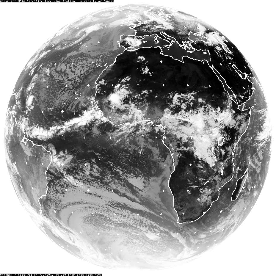
* we have a heavy weather/Thunder Storm Area parked right off the Northshores,
chances for some cooling wet are high there during today.
it is Not something that will develop into anything further.
* we have a strong heavy weather area over the northern Island-belt/NE of Puerto Rico.
it is not developing to anything, but depending on it's final directions it could bring strong winds towards the NE Shores,
but most likely effects will not reach DR-Soil.
* the Tropical Wave on the Maps since last evening, now a few hundred miles SW of the Cape Verde's,
is at this point of no concern. poor organized with little TS Activity it runs on 20mphr westward.
thelow and mid Atmosphere are fairly stable out there and it will race over fairly dry grounds.
we will take a look on the forecasted conditions ofthe Western Highway by mid week,
to see if that one could become something, by then it will be Mid-Highway/half way over here.
at this point i do not see anything of concern coming out of that one, but it's early to say it def.
* we have an other wave emerging from the African Continent this morning.
it is too young to say anything about movement/powers/develoment.
the Reason why i mention both waves so early is a 3rd one, actually wandering over Central Africa.
so we have a early in the Season little line up.
the effects of such line ups:
the first is bringing some movement to our actually stable low/mid Atmosphere and sucks up some dry Air.
the 2nd right behind messes up the Atmosphere's stability and starts to moisture the grounds on mid level.
all that without any fear of a dangerous Storm developing or coming anywhere close to us.
But then comes the Biach, number 3, actually over Mid Africa, hitting Atlantic waters SE of the Cape Verde's later this week.
at the mment it is only Big and Wet.
if it is the same big and wet when hitting the Atlantic in a few dys And mingles with a slight Spin,
Then we could see the first developing Storm on the Eastern Highway this early Season,
as the first 2 Waves moisture the Path, mess up our stable Atmosphere and take away part of te protecing Dry Airmasses.

But no Panic,
this is just a long range theory in the Fisherman's head.
weekend was fine with friends over here for some chats 'n'beers,
all work on the new website and mobile app is finished after weeks of a burning head,
so i need something to not get too bored these days, lol.

Mike
 

MikeFisher

The Fisherman/Weather Mod
Feb 28, 2006
13,896
2,486
113
Punta Cana/DR
www.mikefisher.fun
the Disturbance on the Highway went dry very quick and dissipated.
looks all nice stable out there.
what is extremely wet it the Powers which been located all day long yesterday, since the night before, NE of Puerto Rico.
all the time stationary, not moving anywhere.
today N of the easten side of PR it is a tad bit closer to the neighbour's northshores.
that area of heavy weather is expanding ad sending out strong winds and hety rainfalls on quiet adistance out.
nothing out there to keep 2 eyes on at the moment.
the wave S of the Cape Verde's looks weak at the moment
and the Atmosphere over the Highway is for most parts fairly dry and stable.
til now the waves could not manage to prepare the pavement for a Run.

Mike
 

MikeFisher

The Fisherman/Weather Mod
Feb 28, 2006
13,896
2,486
113
Punta Cana/DR
www.mikefisher.fun
time for a lil update this weekend, even that nothing important is anywhere near nor expected to pop up.
the Dysturbance mid Highway, running the southern lne Westward at 15mphr,
is a small weak system with barely mentinable moisture to collect in vicinity.
it is fighjting a stable mid athmosphere and a very dry environment.
if it manages to become a weak Storm in the first place, it will not get much chances to develop.
surroundings are better over the Caribbean Sea,
but i don't give it a chance to rech the SE'ern Caribbean Sea as a working Storm that could start a good fueld machine to develop into a real Storm.
looks all good for our Isle.
have a great sunny weekend y'all

Mike
 

MikeFisher

The Fisherman/Weather Mod
Feb 28, 2006
13,896
2,486
113
Punta Cana/DR
www.mikefisher.fun
nothing out there which could bother sunday drinks and BBQ for this weekend
nor anything that would be expected a threat for our Isle during the coming week.
the areas around the Island Belt lost lots of the dry air masses but are still too dry to give a weak system a chance.
windshear shows some open spots but for most areas on our SE is expected to stay in the mid-force range,
again enough to not assist a weak system for much of development.
the Invest on the southern Lane, about 1000 miles off the Windwards,
may show some but no significant power gains the next days out.
on tuesday or wednesday it should be on approach of the southernmost Islands, If still alive,
we will have an other look then.
it's sunny,
it's sunday,
Ribbs smell,
beers are cold,
nothing else matters.
Island Life is GOOOOD.
have a great one

Mike
 

MikeFisher

The Fisherman/Weather Mod
Feb 28, 2006
13,896
2,486
113
Punta Cana/DR
www.mikefisher.fun
tropical storm don has formed, 4th this season:
https://www.diariolibre.com/medioam...pical-don-la-cuarta-de-la-temporada-DD7647173

what's the scoop, mike? will it finally bring some clouds so i can run and cycle without burning through circles of hell?

thats why I run and cycle inside the house, between Office and beer fridge and BBQ, to not burn, because you can never rely on any ****ty storms to bring some cloudy relief, at least not over here in Punta Cana, lol.
I didn't await Don to form that quick/early, but still no concern for our Isle.
TS Don is wandering the southern Lane on approach for the Windward Islands,
what ever it will be once in the caribbean Sea, it should stay far south of us,
bringing more wind to the nothshores of the southamerican continent than clouds to our region.
the 2nd disturbance a few hundred miles behind Don was the more interesting one,
as the last TD and TS Don did moisture the highway well down there for a "next one" to follow to get nice conditions for gaining powers, but that "otha" disturbance is on a NW-Move and will most likely not come close to the Island Belt, more likely running a lot northwards into the actually Dry surroundings.
i don't think we will get to watch anything soon, at least not close enough to see it with our eyes or to get relief by it's clouds.

Mike
 
Status
Not open for further replies.