hurricane season 2017

Status
Not open for further replies.

MikeFisher

The Fisherman/Weather Mod
Feb 28, 2006
13,896
2,486
113
Punta Cana/DR
www.mikefisher.fun
AE,
Yes, of course the south should get it's share, too.
when we get some clouds on the Eastern Cape from something off the South,
then the South Shores getthatand a lil bit more form the same thing.
nothing to worry about, it is all far away, we just get the farest spread out cloud bands
and after it passed of course the Ocean will bring the waves to the shores along the South.
the SE anyways was very rough this week i guess, as heavy weather moved over the corner of Saona/Yuma/Bayahibe,
the rain and wind effects due Harvey should be less intense there.

Mike
 

MikeFisher

The Fisherman/Weather Mod
Feb 28, 2006
13,896
2,486
113
Punta Cana/DR
www.mikefisher.fun
what a beautiful Sat afternoon here on the East.
it is 5:30PM and i am now facing the hard work to go to the Beach and get the girls out of the water.
by Lunch they already only came up by Force, of course nobody was hungry, lol.
it will be Wartime now around here.
all actually running stormy formations out there are dying, on their way to Stormy Heaven.
let 'em get their Virgins, I say ...
asie of the short few minutes soft shower i mentioned this morning, not a drop of rain here all day long.
we had some light cloudy moents before Noon, but nothing that could have bothered a perfect beach day.
Offshore Sea is rough south of the Cape, just a bit above average north of the Cape.
the weekend should continue that way,
nothing bad in sight
have a great one

Mike
 

MikeFisher

The Fisherman/Weather Mod
Feb 28, 2006
13,896
2,486
113
Punta Cana/DR
www.mikefisher.fun
playing around.
here is a Caribbean wide view of Waterloads detected by all caribbean Radar Stations.
Thanks to the perfect pro technical equipments on Goudaloupe and Martinique and Barbados(actually out of service til septeber due a missing piece that got damaged a while ago, DR Parcel Service is sure the shipping company, lol), they provide long range 400 Km Radius Radar coverage of the top art, Puerto Rico with it's short range Radar Station in San Juan covering only their own Soil, DOMINICAN REPUBLIC as the stupid cheap azzes not running any Radar Station at all, hence the blanc space for the whole West of our territory and above and below our Island, shame on the cheap Corrupts taking all in the own pockets, and Cuba with a great coverage around their Territories and all providing their full Data publically to everyone who wanna see it.

this photo is the standing from 5:15PM Today,
it shows all Waterloads(not much to see, yep) moving around.

Mike


august 19th 2017 0515PM full caribbean radar combo.jpg
 

MikeFisher

The Fisherman/Weather Mod
Feb 28, 2006
13,896
2,486
113
Punta Cana/DR
www.mikefisher.fun
right now, after 2AM, we have some rain on here on the Eastshores.
but as seen onthe Sat Loop, it is just a small splitter of ex-Harvey, nothing mayor.
but look wjhat is coming from the right side, a southern-pushed cut-off portion of Disturbance 92.
looks like it will walk right over PR and continue over here.
we will see soon what water it has left after it passed PR, it could provide long hours of strong rainfalls.
I guess that 92 will makem Caribe Mike's BBQ tomorrow a Singing in theRain Event.

time for a nap, i hope there's no rain in the morning over here, so i can take advantage of the mud stuff on a Dirt Bike ride along the Cape.

Mike


wv-animated.gif
 

MikeFisher

The Fisherman/Weather Mod
Feb 28, 2006
13,896
2,486
113
Punta Cana/DR
www.mikefisher.fun
over all it was 3 short 15 minutes showers without significant wind last night here on the East.
today we are on a very calm no wind perfekt sunny beach day over here.
the remaints of Harvey are History for our territory.

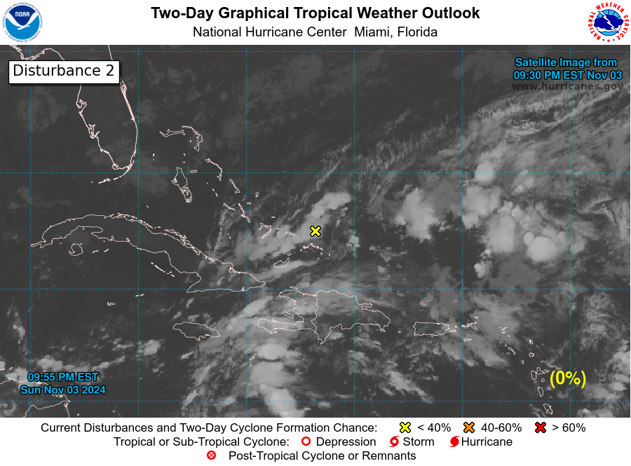
the Disturbance north of PR carries quiet some waters far on it's south, even reaching south of PR.
will be close to get showered by it or not here on the southern tip of the East.

nothing bad out there, keep this perfect sunday moving

Mike


two_atl_2d2.png
 

MikeFisher

The Fisherman/Weather Mod
Feb 28, 2006
13,896
2,486
113
Punta Cana/DR
www.mikefisher.fun
No Troubles anywhere out there for our Island,
here on the East we are on perfect beach days, calm and hot hot hot.

Ex-Harvey from our City limts, Reborn as Harvey in the Bay of Campeche,
is quiet a compact wel developing Cyclone on low pressure as a Cat1.
Conditions in the western Gulf, where he now wnaders towards Texas, are perfect for a quick Grow Up on Powers.
this Harvey should be a powerful Mayor Hurricane by mid morning already, no later than tomorrow Noon
and continue to grow Powers on top of the Mayor Hurricane Status for a good 12hrs
to hit the Texan Central Gulf Coast aroud midnight tomorrow night very hard and without any brakes on.
there is nothing on it's way to knock down powers, the opposite, from now til it's Touch Down it will grow powers by the hour and it will not go downwards qickly once over land, i expect Harvey to spend the weekend over land in Texas and even til deep into next week, as long as tuesday or even wednesday.
those Cowboys witin 100 miles from the Ocean better are on their way waaaay far out there by now.

the ole Disturbance, that passed to our North a while ago, is still out there and active over Florida.
while it has no chance to become a Storm with a number or name,
it is a dangerous waterload and South and Central Florida will not face any drought conditions this month,
that System will provide heavy floodings all around along it's path, itis exactly the kinda system that would be deadly for our own Island, much worse than a TS or Hurricane straight hit, as that stuff moves very slow and pours down all imaginable water powers for a looong while.

for our own Soil nothing bad in sight/awaited/expected for the next several days ahead,
so let's enjoy the sunny hot skies, cold tasty drinks and Bikinis on da Beaches as long as we have such fabulous conditions.

stay safe and far away from the Coast in Tx

Mike
 

MikeFisher

The Fisherman/Weather Mod
Feb 28, 2006
13,896
2,486
113
Punta Cana/DR
www.mikefisher.fun
All looks fine around this sweet lil Isle
and all should stay nice for the next days to come/at least til mid week.
I have no comments on Harvey or the TD in FL, as i did not follow up on either far away Storm.

we have a new Disturbance that just hit the road on 20mphr westward this evening on the Eastern Highway,
it will be investigated the next days about possible development or whatsoeverthingy.

if this Map doesn't show in full width til Africa, do a right mouse click and select "show in new window",
so it will show up as the full Map on full size.
two_atl_2d0.png


here is the Map of our actual SAL(Saharan Dry Sand Masses in the Air),
it is as protection actually only present over the mid Highway,
no protection over the last 1000 mls of the Stom Approching Route and not present over the Caribbean Sea.
splitEW.jpg


as shown on this graph, mid athmosphere is for most part moistured/wet pavement.
(same as first Graph, to se the complete Map do right mouseclick and select "show in new window", so it will show up complete/full size in a new browser window.
wv-animated.gif


the Windshear over the Western Highway and the Caribbean Sea.
this Variable has to be taken from day to day, it changes/shifts often and quickly.
at this moment in case of windshear and moisture the last 1000 miles approaching the Island Belt
and the Eastern Caribbean Sea would favor a Strom to quick and strong development.
wg8shr.GIF


at this time we Islanders have nothing to fear other than Sunburns or that the Presidente delivery Truck could have an accident on the way to our restocking Colmados.

have a great new week everyone

Mike
 

CG

Bronze
Sep 16, 2004
1,033
185
63
A BIG thank you to MikeFisher - Great maps and descriptions for a better understanding of the approaching weather to our lgr piece of dirt that we call home ...  

THANK YOU MIKE !!
 
Last edited:

william webster

Rest In Peace WW
Jan 16, 2009
30,246
4,333
113
The beer truck drivers read Mike's posts.... to avoid accidents !!

Good going Mike.

Technical jargon first and finish with plain English.
 

MikeFisher

The Fisherman/Weather Mod
Feb 28, 2006
13,896
2,486
113
Punta Cana/DR
www.mikefisher.fun
good monday morning stormy world, what ever could be good on a monday,
other than the fact that it is one day less til weekend.

Invest 93, on the NOAA Maps named Disturbance1,
is a monster of a wide fat waterload which already this early shows heavy TS Activity on many fronts.
once it passed the 25th"West we should get an idea about the general Steering/Heading.
the only Dry Saharan Sand Airmasses are located over the mid Highway, which would hinder/bother development for a couple days. the System looks very active, but due it's size i doubt that it can develop into a Depression/TS before hitting the Dry Air Zone. if it would get organized, such wide organized area would suck up and spit out the dry wall like nothing, just walk through.
my guess goes on today and tomorrow forming together as a very wide area of waterloads with active TS Zones,
but not reaching the organization to become a Storm.
then crawling through the dry air masses for a day or 2, development on hold durin that time.
Then we have to see how conditions will be by then on the final may be 800 miles approaching the Island Belt
(keep in mind that Steering/Heading is not detreminded at this moment/now).

for the first half of this week we have nothing to watch out for,
it is Beach Time.

Mike
 

MikeFisher

The Fisherman/Weather Mod
Feb 28, 2006
13,896
2,486
113
Punta Cana/DR
www.mikefisher.fun
as seen on the Floater over Invest 93L in Post 193,
that Disturbance is a active one and got quickly organization to show.
conditions out there on the far East are actually good for further development the next few days,
so we should see Storm number 11 out there later this week.
it has dry Saharan Sand Masses to it's NW and W, but they are actually not very thick,
a fat moisturous Storm may stand that and walk through.
on our end of the Highway our protection shield is forming up,
the Eastern Caribbean Sea is since this morning under hostile Windshear and the same high Windshear areas are moving down to cover the last 1000 miles of the Runway for any arriving Storm from the East,
so we will not get anything dangerous up on our East or the Caribbean Sea for several days now.
93L will by actual Data never become a threat for our Paradise Isle.
it is at the Cape Verde's already Centered near the 15th"N,
so the typical Westward Heading with a northwards drift will let it miss the Island belt well far to the NE, by actual early standings, sure we will keep an eye on it for a few more days to see the directional patterns.
what it sure will cause is to suck up the already tiny and weak dry air barriers over mid Highway,
paving the runway for what ever may come within a few days later in it's wake.
93L is by now wet but weak on TS on it's south, ultrawet and very powerful on TS on it's N and NE'ern quadrants,
so i guess the Cape Verde's will not suffer of any drought for a while.
the next big Wave, now located over Central Africa, seems to get a more southern positioning for a touch down over Atlantic Waters in maybe 4days or so/early next weekend.
it will be a close call to get any dry air masses shield up again that quick,
but by now we don't know if that wave will be a active/hostile/stormy one or just a Pufff once reaching wet grounds.
nothing in between those 2 Waves and nothing awaited to pop up around eastern directions.
our Island is for more days on the sure safe side of H-Season Life.

Mike
 

MikeFisher

The Fisherman/Weather Mod
Feb 28, 2006
13,896
2,486
113
Punta Cana/DR
www.mikefisher.fun
Invest 93L is a well defined Storm with plenty of TS Force windsall around.
it sure will be declared TD11 at any moment this morning or even get the next name on the list right away.
it got organized very quick and has the potential to easily wander through the anyways tiny Dry Air Fields on it's path,
so by actual standings of conditions over the Highway we should observe the next Big One Forming during the next 5 Days.
it's Tracking/Heading i see today the same as described yesterday,
it is moving W-WNW and should miss the Islands on the NE, but that far away and still in development the Tracking of course could change, as small Systems get their Heading influenced by different currents than Big Powerful Hurricanes, who reach much higher up into the Atmosphere and get pushed by the wind curents up there, while smaller/not high up reaching Storms get pushed by the mid Atmosphere and Surface wind currents, which are the typical Westward ones with a light nortehrn drift,
hence W-WNW.
sure the whole Caribean has to watch this for the next several days, until it is close enough to be clear about a Miss or Hit,
but by now I do not see inhabited areas under threat, at least not over here in the Caribbean.
a further path towards the US is far too early to guess about, that will be something to look on next week.

we are under perfect sunny skies and ultra calm here on the East,
so let's enjoy that sweet Island Beach Life without worries.

Mike
 

Drake

Bronze
Jan 1, 2002
669
24
18
Irma's track dips SW on Saturday which does not look good for Hispaniola. Big system warm seas not good
 

MikeFisher

The Fisherman/Weather Mod
Feb 28, 2006
13,896
2,486
113
Punta Cana/DR
www.mikefisher.fun
Irma is a biach with all potential for a very strong Beast.
it should be a Hurricane by tomorrow evening.
i am just home from a quick ride to Higuey, saw the southern dip prognosted for saturday,
i don't know where that dip comes from, most likely it is awaited that Irma will be a powerful fueling machine by then and start to run with the higher elevations winds then on, which wouldbe a Mayor Cyclone for the Caribbean heading for the central Island belt entering the caribbean Sea around/a bit more north of the position where Harvey came into theCaribbean Sea. but Harey was a small low powers formation, Irma should be awaited to be a real Big and to Fear Machine in just a few days from now. i guess the calm times may get a interruption soon. will take a look later today.
the currents over the eastern caribbean Sea, which decide directions once in the Caribbean, are not forecastable at this time, anyways not that far ahead of time, as they been shifting permanently all the time since last week.
hence yesterday we had early morning highest hostile windshear present, this early morning today it was down on lowest levels, nothing is on a stable/predictable pattern there.
it is still far away, later on we take some time to have a closer look.
for now, Irma will be a bad one, where ever it will hit, not a lil Harvey from Tx.

Mike
 

MikeFisher

The Fisherman/Weather Mod
Feb 28, 2006
13,896
2,486
113
Punta Cana/DR
www.mikefisher.fun
Irma should become powerful and change Tracking.
once reaching high enough into the Atmosphere the upper currents take over and push it towards the Caribbean Islands/Sea.
on the tracking map such will look like a "Turn SW'wards".
continuing actual well development with awaited quick intensification would bring us a very strong Cyclone into the Caribbean Sea next week.
let's enjoy the calm nice days now, as we could get into a mor action-like game mid next week.
we have to watch this one all the time, specially once it became Powerful and shows it's "Turn" on Heading.

Mike
 
Status
Not open for further replies.