2015 Hurricane Season

Status
Not open for further replies.

william webster

Rest In Peace WW
Jan 16, 2009
30,246
4,333
113
only after I empty it.....

did you mess with my post.... techno genius ??

RAIN, I asked for .... but wine will be appreciated during the storm
 

MikeFisher

The Fisherman/Weather Mod
Feb 28, 2006
13,896
2,486
113
Punta Cana/DR
www.mikefisher.fun
only after I empty it.....

did you mess with my post.... techno genius ??

RAIN, I asked for .... but wine will be appreciated during the storm

hey Will,
Gringo metioned in a prior posting, the he is capable of using a Suape,
so after you survived in the wine cellar, he could come by and clean up to get (after his departure) the place restocked.
sometimes those canuck gringos really could be of some serious help, lol.

Mike
 

MikeFisher

The Fisherman/Weather Mod
Feb 28, 2006
13,896
2,486
113
Punta Cana/DR
www.mikefisher.fun
from the good wine back to ex-Biach Danny.
i mentioned twice today that it looks like a struggling storm,
and at this moment i would say it was the right observation.
Danny for this moment, is almost Gone.
TS activity insignificant,
no more spin on anything,
he is a Sankie with a Gringa who has no Western Union Account.

the odds for a dying storm to recover and come back, sometimes even as a stronger bugger than previously shown, are of course still out there.
but to me,
comparing the different outlooks on dryness in the mid atmosphere, missing connection to significant amounts of moisture, disappeared TS activity, lost spin,
to me Danny lost the game in round one and will be disqualified for playing any further round.
the original wave of course still exists,
there is always a slight chance of a come back,
but in case of Danny i don't believe such.
i awaited it to gain some additional forces during thursday/tomorrow,
so it may show a "almost" come together again, even with higher windforces shown on the Maps,
but i do not await it to come back to become a organized storm with center and build up TS areas and to show a real spin around a well defined center.
it is DEAD.
before the weekend there will in my opinion no name Danny on the maps anymore,
not for this season.

let's enjoy sunny beache Days and every otha day clouded(sometimes luckily even Rainy) evenings/nights til the weekend,
next week we can start to observe the next formations moving about the far eastern highway,
there are actually 3 nice looking Waves over the african mainland, which should start to hit atlantic waters in a few days.
what, IF any, comes out of them, we will find out by the time they move over the wet pavement of the highway.
nothing of concern,
it is every year at this time of the year exactly that,
waves leave the african mainland and hit atlantic waters westward-hooo, da Highway.
this year, and prooved til now,
the conditions over that highway are not very favorable for stormy development.
10-20 hrs of showing some small muscles, but then the Viagra times out and William Webster keeps the wine cellar closed for fellow Canuck Intruders, lol.
it is all fine around.

Mike
 

donP

Newbie
Dec 14, 2008
6,942
178
0
Still A Spinning Storm

...Danny for this moment, is almost Gone.
TS activity insignificant,
no more spin on anything,...
before the weekend there will in my opinion no name Danny on the maps anymore,...

NHC sees it differently:
"500 AM AST THU AUG 20 2015
The cloud pattern resembles a tropical cyclone much more than 12 hours ago... and the center continues to be remarkably well depicted... it has a much better structure than earlier.... Danny has the opportunity to strengthen a little during the next 2 to 3 days. .."

Thus the Leeward Islands may experience a strong TS or even an H1.

http://www.accuweather.com/en/weath...th-to-tropical-depression-four-danny/51857239

We, however, could be lucky and only get rain from the remnants of the system. :bunny:

donP
 

Hillbilly

Moderator
Jan 1, 2002
18,948
514
113
Fisherman:
Like DonP says the 5 am ST report from NHC seems to think it will strengthen.
And the Mid-Atlantic satellite Rainbow shows a much smaller but spinning area.

I, too, want rain...rain, rain..

HB
 

donP

Newbie
Dec 14, 2008
6,942
178
0
Most Likely Not A Hurricane When Reaching the DR

I, too, want rain...rain, rain..

Rain, we shall get. :bunny:

The forecast for Monday shows an H1 just East of the Leeward Islands, then the system will hopefully lose strength.

dannyforecast2408_zpsdxeafoit.png


donP
 

william webster

Rest In Peace WW
Jan 16, 2009
30,246
4,333
113
hey Will,
Gringo metioned in a prior posting, the he is capable of using a Suape,
so after you survived in the wine cellar, he could come by and clean up to get (after his departure) the place restocked.
sometimes those canuck gringos really could be of some serious help, lol.

Mike

Gringo may be useless..... It's Bailey who really carries the pail...
 

donP

Newbie
Dec 14, 2008
6,942
178
0
Only A TD on Monday?

Different forecast, different scenario:

dannyas%20TD_zpsiox5mqwi.png


From this, it looks like that the South of the DR will 'benefit' more than the North...
All still very uncertain, though.

donP
 

william webster

Rest In Peace WW
Jan 16, 2009
30,246
4,333
113
I would expect a wide swath of rain (correct me, expertos) and would prefer a storm over a hurricane.

Where's bookie odds on this ?? they always know..... hehehe
 

PCMike

Active member
Aug 30, 2008
337
246
43
Let's hope it passes to the south giving us the moist air with rain...not the dry air return....we have had enough of that all year.
 

Hillbilly

Moderator
Jan 1, 2002
18,948
514
113
According to 11 am AST advisory, DANNY is now a Cat 1 hurricane....
DISCUSSION AND 48-HOUR OUTLOOK
------------------------------
At 1100 AM AST (1500 UTC), the center of the eye of Hurricane Danny
was located by satellite near latitude 12.5 North, longitude 44.8
West. Danny is moving toward the west-northwest near 12 mph (19
km/h) and this general motion is expected to continue for the next
couple of days.

Maximum sustained winds have increased to near 75 mph (120 km/h)
with higher gusts. Some additional strengthening is forecast during
the next 48 hours.

Danny is a small tropical cyclone. Hurricane-force winds only
extend outward up to 10 miles (20 km) from the center and
tropical-storm-force winds extend outward up to 60 miles (95 km).

The estimated minimum central pressure is 992 mb (29.30 inches).


HB
 

MikeFisher

The Fisherman/Weather Mod
Feb 28, 2006
13,896
2,486
113
Punta Cana/DR
www.mikefisher.fun
looks sound and nice round today.
it improved a lot from dying down to a much smaller but well spinning center.
let's see how long it lasts on such powers,
that central pressure went down a lot as it intensified a lot and fast due the well smaller size to move.
avn0-lalo.gif


bd_lalo-animated.gif


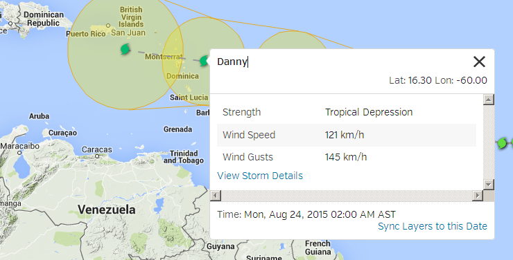
still struggling as to Where to keep da Eye.
it is not a strong walled of Center, it is a construction site and actually made of poor quality.
looks like DR ingenieurs supervising the construction of haitian labourers, lol.

ft-animated.gif


here you see the eyewall going down, starting a new one 30 minutes ago.
as the storm is small on size, it should not get too much troubles to do so.
that it is troubling on it at all is Goood, as it is a sign of struggles with something,
maybe dry air, windshear looks nice low tho.
rbtop-animated.gif


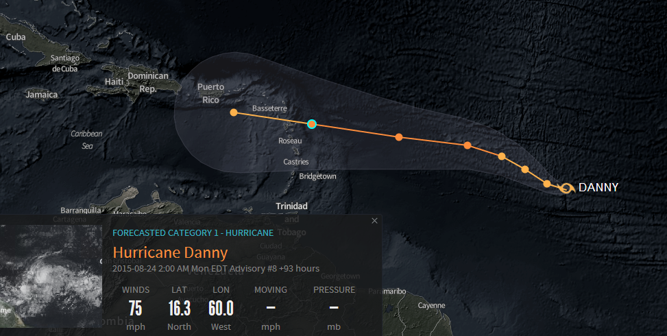
the storm should reach it's top powers tomorrow morning, they will stay below 80Knots as the maximum to gain.
he will not hold the max for long, 10hrs, maybe 20 hrs.
by saturday morning the windforce of Danny will already be on a decreasing tendency, after it crossed the 50thW.
sunday morning, by the actual speed running 55-57West, it should be down on the edge to get the downgrade as just a Tropical Storm already, and that's still East of the Islands, doesn't matter it wanders more westwards to enter the caribbean Sea or with a more northerly drift to miss the Islands on the NE completely.
the tracking is very uncertain so far ahead, as it depends on it's size reaching up into the atmosphere, to decide which level of winds will be the more dominating steering winds.
actual direction/steering would let me bet on a pass over the NE'ernmost Islands, with almost zero of any rain for Hispaniola,
but the models tend to bring it more Westwards, wandering into the caribbean Sea. if passing our southern shores close enough we could get rain in PC out of it, MAYBE.
for that tracking lines we need to wait til the weekend, it can change too much from now til then.
my bets are, that there will not be any hurricane named Danny entering caribbean waters or passing our Island anywhere near this season.
to me the storm is a Blender, it looks strong and quick increasing windspeeds since last night, but that's a Fraud, he sized down a lot, and solely due the downsizing he could gain windspeed, that Hurricane-Karma will bite it in da Arse and once it passed it's top powers, the road downwards will be a steep one.

Mike
 

MiamiDRGuy

Bronze
May 19, 2013
2,015
727
113
As of 12pm today, Weather Channel says Danny will make 80% landfall as of Tuesday next week at this location: Punta Cana

Then it will go west to Santinago to Putero Plata then go north towards the Atlantic Ocean.

This will end the drought in Dominican Republic, for sure.
 

Hillbilly

Moderator
Jan 1, 2002
18,948
514
113
I will cook some pork filets, ribs and chops..and half a case of good brew!!

My only worry is that Mike is so pessimistic,, and he is seldom wrong.

HB
 

MikeFisher

The Fisherman/Weather Mod
Feb 28, 2006
13,896
2,486
113
Punta Cana/DR
www.mikefisher.fun
til now nothing wrong with my earlier mentioned guess's,
and that far ahead of time, all is of course just guessing, even what the weather nets write, lol.
i did not find any source which would forecast Danny for so long ahead of time to mention punta cana or anything of Hispaniola.
at least, as for guessing,
the models agree now much closer with my guess of Tracking.
last night and this morning very little brought Danny to the northernmost islands, only as the northernmost edge of their lines, they suggerated Danny to enter the caribbean Sea.
now they agree a lil bit more with the Fisherman and show the storm towards the northernmost Islands of the belt.
on the track actually shown by the models, Danny could not become any danger for Punta Cana, as it would pass the northern Islands and the Virgin Islands and the from E-W the rough mountainous terrain of Puerto Rico.
a very small storm like this, could not survive one landmass hit after an other on such tracking, the mountains of PR would kick it's azz down to nothing, not even a TD left to cross the Mona Channel.
nice dream of rainclouds reaching our side of the channel, tho.
but my guess stays the same, unchanged.
no Storm named Danny will enter our soil.
it will go down on the timeline i described this morning,
and that weak lil rainy thing left by then, will pass NE of the Islandbelt,
Punta Cana would need to get superlucky, like winning the lottery, to gain any real rainshower out of Danny's remaints.
and it will not be more than some remaints of a ex-storm, IF it reaches anywhere close to Hispaniola in the first place.

so far this year, including Danny,
no special precautions for the boats necessary to plan.
in case of any suprises on it's movement/development we would take care of that last minute, a few hours prior to arrival.
byt again,
i do not believe that any Danny will have any/not even the slightest effect on our PC weather this year.

Mike
 

MikeFisher

The Fisherman/Weather Mod
Feb 28, 2006
13,896
2,486
113
Punta Cana/DR
www.mikefisher.fun
pressure drops slower now.
forward speed is down to slow 10mphr, that has the slight advance to sukc in a bit less dry air,
but is around the edgepoint where it will start to chum up cooler ocean water from the depths.
70Knots of windpowers now.
it is almost at it's max point.
maximum 5 more knots, up to 75knots i say,
and the bugger will be on it's tops.
he will not hold it's tops for more than 20 hrs then, most likely well less of a time frame,
and then the decreasing phase begins.
it will be a steep one with screaming wheels downhillwards.
i do actually not even see the eyewall anymore,
but that just may be due a too small of a eye-diameter, not always visible under cloudcovers on the sat shots.

Mike
 

MikeFisher

The Fisherman/Weather Mod
Feb 28, 2006
13,896
2,486
113
Punta Cana/DR
www.mikefisher.fun
here we have the first one of this season, which should could become worth to look out for.
i don't mean Danny in da middle of the Map,
and sure not the disturbance off the us-coast.
i mean the Tropical Wave which just hit now atlantic waters, coming off the westafrican coast.
nice positioned,
carries a good moisture load,
for the next 5+ days the pavement ahead is light wetted,
no sigificant amounts of dry airloads in the near vicinity,
Danny is preparing a Runway for take-off of the next wave.

Mike


two_atl_2d0.png
 

donP

Newbie
Dec 14, 2008
6,942
178
0
Early Development Is Good.

I like those waves to develop into storms early, far away in the east.
Then, they usually either veer off to the north or lose their strength on the way before reaching us (like Danny). :bunny:

donP
 
Status
Not open for further replies.