2020 Hurricane Season

Status
Not open for further replies.

Caonabo

LIFE IS GOOD
Sep 27, 2017
7,339
2,949
113
MODS: Can I suggest that when a hurricane is coming, you ask people to keep their posts "noise free", ie. no chat or jokes, just posts that people need to know relating to the hurricane. I think this has been the case in previous years. Plenty of other forums on DR1 where people can joke IMO.

Mr. Paul,
There is no hurricane coming towards RD. This event is classified as Potential Tropical Cyclone Nine.
Not an opinion. Just the facts. Noise free, especially for you.
 

caribmike

Gold
Jul 9, 2009
6,808
202
63


Greg Dee

@GregDeeWeather

·
2h

Here is the problem with #PTC9 or #Isaias: it's not tracking according to the forecast. It's moving due west, not WNW, or NW. I expect BIG forecast track changes today if this continues. #flwx #prwx

EeGUbOqXsAAEEGd
 
  • Like
Reactions: cavok

caribmike

Gold
Jul 9, 2009
6,808
202
63
If it moves west I think we might still be able to dodge a big part of it... fingers crossed.
 

Caonabo

LIFE IS GOOD
Sep 27, 2017
7,339
2,949
113
Winds are not high enough.
Pressure is not low enough.
And moving at 23mph, it is fast moving.
What we do not want, is for the storm to stall out above us.
 

william webster

Rest In Peace WW
Jan 16, 2009
30,246
4,333
113
MODS: Can I suggest that when a hurricane is coming, you ask people to keep their posts "noise free", ie. no chat or jokes, just posts that people need to know relating to the hurricane. I think this has been the case in previous years. Plenty of other forums on DR1 where people can joke IMO.

TP
this is really just bad rainstorm....perhaps a windy one

Don't panic yet....
there might be a real emergency later..... you'll need your strength
 

Celt202

Gold
May 22, 2004
9,099
944
113
Since Mike's departure from DR1 was with some rancor I don't think he has granted anybody permission to copy and paste his content on here.If you want Mike's stuff join his group.

Failing that there's plenty of good info appearing here.

This one is yuge. The entire island is going to get a soaking. We need it CAASD has been water rationing.


william webster

Rest In Peace WW
Jan 16, 2009
30,246
4,333
113
The more it breaks up and spreads like that - the weaker it gets..... right ?

It's those concentrated , concentric ones that throw you around... isn't it ?
 

AlterEgo

Administrator
Staff member
Jan 9, 2009
24,257
7,867
113
South Coast
Since Mike's departure from DR1 was with some rancor I don't think he has granted anybody permission to copy and paste his content on here.If you want Mike's stuff join his group.

Failing that there's plenty of good info appearing here.

This one is yuge. The entire island is going to get a soaking. We need it CAASD has been water rationing.


I actually spoke to Mike Fisher on WhatsApp, and he has no problem with his posts being copied here. He’s in the middle of moving and doesn’t have a lot of free time.
 

caribmike

Gold
Jul 9, 2009
6,808
202
63
Well, if its OK, here you go:

Source: https://www.facebook.com/groups/466439743758107/post_tags/?post_tag_id=1075036902898385


sorry for my late up date, as i had no internet last evening.
this is most likely my last up date before tonight's Impact.
ATTENTION:
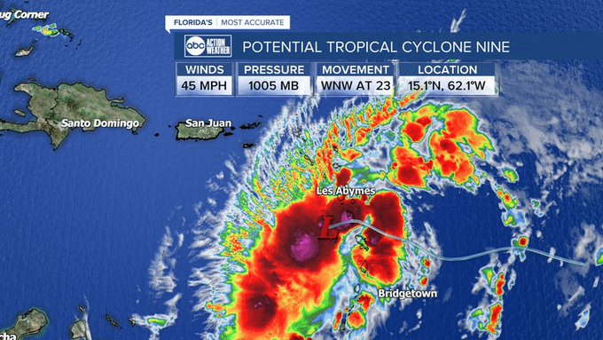
TD9 stayed well south of the former predicted tracking and is in the Eastern Cribbean Sea SE of Puerto Rico.
the Storm's Windfield extends almost 300 miles out to the North and NE of the Center.
All Puerto Rico and All DR will be in this powerful Windfield.
while this is not a Hurricane, it is a super Huge and very Powerful system and will be a Tropical Storm when making it's Landfall in the Dominican Republic later tonight/early Thursday morning, along our DR Southshores.
Interacting with PR first usually takes powers away from Storms, but this one will not make Landfall in PR and should not get bothered that much. PR will be completely in the N/NEern Windfield, but not touch the Center.
we have to be ready COUNTRY WIDE in the DR for over 70mphr Wind Force and torrential rainfalls for very long hours, minimum 10hrs long, but a Storm on landfall can slow down a lot, even get stationary for hours, so this could also last double that time.
do not rely on tracking forecasts for exact landfall location, this can change quick by many miles more East or West along our South Shores, once the system starts touching our high Mountain Ranges.
anyways, the full power winds and rains will most likely be felt/present Everywhere on DR Territory.
this is Not a small Tropical Storm like Jeanne back in 2004, this will be TS Isaias many times the size and powers of Jeanne.
Lock yourself in and stay inside until this all passed completely.
expect widely power outs and/or internet services down, flooded streets and do not expect businesses to be open tomorrow or friday.
Stay Safe Everyone.
 
  • Like
Reactions: Auryn

caribmike

Gold
Jul 9, 2009
6,808
202
63
Levi Cowan

@TropicalTidbits


Surface observations and satellite imagery indicate that #PTC9 is getting very close to having a closed circulation, even if it's still a broad one. Genesis of TS Isaias is likely not far off. Regardless of when this happens, tropical storm conditions likely in PR, USVI, and DR.
 

Dolores

Administrator
Staff member
Feb 20, 2019
18,555
2,914
93
NWS San Juan: Wind gusts of 40-60 mph are reported in Puerto Rico.
 

william webster

Rest In Peace WW
Jan 16, 2009
30,246
4,333
113
We hope - hope - that the north coast will get a reduced version of the winds
being on the other side of the cordillera, might reduce the speeds a bit

In Nagua/Cabrera/RSJ , the ridge is right behind us... very close
hopefully will blow over our heads somewhat

Be positive !!

SD & the southern shores... right on the chin, I'm afraid
 

GringoRubio

Bronze
Oct 15, 2015
1,162
116
63
We hope - hope - that the north coast will get a reduced version of the winds
being on the other side of the cordillera, might reduce the speeds a bit

In Nagua/Cabrera/RSJ , the ridge is right behind us... very close
hopefully will blow over our heads somewhat

Be positive !!

SD & the southern shores... right on the chin, I'm afraid

Keep in mind that the NW quadrant packs the biggest punch while the center is SE of, say, Puerto Plata, that wind and rain will be slamming into the mountains from the Atlantic.
 

Dolores

Administrator
Staff member
Feb 20, 2019
18,555
2,914
93
There is much uncertainty with the forecasts for Nine. I can't remember a storm of this kind so big so early in the Hurricane Season. For the DR hurricane season means September. The last hurricane that was in August, that I can remember was 30 August, Hurricane David, followed by Hurricane Frederick. From a statistical standpoint, storms in the Caribbean and this side of the world develop mostly in late August, September and October.

This is a record setting year for named storms so early in the year. We may run out of names.

Reading about this storm, what is leading to the uncertainties is that it is battling the Sahara Dust remnants and all the dry air. This is causing speculation that its center may be as down south as Barbados. The US Hunter planes have not yet found the center. And the storm is moving quickly 23mph. That is fast for storms. There have been many storms moving at a slow 5mph. A fast storm is much better than a slow storm. It causes less damage.

It is keeping south. Most tracks had shown it going much more to the north. The normal path for hurricanes this time of the year is to swerve north as they pass Puerto Rico.

Need to watch the pressure as an indicator of the threat of the storm. Let's see what the next weather forecasts bring.
 
  • Like
Reactions: Caonabo and aarhus

aarhus

Woke European
Jun 10, 2008
5,008
2,322
113
There is much uncertainty with the forecasts for Nine. I can't remember a storm of this kind so big so early in the Hurricane Season. For the DR hurricane season means September. The last hurricane that was in August, that I can remember was 30 August, Hurricane David, followed by Hurricane Frederick. From a statistical standpoint, storms in the Caribbean and this side of the world develop mostly in late August, September and October.

This is a record setting year for named storms so early in the year. We may run out of names.

Reading about this storm, what is leading to the uncertainties is that it is battling the Sahara Dust remnants and all the dry air. This is causing speculation that its center may be as down south as Barbados. The US Hunter planes have not yet found the center. And the storm is moving quickly 23mph - 37kmp. That is fast for storms. There have been many storms moving at a slow 5mph. A fast storm is much better than a slow storm. It causes less damage.

It is keeping south. Most tracks had shown it going much more to the north. The normal path for hurricanes this time of the year is to swerve north as they pass Puerto Rico.

Need to watch the pressure as an indicator of the threat of the storm. Let's see what the next weather forecasts bring.
It sounds like you could be the new weather and storm expert here.
 
Last edited by a moderator:
Status
Not open for further replies.