
Hard to believe a hurricane is coming. I hope none of the local fishmen get tricked into thinking this will be a miss.Live webcam from Kingston of the south coast. Nothing yet:
- Thread starter MikeFisher
- Start date
You are using an out of date browser. It may not display this or other websites correctly.
You should upgrade or use an alternative browser.
You should upgrade or use an alternative browser.
2024 Hurricane Season
- Status
- Not open for further replies.
I think he said this is Port Antonio, Jamaica. Live feed. It is starting to get intense there.

 www.tiktok.com
Cap_pone (@cap_pone) is LIVE | TikTok
Check out Cap_pone (@cap_pone) LIVE videos on TikTok! Watch, follow, and discover the latest content from Cap_pone (@cap_pone).
This is why stay away from waves, it can do good damage:

The govt. working night and day to clean it up.
These influencers like Jose need to dedicate a lot more time to issues with trash and the education of citizens.
Jose alone has over a half a million subscribers.
These influencers like Jose need to dedicate a lot more time to issues with trash and the education of citizens.
Jose alone has over a half a million subscribers.
I follow fundosami on igram. He's very environmentally conscious but doesn't have a lot of traffic. Wish he had more.The govt. working night and day to clean it up.
These influencers like Jose need to dedicate a lot more time to issues with trash and the education of citizens.
Jose alone has over a half a million subscribers.
Those guys are important in these cyber space times, to wake up people with time again and again and again.
No matter they have many or few followers, they all together count.
No matter they have many or few followers, they all together count.
I am surprised that all stayed quiet so far, aside of the lil Disturbance off the SE of the usa..
We have one strong Tropical Wave behind the other crossing from Africa over here,
but none got caught in any interaction with any Low Pressure System/Area to start some movement/development.
The Surface Conditions snippet is from 8:00PM last evening AST/DR-Time.
Conditions o the Highway out off our East are quiet favorable for stormy developments,
as there is actually zero wind shear out there(Over the Caribbean Sea, yes, we have high wind shear) and most of the Dry Air is located towards the N of the Prime Path.
Could warmer waters create high pressure zones that push tropical storms South this yearI am surprised that all stayed quiet so far, aside of the lil Disturbance off the SE of the usa..
We have one strong Tropical Wave behind the other crossing from Africa over here,
but none got caught in any interaction with any Low Pressure System/Area to start some movement/development.
The Surface Conditions snippet is from 8:00PM last evening AST/DR-Time.
Conditions o the Highway out off our East are quiet favorable for stormy developments,
as there is actually zero wind shear out there(Over the Caribbean Sea, yes, we have high wind shear) and most of the Dry Air is located towards the N of the Prime Path.
View attachment 9413
At this moemnt the Atlantic High is very strong and biiig,
it def forces storms of any kind on the southern lanes and does not allow to turn Northwards,
as we already saw with Beryl.
Without the strong wide High Pressure up North Beryl would have walked NWwards over some part of the greater Antilles instead of heading all the way W to Yucatan.
The Waters in the Tropical Atlantic, our Highway, from Wester Africa to the Caribbean, are very hot,
which allows storms fast intensifications and to reach highest power levels, even despite some dry air and over the medium range high wind shear,
also seen with beryl.
I am not sure if it helps your calculations, but I was at the beach this weekend in New Jersey specifically, Avalon and the water was very cold. It was about 68°.At this moemnt the Atlantic High is very strong and biiig,
it def forces storms of any kind on the southern lanes and does not allow to turn Northwards,
as we already saw with Beryl.
Without the strong wide High Pressure up North Beryl would have walked NWwards over some part of the greater Antilles instead of heading all the way W to Yucatan.
The Waters in the Tropical Atlantic, our Highway, from Wester Africa to the Caribbean, are very hot,
which allows storms fast intensifications and to reach highest power levels, even despite some dry air and over the medium range high wind shear,
also seen with beryl.
Water Temps at Beaches do not matter.I am not sure if it helps your calculations, but I was at the beach this weekend in New Jersey specifically, Avalon and the water was very cold. It was about 68°.
Storms build up and fuel on open waters far out, so the important temp factor is the Sea Surface Temperatures Out of our East and in addition the heat content/means how Deep high temps(26C+) do reach below the Sea Surface out there.
So far all quiet out there on the stormy front.
There is a baby-ow pressure area around the NW South American Continent, not associated with a Tropical Wave and no interaction with any disturbed weather there.
The next strong system, a wide area of Low Pressure, is closing in to hit Atlantic Waters off the West African Coast the next 24-48hrs.
Once over water for a couple days and caught up by the next Tropical Wave, we will see how big of an moistured low pressure area we will have over there on the other side of the Pond.
Next week?
 www.diariolibre.com
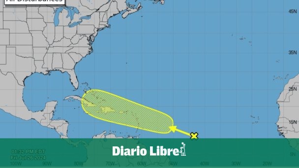
CNH alerta de posible desarrollo de disturbio tropical para la próxima semana
Aunque no se puede hablar aún de alguna proyección, el CNH marca un área amarilla que cubre a República Dominicana
www.diariolibre.com
It is an area of disturbed weather far out East.
To see what could come out of it, we have to wait until it will be caught up/mingles with an Tropical Wave still far behind it.
IF they come together and some development could start, would be after this coming weekend, more likely after mid next week.
The situation could change any day, but until such system is together it would be useless to speculate about it.
Hey, I will fly out for an other glorious 6 weeks with my ole folks this Sunday night, after we will have done our DR Fathers Day BBQ and one of my Grand Son's 4th BD celebration here on the lil Ranch.
But of course I will keep informed about any movements towards our soil or when I tell my Housedragon and the guys/gals to bring the cattle in.
So far we have nothing to fear anywhere around our homes.
Bon Voyage!It is an area of disturbed weather far out East.
To see what could come out of it, we have to wait until it will be caught up/mingles with an Tropical Wave still far behind it.
IF they come together and some development could start, would be after this coming weekend, more likely after mid next week.
The situation could change any day, but until such system is together it would be useless to speculate about it.
Hey, I will fly out for an other glorious 6 weeks with my ole folks this Sunday night, after we will have done our DR Fathers Day BBQ and one of my Grand Son's 4th BD celebration here on the lil Ranch.
But of course I will keep informed about any movements towards our soil or when I tell my Housedragon and the guys/gals to bring the cattle in.
So far we have nothing to fear anywhere around our homes.
Enjoy your summer in greener pastures..
Thank you for keeping us safe & in the loop from afar.
While so far no dangers of any kind are shown,
we have to watch the disturbed weather off the Windward Islands,
as it moves very quick forward/means IF it develops it would reach it's whatsoever Destin very quick/soon
and as the conditions in the Caribbean Sea are actually near perfect for stormy developments
with barely present wind shear, barely any dry air in the mid atmosphere and a hot Sea Surface.
Again, at this moment nothing is awaited/forecasted to develop to come our way/threaten our Island,
but it is a fast moving wave in company of heavy weather, so IF it decides to become something, then tings would go quick and warning time would be short.
Happy Sunday to everyone(mine is almost over, over here, lol).
- Status
- Not open for further replies.