hurricane season 2017

Status
Not open for further replies.

windeguy

Platinum
Jul 10, 2004
44,636
7,263
113
If things go as predicted at the moment: For Thursday afternoon there could be 30 to 50 knot winds for the Kite Beach Cabarete area, 6 plus meter surf and lots of rain. That is my best guess.

Along with that all of the power lines will melt and take weeks for Edenorte to repair them. :dead: (They are made of sugar, you know). :eek:gre:

CORAAPLATA will turn off the water because they take it from rivers and they will be full of debris and silt. :mad:

Nearly everyone in low lying areas facing flooding from heavy rains. New mattresses, ruined clothing, appliances, etc.

Those 6 meter waves can do some re-shaping of beaches and ocean front homes and businesses.

Hurricane force wind probabilities:

120644.png
 

MikeFisher

The Fisherman/Weather Mod
Feb 28, 2006
13,896
2,486
113
Punta Cana/DR
www.mikefisher.fun
no need forpanic, as nothing on the Path changed.
don't get tricked by slightly up and down moving predictions,
such storm is for most time not wandering a straight line, it runs zick zack like a drunk,
Irma is a maximum powered perfect Storm machine.
175mphr winds damage every kind of building, where ever those forces hit land.
all that counts and safe's us is the Path of the Storm.
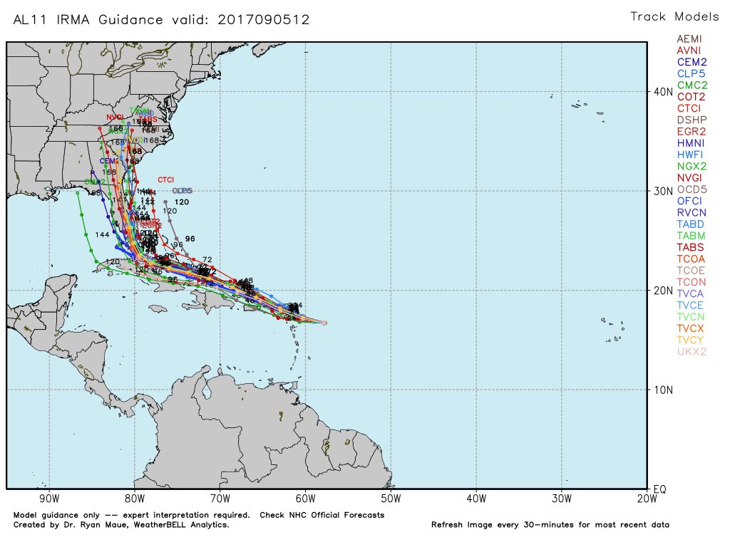
Irma is on 16.7N57.7W(by 8AM this mornin).
it is steaming on 14mph straight West, which been awaited and already calculated in all tracking forecasts of yesterday and last night. the tracking is on a slow turn, as you don't push such powerful machine around from one side to an other easily and specially not quick on such high forward speed. it should show more northward drift on the 2PM, hopefully for darn sure on the 5PM updates.
the Center of the Storm will wander somewhere 50-100 miles off the shoreline to our northcoast.
take that as much more than a close call.
someone mentioned above baby storms of 120mphr and that storm surge been no problem.
well, Irma is no baby storm and it's storm surge is a destructive power.
we are lucky that our natural tides are low actually, but don't thin that means nothing dangerous will roll ashore.
the NE'er Tip of PR is under highest danger, a short touchdown there is very likely.
get your stuff ready for tomorrow night, for here on the East our Wave Action will already be up during late afternoon.
on the North you should be under TS Force Winds for a very long time, such winds are powerful when moving/pondering structures for extended time frames/hrs on TS Strength.
the slightest change on Track could bring H-Force ashore.
we are close to touch down on the smaller Islands, from here we have to go in 3hrs steps and watch every update.
nothing is set in stone, not the powers, not the inishing of the turn, not the tracking.
the forecasts have been spot on with Irma so far, that give's nice confidence,
but Mother Nature is a Biach not to trust, like your Mothers in Law, just more biachi.
don't leave anything outside that could get loose and fly around, not for not loosing the thing, it is to not produce additional weapons flying around to hurt someone else or yourself.
our country's famous up-in-the-air electricity system will sure get many areas sent on vacay, so stock on gas and get used to Can Food, it's anyways healthier than all those Fat Burgers.

as for the southern part of the East Shores/Punta Cana,we are on the East/where the Beasts come from, but again it looks like we are the safe place.
we await Sea to not exceed 20ft, but thats something to look on when it rolls in.
it could really stay down that much due the counterclock wise rotation, we usually get the highest surf from Storms passin the South of the Island.
we expect winds forces just between 30-40Knots. if that's what will ariive, then we can handle that safely and some areas cut off the power grids will be the big inconvenience for some days, aside of heavy floodings of well known sections plus some new flooding areas to be shown for sure.
The Whole Island will sure as Heck get wet like never before.
here you see the heavy waterloads carried by Irma, compared to the size of the Islands.

I have all the time our friend jstarebel in mind,
he will have a heck of a ride of a life time and hopefully we will read him back here soon.

follwo all updates every 3hrs and be ready to shut all your stuff down tomorrow afternoon for 24hrs.

Mike

wv-animated.gif
 

MikeFisher

The Fisherman/Weather Mod
Feb 28, 2006
13,896
2,486
113
Punta Cana/DR
www.mikefisher.fun
I don't understand how these models keep projecting a dramatic turn from Cuba into FL, when it appears the hurricane is making a straight link into the Gulf.

such turn is not set, yet.
it depends on too many variables of shifting/changing things.
once it passed the DR and wanders somewhere South of the Bahamas/North of Cuba, the Tracking will get clearer.
by now the tracking afte touching the greater Antilles is highly uncertain.
heck, the track leaves all possibilities open every time such Storm touches Land, like it will do very soon over te Leewards.

Mike
 

cobraboy

Pro-Bono Demolition Hobbyist
Jul 24, 2004
40,975
945
113
This storm is a great example how the friction of the storm against the mountains of the DR can keep it more offshore of us.

Just be thankful that Irma is north of the DR and not south. The NNE side of storms get the worst of it all.

It remains to be seen how the Antilles deflect the direction of Irma.
 

MikeFisher

The Fisherman/Weather Mod
Feb 28, 2006
13,896
2,486
113
Punta Cana/DR
www.mikefisher.fun
just for completion of our 2017 Storm Outlook for NOW:
the Disturbance in the SE'ern Wake of Irma shoudl be a Tropical Storm within the next 48hrs.
i have no clue about the tracking or such, don't check it at this time,
but they always seem to get atracted by the prepared pavement of a just passed system,
so it should finally come to hang around the NE of the Islands soon.
IF it develops strong, we can watch that onceClaro gives us our internet back.

Mike
 

bigbird

Gold
May 1, 2005
7,375
164
0
because yours shows the probabilities of receiveing Tropical Storm Force winds only.
windeguy's one shows the probabilities of receivin HURICANE Force winds.

Mike

hahaha, thanks Mike. I guess I need to improve my reading skills. LOL

What is the difference between Tropical Storm Force winds and Hurricane Force winds? I am under the impression the speed of the wind determines if it is categorized as Tropical or Hurricane.
 

MikeFisher

The Fisherman/Weather Mod
Feb 28, 2006
13,896
2,486
113
Punta Cana/DR
www.mikefisher.fun
This storm is a great example how the friction of the storm against the mountains of the DR can keep it more offshore of us.

Just be thankful that Irma is north of the DR and not south. The NNE side of storms get the worst of it all.

It remains to be seen how the Antilles deflect the direction of Irma.

you got that exactly right.
the strongets windsforce to feel is the right side eyewl of a counterclockwise rotating Storm.
that makes for a Storm wandering S of the Island from E-W the N-side(towards the Island) the most powerful part.
yes, directions can and often does get influenced when touchin land, hence we have to watch every available update for changes. from now til tomorrow night will be a very long time for some i guess.
time for a ride to the super, runnin out of smokes. later i get my big delivery, just in case my lil colmaditos around would not stay dry.

Mike
 

MikeFisher

The Fisherman/Weather Mod
Feb 28, 2006
13,896
2,486
113
Punta Cana/DR
www.mikefisher.fun
hahaha, thanks Mike. I guess I need to improve my reading skills. LOL

What is the difference between Tropical Storm Force winds and Hurricane Force winds? I am under the impression the speed of the wind determines if it is categorized as Tropical or Hurricane.

yes, it is the powers that give the name.
winds from 34-63Knots are named a Tropical Storm.
from 64Knots/74mphr ahead a Storm is named a Hurricane.

Mike
 

cobraboy

Pro-Bono Demolition Hobbyist
Jul 24, 2004
40,975
945
113
Does anyone know if the dams are being emptied right now?
 

bigbird

Gold
May 1, 2005
7,375
164
0
hahaha, thanks Mike. I guess I need to improve my reading skills. LOL

What is the difference between Tropical Storm Force winds and Hurricane Force winds? I am under the impression the speed of the wind determines if it is categorized as Tropical or Hurricane.

A little research and I will answer my own question. If the wind speed averages for one minute between 39mph and 74mph the storm is classified as a Tropical Storm. If the wind speed averages for one minute above 74 mph it is considered a Hurricane. (think I am right)

Why do the categories begin at 74 mph instead of 39 mph or some other incremental wind speed? The current scale, the Saffir Simpson Hurricane Wind Scale (SSHWS), is an extension of an old British Navy scale called the Beaufort Wind Scale. 

The Beaufort scale broke up winds into 12 forces or grades from calm winds up through gale force winds to hurricane strength winds. The 12th grade on the Beaufort scale is "hurricane," a grade defined by winds of 64 knots or 74 mph at its minimum bound and no maximum bound. 

The SSHWS breaks up that hurricane grade into five categories. The tropical storm category is a grouping of some of the Beaufort grades. 
 

dv8

Gold
Sep 27, 2006
31,262
364
0
from what i have seen so far the dams do not get emptied in advance. the last few times the floodgates were open when the water reached dangerous level. i did a quick search and there is no info about any activity regarding dams atm.
 

windeguy

Platinum
Jul 10, 2004
44,636
7,263
113
Hurricane force winds for the North Coast

120644_5day_cone_with_line_and_wind.png


Hurricane force winds are now predicted in the watch for the north coast. IRMA is big.

What will 6 meter or more waves do to the Malecon in POP, or Cabarete Beach?
 

MikeFisher

The Fisherman/Weather Mod
Feb 28, 2006
13,896
2,486
113
Punta Cana/DR
www.mikefisher.fun
A little research and I will answer my own question. If the wind speed averages for one minute between 39mph and 74mph the storm is classified as a Tropical Storm. If the wind speed averages for one minute above 74 mph it is considered a Hurricane. (think I am right)

Why do the categories begin at 74 mph instead of 39 mph or some other incremental wind speed? The current scale, the Saffir Simpson Hurricane Wind Scale (SSHWS), is an extension of an old British Navy scale called the Beaufort Wind Scale. 

The Beaufort scale broke up winds into 12 forces or grades from calm winds up through gale force winds to hurricane strength winds. The 12th grade on the Beaufort scale is "hurricane," a grade defined by winds of 64 knots or 74 mph at its minimum bound and no maximum bound. 

The SSHWS breaks up that hurricane grade into five categories. The tropical storm category is a grouping of some of the Beaufort grades. 

it is the scale that became the most used one.
it's been modified often and not very old on the actual version, the actual one is in place since 2012 i think.
and todays it solely reflects the windspeed.
the categories do not reflect/include anymore the destructiove potential, storm surge etc etc factors of a Storm, it is solely the windspeed.
we had Tropical Storms(remember Sandy) that had more destruction powers(in case of Sandy due the wide Storm Surge running in also on highest tiedes of the year) than many Major Hurricanes have.
the working forces of a Storm are measured on other scales, not the windscale/not the Category.
btw, it is only the americans(and we use the same in the DR) who estimate the maximum sustained winds by the average winds measured for 1 minute. the European smeasure those by the average of a 10 minutes cycle.
many small differences within the different measurements and scales on the different continent,
they are all very similar on the number orpotential they show under the line as the sum.
we do not need it that exact to know whatis coming.
something named a Storm is def something incomfy and certain things should be prepared for it.
if it's named a Hurricane a full set of preparations should be in place.
if it is named a Major Hurricane, the religious guys should start up their best prayors
andthe rest should get Town prepared and bring da cattle away to safer pastures.

Mike
 

MikeFisher

The Fisherman/Weather Mod
Feb 28, 2006
13,896
2,486
113
Punta Cana/DR
www.mikefisher.fun
120644_5day_cone_with_line_and_wind.png


Hurricane force winds are now predicted for the north coast. IRMA is big.

What will 6 meter or more waves do to the Malecon in POP, or Cabarete Beach?

such things are hard to predict.
how fast do they come in, what's the wave frequency etc etc are factors.
in general 20ft'ers are not anything of any concern out on Sea,
but bouncing on certain shoreline formations for a lengthy time frame will take a huge load of land away.
read the real time happening report from Puerto Rico once the Surge arrives there.
Irma will be farer away from DR Northsores than from PR Shores,
so expecting to receive what PR gets will keep your calculation on the "safe" side.
I remember early times here, i thin it was named Hortencia, but no mood or time to research that now,
when i was in El Cortecito in Bavaro.
for the ones who are in the area, as i know some on this bord are:
the waves run in El Cortecito, where Capitan Cook Restaurant is(exactly there was my fishing place at that time), up to the Street of El Cortecito between the buildings there.
and that was a Time when the Beach in El Cortecito been at least 3-4 times the size/deep than it is now.
todays the beach shops/buildings are on natural high tides right at the water line, there was a very nice deep beach front back in teh day, between those buildings and the waterline.

Mike
 

windeguy

Platinum
Jul 10, 2004
44,636
7,263
113
If you like to be a bit confused here are all the recent models and their tracks for this currently Category 5 Hurricane IRMA:

DI9nsFRV4AAjIL_.jpg:large
 

DR Solar

Bronze
Nov 21, 2016
1,626
365
83
You're doing great Mr. Fisher. Thank you!

Has the pressure been changing this morning?

All the birds are gone now. Noticed early that very few around and now none and thought that birds are sensitive to those changes.

I also am clearing my ears more. I have a small ear canals that diving 30' took a long time and would be painful if I could not balance my ears. I stopped diving. Flying is not as bad but constantly clearing my ears to equalize pressure.

Thanks.
 
Status
Not open for further replies.