2020 Hurricane Season

Status
Not open for further replies.

MikeFisher

The Fisherman/Weather Mod
Feb 28, 2006
13,771
2,206
113
Punta Cana/DR
www.mikefisher.fun
so w's up for this week?
NHC raised the bar to 60% chances that the Invest becomes a Storm.
the simple reality:
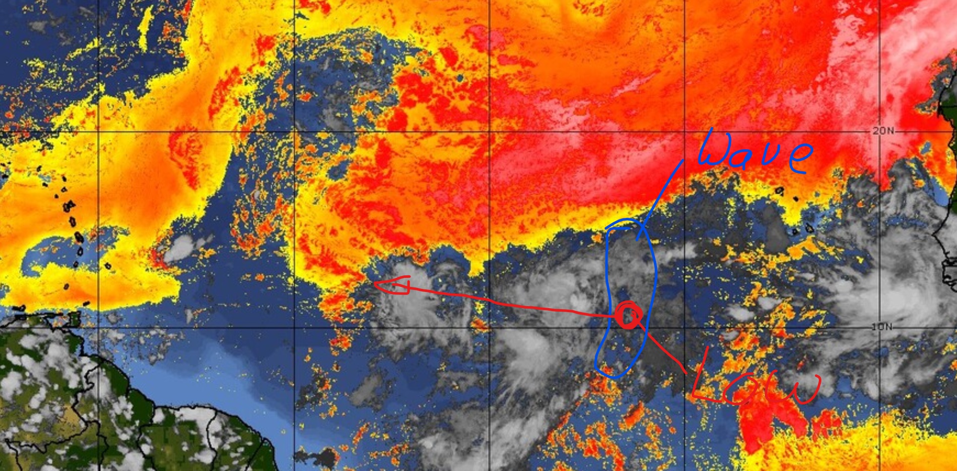
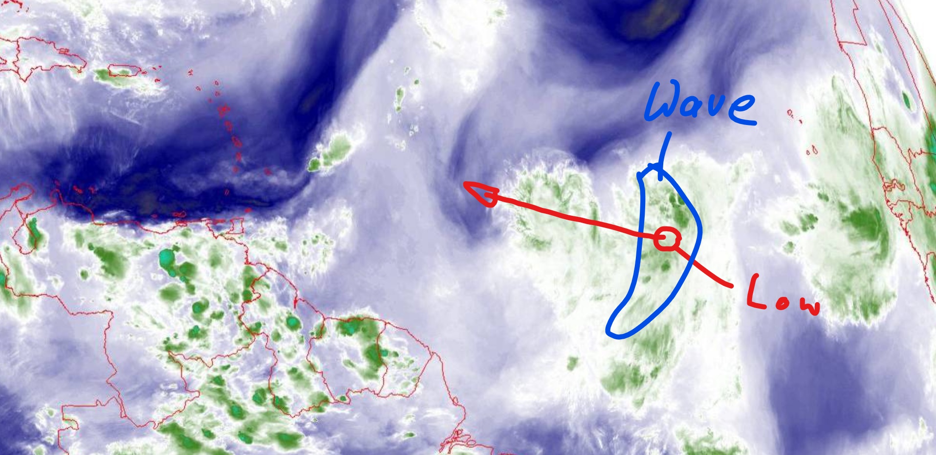
nothing changed since the system is up and moves on a good 10mphrs W, traveling with a elongated normal Tropical Wave.
the Surface Low did not organice anything, shows no circilation and contains no heavy thunderstorm areas.
sure winds in the center of the Low could reach windspeeds, that would determine it as a TD,
it could do so tomorrow, it could already have had such winds today, but such does not make a Storm in the make to become a Cyclone.
we have out there a Surface Low brought by a Tropical Wave E to W, walking WWNW to be precise.
as usual, thatTropical Wave is a elongated area from N to S, moving Westward.
it carries the Low in it's middle and that Low show's to this moment no circulation nor heavy thunderstorm areas,
so we have no indicators given that would let us await anything big in the make.


a TD could form tomorrow or by Wednesday,
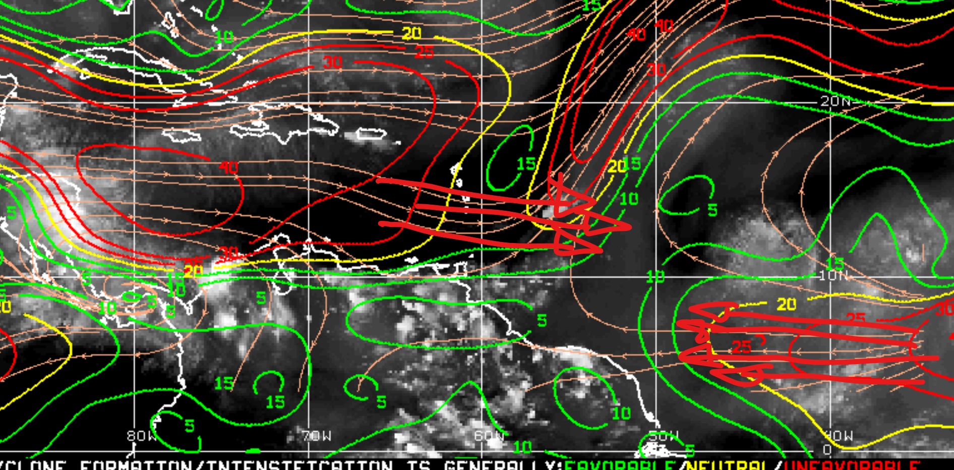
BUT on the Wave's S the mid level winds are blowing E to W, a windshear counterproductive to a forming storm's counterclockwise circulation.
to it's NW the whole formation is running into a nice layer of dry saharan air, an other piece that slows/bothers formation.
and then, closer to the Windward Islands, we have such mid level winds blowing 30Knots W to East where then the Wave's/Storm's Northside of such counterclockwise rotating center would be.

I can't magically predict all involved factors for almost a week in advance on a 1500 miles long journey,
but the actual conditions and the outlook on their "movement/changes" at This Moment,
do tell me that we will not see anything big, not even anything with a name out of this one.
a TD the next couple days would be the maximum power i would see.

we keep watching, these curfew days we anyways have nothing better to do in the evenings,
but by now we have no danger out there for our Isle.

ADDY:
to a shit internet connection here my shown outlook and screenshots are from this afternoon 3/4PM.
2020-08-10_LI.jpg


2020-08-10 (1)_LI.jpg


2020-08-10 (2)_LI.jpg
 

Linda Stapleton

Well-known member
Jun 3, 2003
633
45
48
Thanks for being back with us, Mike, and keeping us updated. Here is another update here, the part relevant to us starts 6 minutes in:
 

MikeFisher

The Fisherman/Weather Mod
Feb 28, 2006
13,771
2,206
113
Punta Cana/DR
www.mikefisher.fun
today a Center of circulation is clearly visible, so this is what we define as a Tropical Depression, a Storm.
it sure will be declared a TD by the NHC today.
the elongated form of a typical tropical wave is gone, we now have a real Invest, a area of disturbed weather forming into a storm.
by now, on it's very early stage, all moisture and it's weak thunderstorm activity is located on it's NW and W Quadrants.
the system's job is to form that as one round "equaly proportioned" area around the center.
the Center's location is on around 11.5 degrees N, so circulation/swing are given.

BUT, so far nothing to worry about, because:
it will soon start to run into dry saharn air on it's N and W, slowing down development.
around late Thursday/Friday it will pass the 50thW, from there on bothered by Windshear blowing into it's NW Quadrant.

the most likey near future of the system:
it will be declared a TD today.
it will get into a better shape/form, which could allow to be named as a TS Wednesday/Thursday, but not very likely due the dry air presence.
which ever level it will reach the next couple days, by later Thursday/Friday ahead Windshear will give it a knock and hinders a further growing up.
Tracking of the system should stay on WWNW and closer to the Antilles(around 1000 miles out off the E) change more northwards tracking then WNW or NW,
to point towards the Leeward Islands.
a further ahead of time outlook is too much speculation, my best guess would bring it to or missing slightly out NE the northern Leeward Islands.
this long range tracking can change a lot depending how good it get's together as a storm before closing in, so this is only the long range tracking outlook for Now/this moment.

so far we have nothing to worry about, we are in watch mode.


2020-08-11_LI.jpg
 
  • Like
Reactions: HDR

MikeFisher

The Fisherman/Weather Mod
Feb 28, 2006
13,771
2,206
113
Punta Cana/DR
www.mikefisher.fun
one point I forgot to add in my above post:
the reason for all the thunderstorm activity(which is still light, nothing powerful) to be on the N and W of the Center,
is the yesterday mentioned Windshear to it's South blowing E to W,
blowing Against the direction of the "Storm's" winds on it's SW, S and SE Quadrants.
 

jstarebel

Silver
Oct 4, 2013
3,330
333
83
today a Center of circulation is clearly visible, so this is what we define as a Tropical Depression, a Storm.
it sure will be declared a TD by the NHC today.
the elongated form of a typical tropical wave is gone, we now have a real Invest, a area of disturbed weather forming into a storm.
by now, on it's very early stage, all moisture and it's weak thunderstorm activity is located on it's NW and W Quadrants.
the system's job is to form that as one round "equaly proportioned" area around the center.
the Center's location is on around 11.5 degrees N, so circulation/swing are given.

BUT, so far nothing to worry about, because:
it will soon start to run into dry saharn air on it's N and W, slowing down development.
around late Thursday/Friday it will pass the 50thW, from there on bothered by Windshear blowing into it's NW Quadrant.

the most likey near future of the system:
it will be declared a TD today.
it will get into a better shape/form, which could allow to be named as a TS Wednesday/Thursday, but not very likely due the dry air presence.
which ever level it will reach the next couple days, by later Thursday/Friday ahead Windshear will give it a knock and hinders a further growing up.
Tracking of the system should stay on WWNW and closer to the Antilles(around 1000 miles out off the E) change more northwards tracking then WNW or NW,
to point towards the Leeward Islands.
a further ahead of time outlook is too much speculation, my best guess would bring it to or missing slightly out NE the northern Leeward Islands.
this long range tracking can change a lot depending how good it get's together as a storm before closing in, so this is only the long range tracking outlook for Now/this moment.

so far we have nothing to worry about, we are in watch mode.


View attachment 3116
Thanks for your forecast Cap.. I learn a lot from your explanations and find your commentary very interesting.. On another note, do you ever fish the Cap Cana Tournaments??
 
  • Like
Reactions: MikeFisher

MikeFisher

The Fisherman/Weather Mod
Feb 28, 2006
13,771
2,206
113
Punta Cana/DR
www.mikefisher.fun
the transition and strugging process's already set in, when comparing early morning look to the actual look,

so to me there is a clear Trend:
the strongest Thunderstorm piece is located on the NW Quadrant and closest to the Center/right attached to the center and a broader Thunderstorm activity area in the N Quadrant reching out further from the center.
this will produce sufficient windspeed to be named a TD.
the S and SE Quadrants leak of any strong Thunderstorm activity, a clear sign that the mentioned counterproductive E-W winds south of the storm do their job.
before sunset today we will see that the S and SE of the storm will be clear of any Thunderstorm activity.
due the dry air on it's NW, the strong Thunderstorm activity on it's NW will be strongest but limited to an small area right near the Center.
the N Quadrant will be the wide "strong" area of a then Tropical Depression.
the whole S and SE will be dead land for a storm.

I don't see any dangerous system brewing out there.
 
  • Like
Reactions: hormiga1970

DR Solar

Bronze
Nov 21, 2016
1,626
365
83
  • Like
Reactions: Caonabo

MikeFisher

The Fisherman/Weather Mod
Feb 28, 2006
13,771
2,206
113
Punta Cana/DR
www.mikefisher.fun
agreed with ONAMET's local outlook, I do myself not predict such local and by areas different trends.
in case of their Storm Outlook, on systmes this far out ONAMET is doing Zero predictions, they always solely read the NHC outlook and translate it in their words and into spanish.
 

MikeFisher

The Fisherman/Weather Mod
Feb 28, 2006
13,771
2,206
113
Punta Cana/DR
www.mikefisher.fun
yes, TD11 is born and has a fixed center on 11.7N/40W,
so my awaiting of a Cneter to be on at 11.5N was nicely close.
I have the stor fixed and will take it's tracking late this evening,
as you always need as many hours as possible to pass by to get the real deal direction.
as far as powers and formation go, it looks as expected, with the strongest on the NW right at the center and the biggest area to be the N Quadrant reaching out farest from the Center. no real powers so far, as this developing construction get's the Sern parts cut off and dry air from the NW.
we will se how it evolve's til late evening and then what it looks like tomorrow noon.
it is shown on NHC as a straight West runner on high 14Knots foward speed.
no doubt on the forward speed,that's why it was an hour ago already on the 40thW,
but noway is it running straight Westward, steering winds say different and forming Thunderstorm areas around the Center, at least trying to do so, will make the center jump WNWwards and bring the over all tracking to WNW.
at least that's what I await of it's tracking.
I stick to my early take, that this one will not do any harm to us.
 

MikeFisher

The Fisherman/Weather Mod
Feb 28, 2006
13,771
2,206
113
Punta Cana/DR
www.mikefisher.fun
TD11 already passed the 12thN, means tracking is the awaited WNW and turning,
so during tomorrow it should be on a NW Course, which will let the storm miss the Leeward Islands on their NE.
chances to become a Tropical Storm are given, but nothing bigger, given running into the dry air and closer to the Antilles into windshear, too.
Important for us is the Tracking, as this TD11 or future Josefine will not come cose to us.
by late sunday/sunday night it will be placed far out North of Puerto Rico.
 
  • Like
Reactions: NanSanPedro

MikeFisher

The Fisherman/Weather Mod
Feb 28, 2006
13,771
2,206
113
Punta Cana/DR
www.mikefisher.fun
no changes on TD11 today so far.
Thunderstorm areas are limited to small areas now on it's N and NE.
no winds extending out from the Center in any direction.
the strongest thunderstorm areas are far from reaching lowest TS Force.
the center is nice set and circulation is clear and clean,
but the E-W strong winds on the S keep away any development on that side of the storm, the S and SE are almost cloud free.
the NW carries some moisture but getting dried due a good amount of saharan air there on it's way.
this storm will have a very hard time to reach the status of a weak TS/to get a name for the Stats.
Tracking is today a constant WNWwards, pointing to a track to miss the Leewards on their NE.
so far it goes as expected.
No danger in sight for our Island.

2020-08-12_LI (2).jpg
 

MikeFisher

The Fisherman/Weather Mod
Feb 28, 2006
13,771
2,206
113
Punta Cana/DR
www.mikefisher.fun
when the night comes, ...
it was a bit hard to get a good shot on TD11 this evening, because it does not bring up much reflections , it is a shy one.
the S of this storm is not existing, no real Thunderstorm areas to spot anywhere nearit's center this evening.
the shown shot is already from around 10 or 10:30PM this evening.
there is no change on Tracking, it moves around 15mphrs WNWwards and will miss the Islands on their NE.
as the surface low is such a small center now, pressure by satellite is hard to estimate.
the NHC show's it on the very same 1007mb, no change, no gaining powers, no development of anything.
it is running in completely dry air and has more of that on it's path.
the main reason for no development at all, is the E-W blowing winds on it's South, so it never managed to get into any shape..

nothing to worry about out there for this week


2020-08-12 (2)_LI.jpg
 

Cdn_Gringo

Gold
Apr 29, 2014
8,672
1,133
113
Hopefully it will pass us by with enough distance that we don't know it's even there. A small amount of rainfall and a very light breeze is about all I hope this soon to be TS will to deliver to my house. I won't be disappointed if it delivers nothing though.
 

MikeFisher

The Fisherman/Weather Mod
Feb 28, 2006
13,771
2,206
113
Punta Cana/DR
www.mikefisher.fun
we will not get anything from TS Josephine.
I am on a Tour til later afternoon today and will take a closer look and report this evening.
We are NOT in any danger, what ever Josephine would be named, this system has no chance to visit my backyard.
Hey,
it is a hot sunny day in paradise and still some hours til curfew.
don't panic, ENJOY!!!!
 
  • Like
Reactions: Michael DR
Status
Not open for further replies.