hurricane season 2017

Status
Not open for further replies.

MikeFisher

The Fisherman/Weather Mod
Feb 28, 2006
13,896
2,486
113
Punta Cana/DR
www.mikefisher.fun
The storm weakened after hitting landfall.

Tampa did fine, as did most of the west coast of FL. Trees & signs down, some onto structures and cars (like Alida's sister in Miami Lakes), aluminum parking shelters down.

Flooding was no where near what was predicted.

Power still out in many areas, but looks like they did fine.

I've not heard from my property manager. My concern is a huge, old camphor tree on the property.

FL was well prepared.

good to hear.
been in touch with my friends who have their property in Clearwater.
family of them checked the place and all is fine.
they been told that Irma took a more estern touch before reaching up there so they did not get anything over heavy.
the are glad that they spent the weekend in Massachusetts and will leave to stay safe any time again.

Mike
 

Drperson

Well-known member
Sep 19, 2008
1,114
319
83
What are cb homes

I've been to many islands here in the Caribbean. In general, the concrete block houses are built very well. Many have concrete roofs which is a plus. Wood frame houses don't fare so well, mostly becuase they don't require roof straps in their building codes - same with CB homes with wood truss roofs.

A general lack of hurricne shutters anywhere here in the Caribbean doesn't help. The media just shows too many pictures of poorly constructed houses in the barrios after a hurricane.

When Andrew hit Miami with 165 mph winds, there wasn't much left standing where the eye wall went through , including well constructed CB homes.
 

Drperson

Well-known member
Sep 19, 2008
1,114
319
83
Ok cb. Is cement block.
What are the roof straps you mentioned


I've been to many islands here in the Caribbean. In general, the concrete block houses are built very well. Many have concrete roofs which is a plus. Wood frame houses don't fare so well, mostly becuase they don't require roof straps in their building codes - same with CB homes with wood truss roofs.

A general lack of hurricne shutters anywhere here in the Caribbean doesn't help. The media just shows too many pictures of poorly constructed houses in the barrios after a hurricane.

When Andrew hit Miami with 165 mph winds, there wasn't much left standing where the eye wall went through , including well constructed CB homes.
 

Catseye

Member
Nov 7, 2009
163
1
18
Rio San Juan, Dominican Republic
to answer your question what are roof straps?


 my house in Fort Myers Beach had hurricane straps, they were strips of metal that were bolted to the roof and
then bolted to the walls all the way around every couple of feet or so, my roof guy showed them to me once, said they were great to have to help the roof not blow off in a hurricane
 

cavok

Silver
Jun 16, 2014
11,250
5,167
113
Cabarete
to answer your question what are roof straps?


 my house in Fort Myers Beach had hurricane straps, they were strips of metal that were bolted to the roof and
then bolted to the walls all the way around every couple of feet or so, my roof guy showed them to me once, said they were great to have to help the roof not blow off in a hurricane

That's correct. Not only are they great, but I am sure you know, they are required by Florida building code. Roofs are not only just blown off by the wind. When there is a break in a window on the windward side of the house during a hurricane(one of the main reasons for hurricane shutters), the increase in pressure inside the home will literally blow the roof off the house, or at least lift it up to where the wind can catch it. That's why roof straps have been required per code since Hurricane Andrew.
 

MikeFisher

The Fisherman/Weather Mod
Feb 28, 2006
13,896
2,486
113
Punta Cana/DR
www.mikefisher.fun
Sanwiched Jose is still a Cat2 Cyclone running about 100mphr winds.
sure as he.ll it avoids the Irma conditions on it's West, the same time it already bounced from/came too close to a over 1020mb Wall on it's North, hence Jose is already Turning.
it's actual Heading is 360 degrees, straigt north.
tonight that Turn will continue, buy tomorrow Noon it should be already wandering the for a Hurricane weird Est Heading
and continue during the day the Turn to wander into the rarest of all directions, Heading SE.
that clockwise turn will continue til Jose did a Turn of about a full 360 Degrees, from it's formerly NW Heading a right turn til again a NW Heading.
conditions do not indicate that the Storm would intensify during that whole weird move,
but it can easily hold still Hurricane Powers when again heading NW'wards along the Bahamas but several hundred miles North out on Sea, towards the Carolinas.
the Atlantic High Ridge will be positined very different then, the models expect it to be gone/way back/weak, as they are in agreement about the NW Heading again after mid week.
it may become "No Way Jose" for the books, as it know's No Way where to go.

here you see the HigH Pressure Barriers taking Jose hostage as a Sandwich fillet:
tgsfc1.gif


as a Storm Jose is not in very good shape,
such weird Moves/Turns are against such Cyclones Nature when wandering North of the Equator,
but still producing Cat2 powers tonight it could still be on lower Hurricane Forces by Thursday afternoon
and get it's Core organized again once back on the used to NW Heading.
wv-animated.gif


we will see what the present conditions for intensification and Heading will be for after Mid Week.
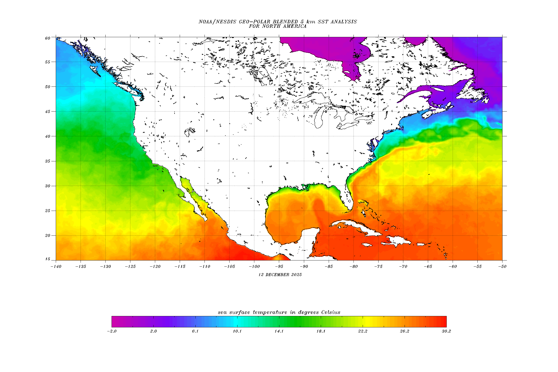
Sea Surface Temps are not in the Hostile Range to cool down a Storm,
but they are far from Hot Waters to fuel a recovering Storm quickly.
so many days ahead of time I would say it will not really recover, nothing quick and nothing strong,
getting steered out back over open water for the last time then way off the US Central East Shores,
bring it further North on the Map over real cooler waters to take all fuels away and let it die there
Tuesday/Wednesday next week somewhere between North Carolina and Bermuda,
without coming into vicinity of any Landmass ever.

to see this map do a "right mouse click" and choose the option "open image in a new window".
I don't know why, but many of the weather images show on DR1 this weird and can only be seen on their full scale when opening them in a new window.
namerica.cf.gif


Disturbance1, West of the Cape Verde's,
will not develop into anything, conditions did not build up.
it will be up north at the graveyard well before reaching the half way point of the Highway.
an significant effect of this Disturbance is that it su.cked up all the nice dry air shied over the Highway.
but we have already a new Shield up on the farest East, right off the African Westcoast,
so what ever activity will be tried by the next Disturbed Weather Area, which will leave Africa tonight to hit Atlantic Waters, it will be low key activity running into a dry air barrier right from the start.

Mike
 
Last edited:

Natu

Member
Jan 20, 2013
283
8
18
A tropical wave located in the caribbean sea might start affecting our weather conditions in the weekend.. Rain season is not over yet!!
 

MikeFisher

The Fisherman/Weather Mod
Feb 28, 2006
13,896
2,486
113
Punta Cana/DR
www.mikefisher.fun
A tropical wave located in the caribbean sea might start affecting our weather conditions in the weekend.. Rain season is not over yet!!

so far no Tropical Wave to spot anywhere in the Caribbean Sea,
not even any Disturbed Weather Area to mingle with such wave in the C-Sea.
btw,
the Hurricane Season is for this Island NOT a rainy Season, over all our summers are dry, all droughts that happen to this country happen during late Spring and Summer.
the DR receives it's life saving rainfalls during Fall and Winter, exactly when there is no Hurricane Season.

Mike
 

Natu

Member
Jan 20, 2013
283
8
18
so far no Tropical Wave to spot anywhere in the Caribbean Sea,
not even any Disturbed Weather Area to mingle with such wave in the C-Sea.
btw,
the Hurricane Season is for this Island NOT a rainy Season, over all our summers are dry, all droughts that happen to this country happen during late Spring and Summer.
the DR receives it's life saving rainfalls during Fall and Winter, exactly when there is no Hurricane Season.

Mike

Oh ok... Thanks for the clarification.

I got that information (or misinformation) from what the meteorologist was saying in Roberto Cavada's tv show and according to the graphic they showed, there was an area of thunderstorms in the south caribbean sea, close to Trinidad and Tobago, and they were saying that the system, in combination with local daytime heating cycle, would probably cause some rain and thunderstorms for the weekend.

But i was checking the loop, and it looks like the thunderstorm clouds dissapeared from thin air.

http://www.ssd.noaa.gov/goes/east/tatl/rb-animated.gif
 

XTraveller

Well-known member
Aug 21, 2010
669
318
63
Thank you Mikefisher, I am living in easterner south shore and had minor effect of irma as you have predicated. I am long-time member of DR1 but do not participate in all the threads.
I appreciate your value and educated opinion on these storms because you can explain in laymen terms all the “professionals’ options”.
You are the best meteorologist in DR and without you we will be with “nada” here.
I hope that all DR1 members can appreciate your contributions. I for one if ever in you region will pay for “green ones”, I personally prefer the brown ones Bohemia

XTraveller
 

caribmike

Gold
Jul 9, 2009
6,808
202
63
Jose looks almost like being on stand by waiting to hit the US after Irma is done now... Hopefully not.
 

MikeFisher

The Fisherman/Weather Mod
Feb 28, 2006
13,896
2,486
113
Punta Cana/DR
www.mikefisher.fun
Jose looks almost like being on stand by waiting to hit the US after Irma is done now... Hopefully not.

naaaa,
Jose is wandering as I described last evening.
I did not take any closer look on the weather today, yet, sleeping again til 9:30AM after the Girl been ready for school at 6AM been great, lol.
Jose is inthe middle of it's full 360 Degrees Turn, loosing forwards speed and loosing Windpowers.
it's heading this mid morning should be Eastwards, yeah weird, but this one is that weird,
then it will be SE, S, SW, W and finally back to the prior NW.
it will not pick up much strength once back over less cool waters further South of the actually cool water region.
it should turn again waaay before reaching the USA, the typical Turn for weak Storms moving that way to their,
out to Sea to find it's grave then.
Circle Around Jose will not threathen anybody anywhere.

at the Moment we have nothing to watch anywhere out there, time for a lil weather rest.
It anyways been already enough action for one Season I say.
the weather gys can get more experience on their outlook next season.
Mike
 

MikeFisher

The Fisherman/Weather Mod
Feb 28, 2006
13,896
2,486
113
Punta Cana/DR
www.mikefisher.fun
almst stationary Jose is stil drifting towards SE, too weak to go against any high pressure line on it's northern surroundings,
chumming colder waters from beneath the Ocean's warmer surface waters.
it is not a very healthy formation, a Hurricane on the low Cat1 scale.
steering currents are already up to bring it back on the usual NW'ern Heading,
I guess in the morning we will see it wandering towards the West, during the day then further turning til NW'wards will be on the compass. speeding up a bit later then on forward speed and running the typical Near-US-Shore Track NE over open deep cold waters between the mainland and Bermuda towards it's final Destination: Nowhere.

the actual weak waves ove rthe Atlantic are not associated with any areas of disturbed weather,
so for several days out we should not get anything new on the Highway Radar.

also the Caribbean Sea does not show any strong tropical wave activity and should be good to be safe for days out of now.

again on Jose:
in case it would not catch up with the esterlies by tomorrow morning and continue drifting towards the S/SE,
coming within a around a 600 and less miles of ditance it would start to bring significant wave action and on nearer approach alos clouds/rain over the Virgin Islands, mainly Puerto Rico and the DR-Northshores. waves would also come down to effect PC Shores north of the Cape, in Bavaro and Uvero Alto then.
but i am confident that the Easterlies will show their powers and move that ole piece of something definitaly out of our vicinity.
Jose is running around our grounds much too long by now, time to come to an end.

Mike
 

MikeFisher

The Fisherman/Weather Mod
Feb 28, 2006
13,896
2,486
113
Punta Cana/DR
www.mikefisher.fun
i guess most stuff is more fun as a "couple", hehe.
Jose turned away on time and will not come back this time.
Disturbance 2 has a bad paved highway ahead, even if it becomes a TD it should not last long as a Storm.
Disturbance 1 does not look as bad, butt is too young for a outlook.
we have a look again over the weekend.
nothing bad anywhere taht could reach us the enxt days, so no reason to worry about anyything else than not to be ready on time with teh BBQ, not well stocked on cold green medicines or to miss out on Beach Beauties while hanging on a computer watching far away Cloudiness.
get out and enjoy the beauties of the Island

Mike
 
Status
Not open for further replies.